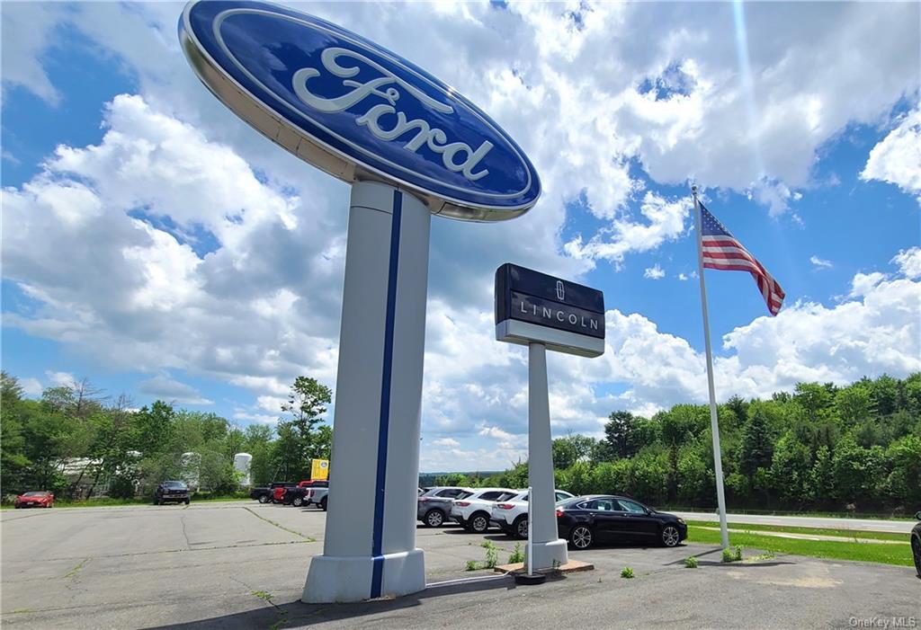
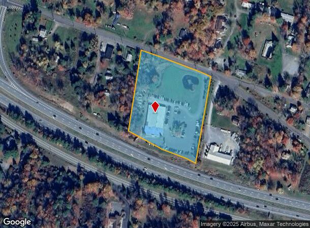
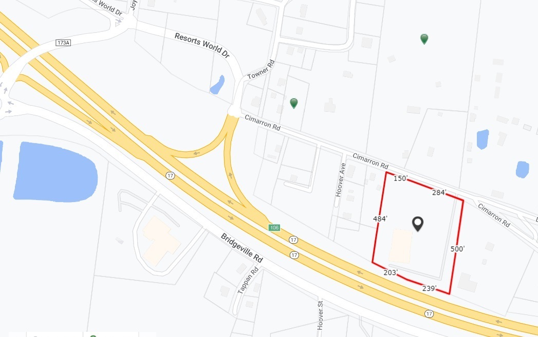
Property Record
102 Cimarron Rd, Monticello, NY 12701
NEARBY LISTINGS FOR SALE OR LEASE
Property Detail
102 Cimarron Rd
Vehiclerentalsvehiclesales
Sullivan
X
New York
36105C0469F
74.000
2024
4.72 AC
2023
Hudson Valley Area
951701
Other Market Areas
17,000 SF
4689-031-0-0001-074-000
DEMOGRAPHICS near 102 Cimarron Rd
1 Mile
3 Mile
5 Mile
2024 Total Population
442
8,096
18,579
2029 Population
467
8,557
19,466
Pop Growth 2024-2029
+ 5.66%
+ 5.69%
+ 4.77%
Average Age
47
41
40
2024 Total Households
193
3,204
7,414
HH Growth 2024-2029
+ 5.70%
+ 5.99%
+ 5.08%
Median Household Inc
$85,937
$54,140
$50,641
Avg Household Size
2.30
2.30
2.40
2024 Avg HH Vehicles
2.00
2.00
2.00
Median Home Value
$240,740
$186,147
$199,133
Median Year Built
1971
1969
1975
Nearby Places
- Restaurants
- Banks
- Shops
- Fitness
- Groceries
PUBLIC TRANSPORTATION
AIRPORT
New York Stewart International
DRIVE
WALK
Distance
New York Stewart International
51 min
36.4 mi
Freight Ports
Port Newark Container Terminal
DRIVE
WALK
Distance
Port Newark Container Terminal
119 min
93.4 mi
Nearby Properties
Address
Land Use
TOTAL SIZE
Lot Size
Zoning
Address
Land Use
TOTAL SIZE
Lot Size
Zoning
1,777,903 SF
117.40 AC
PRD
Address
Land Use
TOTAL SIZE
Lot Size
Zoning
423,920 SF
131.50 AC
PRD
Address
Land Use
TOTAL SIZE
Lot Size
Zoning
3,123 SF
48.30 AC
RR
Address
Land Use
TOTAL SIZE
Lot Size
Zoning
69,742 SF
21.63 AC
PRD
Address
Land Use
TOTAL SIZE
Lot Size
Zoning
209,366 SF
32.32 AC
HC1
Address
Land Use
TOTAL SIZE
Lot Size
Zoning
100,167 SF
9.60 AC
BLI
Address
Land Use
TOTAL SIZE
Lot Size
Zoning
17,812 SF
3.50 AC
RM
Address
Land Use
TOTAL SIZE
Lot Size
Zoning
3,699 SF
334.81 AC
PUD #6
Address
Land Use
TOTAL SIZE
Lot Size
Zoning
14,841 SF
17.19 AC
HC2
Address
Land Use
TOTAL SIZE
Lot Size
Zoning
104,739 SF
9.68 AC
HC2
Address
Land Use
TOTAL SIZE
Lot Size
Zoning
648 SF
74.20 AC
RR
Address
Land Use
TOTAL SIZE
Lot Size
Zoning
54,525 SF
6.33 AC
HC
Address
Land Use
TOTAL SIZE
Lot Size
Zoning
6,042 SF
12.38 AC
EBG
Address
Land Use
TOTAL SIZE
Lot Size
Zoning
82,342 SF
13.65 AC
HC2
Address
Land Use
TOTAL SIZE
Lot Size
Zoning
10,787 SF
13.80 AC
HC
Address
Land Use
TOTAL SIZE
Lot Size
Zoning
55,365 SF
11.85 AC
HC2
Address
Land Use
TOTAL SIZE
Lot Size
Zoning
52,290 SF
26.40 AC
RM
Address
Land Use
TOTAL SIZE
Lot Size
Zoning
28,392 SF
8.40 AC
RM
Address
Land Use
TOTAL SIZE
Lot Size
Zoning
5,627 SF
10.05 AC
SR
Address
Land Use
TOTAL SIZE
Lot Size
Zoning
29,320 SF
9.31 AC
HC2
Address
Land Use
TOTAL SIZE
Lot Size
Zoning
66,151 SF
2.80 AC
RM
Address
Land Use
TOTAL SIZE
Lot Size
Zoning
13,668 SF
3.05 AC
RM
Address
Land Use
TOTAL SIZE
Lot Size
Zoning
59,120 SF
7.30 AC
EBV
Address
Land Use
TOTAL SIZE
Lot Size
Zoning
2,400 SF
1,079.65 AC
E
Address
Land Use
TOTAL SIZE
Lot Size
Zoning
14,689 SF
7.71 AC
RM
Address
Land Use
TOTAL SIZE
Lot Size
Zoning
10,008 SF
1.32 AC
B2
Address
Land Use
TOTAL SIZE
Lot Size
Zoning
3,204 SF
1.39 AC
EBV
Address
Land Use
TOTAL SIZE
Lot Size
Zoning
19,152 SF
4.10 AC
BL1
Address
Land Use
TOTAL SIZE
Lot Size
Zoning
13,268 SF
4.58 AC
RM
Address
Land Use
TOTAL SIZE
Lot Size
Zoning
11,217 SF
1.03 AC
B2
The World's #1 Commercial Real Estate Marketplace
Connect with us
© 2025 CoStar Group
The information above has been obtained from sources believed reliable. While we do not doubt its accuracy we have not verified it and make no guarantee, warranty or representation about it. It is your responsibility to independently confirm its accuracy and completeness. Any projections, opinions, assumptions, or estimates used are for example only and do not represent the current or future performance of the property. The value of this transaction to you depends on tax and other factors which should be evaluated by your tax, financial, and legal advisors. You and your advisors should conduct a careful, independent investigation of the property to determine to your satisfaction the suitability of the property for your needs.