Property Record
1020 Space Center Dr, Colorado Springs, CO 80915

This Property Is For Sale
NEARBY LISTINGS FOR SALE OR LEASE
-
-
-
-
-
-
-
-
-
NWC of S Powers Blvd and Airport Rd
Colorado Springs, CO 80916
$193,404 - $15,938,906
0.55 - 38.79 AC Lot
Land
-
-
-
View all Colorado Springs listings for sale on LoopNet.com
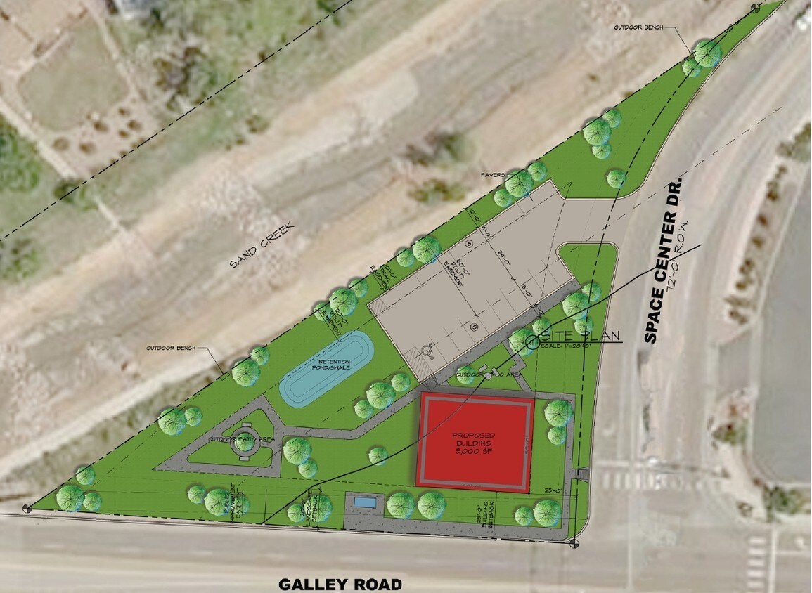
Property Detail
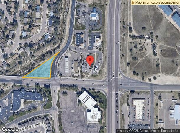
1020 Space Center Dr
Colorado Springs, CO
Creekside Center Fil No 1
64121-01-026
LOT 1 CREEKSIDE CENTER FIL NO 1
Commercialacreage
El Paso
X
Colorado
08041C0751G
1
2023
0.75 AC
2023
Southeast
005900
Colorado Springs
DEMOGRAPHICS near 1020 Space Center Dr
1 Mile
3 Mile
5 Mile
2024 Total Population
6,714
98,477
237,700
2029 Population
7,072
102,978
248,017
Pop Growth 2024-2029
+ 5.33%
+ 4.57%
+ 4.34%
Average Age
37
37
37
2024 Total Households
2,709
38,295
93,386
HH Growth 2024-2029
+ 5.72%
+ 4.90%
+ 4.62%
Median Household Inc
$59,752
$63,357
$65,054
Avg Household Size
2.40
2.50
2.40
2024 Avg HH Vehicles
2.00
2.00
2.00
Median Home Value
$303,612
$312,731
$329,137
Median Year Built
1979
1980
1981
Nearby Places
- Restaurants
- Banks
- Shops
- Fitness
- Groceries
PUBLIC TRANSPORTATION
AIRPORT
City of Colorado Springs Municipal
Drive
Walk
Distance
City of Colorado Springs Municipal
10 min
4.2 mi
Freight Ports
Tulsa Port Of Catoosa
Drive
Walk
Distance
Tulsa Port Of Catoosa
735 min
689.7 mi
Nearby Properties
Address
Land Use
TOTAL SIZE
Lot Size
Zoning
Address
Land Use
TOTAL SIZE
Lot Size
Zoning
3,486,127 SF
69.25 AC
APD AO APZ
Address
Land Use
TOTAL SIZE
Lot Size
Zoning
8,806 SF
124.24 AC
PF AO APZ2
Address
Land Use
TOTAL SIZE
Lot Size
Zoning
339,516 SF
1,090.76 AC
APD RPZ AO
Address
Land Use
TOTAL SIZE
Lot Size
Zoning
126,860 SF
23.92 AC
OC/CR AO
Address
Land Use
TOTAL SIZE
Lot Size
Zoning
9,421 SF
15.56 AC
Address
Land Use
TOTAL SIZE
Lot Size
Zoning
73,203 SF
3,971.89 AC
R1-6 APD A
Address
Land Use
TOTAL SIZE
Lot Size
Zoning
124,597 SF
10.89 AC
PIP2/CR AO
Address
Land Use
TOTAL SIZE
Lot Size
Zoning
210,964 SF
27.40 AC
PIP2 AO AP
Address
Land Use
TOTAL SIZE
Lot Size
Zoning
327,692 SF
16.30 AC
OC SS APZ2
Address
Land Use
TOTAL SIZE
Lot Size
Zoning
138,474 SF
12.44 AC
PBC AO APZ
Address
Land Use
TOTAL SIZE
Lot Size
Zoning
276,497 SF
9.32 AC
PBC CU AO
Address
Land Use
TOTAL SIZE
Lot Size
Zoning
167,120 SF
10.59 AC
C6/CR CU
Address
Land Use
TOTAL SIZE
Lot Size
Zoning
93,955 SF
5.73 AC
PUD AO
Address
Land Use
TOTAL SIZE
Lot Size
Zoning
569,412 SF
24.75 AC
PBC AO
Address
Land Use
TOTAL SIZE
Lot Size
Zoning
135,296 SF
11.67 AC
PIP2/CR UV
Address
Land Use
TOTAL SIZE
Lot Size
Zoning
264,579 SF
8.81 AC
PUD AO
Address
Land Use
TOTAL SIZE
Lot Size
Zoning
131,545 SF
12.46 AC
R5/CR CU
Address
Land Use
TOTAL SIZE
Lot Size
Zoning
109,200 SF
6.13 AC
PIP2/CR AO
Address
Land Use
TOTAL SIZE
Lot Size
Zoning
119,962 SF
14.06 AC
CR CAD-O
Address
Land Use
TOTAL SIZE
Lot Size
Zoning
232,918 SF
11.31 AC
R5 AO
Address
Land Use
TOTAL SIZE
Lot Size
Zoning
234,628 SF
9.41 AC
R5 AO
Address
Land Use
TOTAL SIZE
Lot Size
Zoning
87,577 SF
14.24 AC
CS CAD-O
Address
Land Use
TOTAL SIZE
Lot Size
Zoning
210,753 SF
20.68 AC
PBC CU AO
Address
Land Use
TOTAL SIZE
Lot Size
Zoning
117,631 SF
4.64 AC
PBC HR AO
Address
Land Use
TOTAL SIZE
Lot Size
Zoning
97,258 SF
5 AC
PUD APZ1 A
Address
Land Use
TOTAL SIZE
Lot Size
Zoning
70,466 SF
4.26 AC
OC AO
Address
Land Use
TOTAL SIZE
Lot Size
Zoning
93,955 SF
5.72 AC
PUD AO
Address
Land Use
TOTAL SIZE
Lot Size
Zoning
98,638 SF
7.22 AC
PBC AO
Address
Land Use
TOTAL SIZE
Lot Size
Zoning
217,418 SF
13.05 AC
SU AO
Address
Land Use
TOTAL SIZE
Lot Size
Zoning
173,951 SF
18.20 AC
PBC AO
Start a new search to find other properties for sale or lease
Connect with us
© 2024 CoStar Group
The information above has been obtained from sources believed reliable. While we do not doubt its accuracy we have not verified it and make no guarantee, warranty or representation about it. It is your responsibility to independently confirm its accuracy and completeness. Any projections, opinions, assumptions, or estimates used are for example only and do not represent the current or future performance of the property. The value of this transaction to you depends on tax and other factors which should be evaluated by your tax, financial, and legal advisors. You and your advisors should conduct a careful, independent investigation of the property to determine to your satisfaction the suitability of the property for your needs.