Property Record
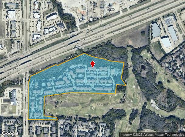
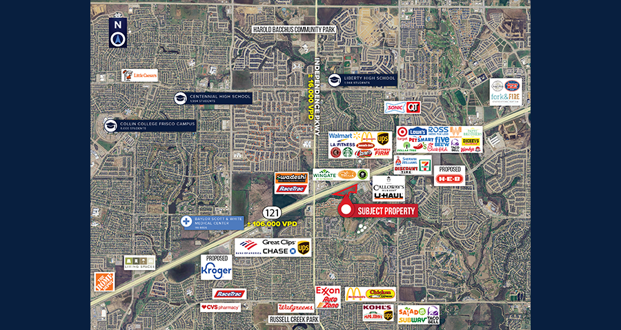
10200 Independence Pky, Plano, TX 75025

This Property Is For Sale
NEARBY LISTINGS FOR SALE OR LEASE
Property Detail
10200 Independence Pky
Dallas-Fort Worth-Arlington, TX
Estancia At Ridgeview Ranch (Cpl)
R-9479-00A-001R-1
ESTANCIA AT RIDGEVIEW RANCH (CPL), BLK A, LOT 1R; REPLAT
Multifamilydwelling
Collin
AE
Texas
48085C0380K
1r
2023
36.28 AC
2023
Plano
031665
Dallas/Ft Worth
537,872 SF
DEMOGRAPHICS near 10200 Independence Pky
1 Mile
3 Mile
5 Mile
2024 Total Population
13,189
138,072
372,958
2029 Population
16,090
168,777
455,906
Pop Growth 2024-2029
+ 22.00%
+ 22.24%
+ 22.24%
Average Age
36
37
37
2024 Total Households
4,548
46,533
135,126
HH Growth 2024-2029
+ 22.12%
+ 22.45%
+ 22.55%
Median Household Inc
$120,783
$140,983
$116,845
Avg Household Size
2.90
2.90
2.70
2024 Avg HH Vehicles
2.00
2.00
2.00
Median Home Value
$446,390
$457,085
$439,538
Median Year Built
2002
2002
2003
Nearby Places
- Restaurants
- Banks
- Shops
- Fitness
- Groceries
PUBLIC TRANSPORTATION
AIRPORT
Dallas Love Field
DRIVE
WALK
Distance
Dallas Love Field
35 min
25.7 mi
Dallas-Fort Worth International
DRIVE
WALK
Distance
Dallas-Fort Worth International
32 min
26.6 mi
Freight Ports
Port of Shreveport
DRIVE
WALK
Distance
Port of Shreveport
239 min
219.1 mi
Nearby Properties
Address
Land Use
TOTAL SIZE
Lot Size
Zoning
Address
Land Use
TOTAL SIZE
Lot Size
Zoning
741,280 SF
90.87 AC
Address
Land Use
TOTAL SIZE
Lot Size
Zoning
766,124 SF
62.04 AC
Address
Land Use
TOTAL SIZE
Lot Size
Zoning
535,339 SF
54.76 AC
Address
Land Use
TOTAL SIZE
Lot Size
Zoning
256,445 SF
10.42 AC
Address
Land Use
TOTAL SIZE
Lot Size
Zoning
557,288 SF
9.18 AC
Address
Land Use
TOTAL SIZE
Lot Size
Zoning
511,762 SF
28.81 AC
Address
Land Use
TOTAL SIZE
Lot Size
Zoning
649,703 SF
31.92 AC
MF
Address
Land Use
TOTAL SIZE
Lot Size
Zoning
419,994 SF
19.83 AC
MF-M
Address
Land Use
TOTAL SIZE
Lot Size
Zoning
584,548 SF
33.76 AC
MF
Address
Land Use
TOTAL SIZE
Lot Size
Zoning
435,382 SF
6.95 AC
MF-E
Address
Land Use
TOTAL SIZE
Lot Size
Zoning
556,741 SF
8.70 AC
MF-R
Address
Land Use
TOTAL SIZE
Lot Size
Zoning
443,704 SF
18.87 AC
MFM
Address
Land Use
TOTAL SIZE
Lot Size
Zoning
508,028 SF
14.61 AC
Address
Land Use
TOTAL SIZE
Lot Size
Zoning
294,229 SF
32.11 AC
Address
Land Use
TOTAL SIZE
Lot Size
Zoning
471,114 SF
26.05 AC
MF-M
Address
Land Use
TOTAL SIZE
Lot Size
Zoning
408,042 SF
18.47 AC
MF-M
Address
Land Use
TOTAL SIZE
Lot Size
Zoning
397,395 SF
12.25 AC
Address
Land Use
TOTAL SIZE
Lot Size
Zoning
393,074 SF
24.02 AC
MFM
Address
Land Use
TOTAL SIZE
Lot Size
Zoning
390,948 SF
21.95 AC
MF-M
Address
Land Use
TOTAL SIZE
Lot Size
Zoning
493,621 SF
17 AC
APTS
Address
Land Use
TOTAL SIZE
Lot Size
Zoning
357,097 SF
19.68 AC
MF-M
Address
Land Use
TOTAL SIZE
Lot Size
Zoning
483,386 SF
4.62 AC
MF-R
Address
Land Use
TOTAL SIZE
Lot Size
Zoning
255,051 SF
4.71 AC
Address
Land Use
TOTAL SIZE
Lot Size
Zoning
359,701 SF
4.62 AC
MF-E
Address
Land Use
TOTAL SIZE
Lot Size
Zoning
337,425 SF
7.44 AC
MF-E
Address
Land Use
TOTAL SIZE
Lot Size
Zoning
345,481 SF
5.01 AC
Address
Land Use
TOTAL SIZE
Lot Size
Zoning
135,083 SF
85.17 AC
Address
Land Use
TOTAL SIZE
Lot Size
Zoning
334,313 SF
22.10 AC
Address
Land Use
TOTAL SIZE
Lot Size
Zoning
357,411 SF
13.58 AC
MF-M
The World's #1 Commercial Real Estate Marketplace
Connect with us
© 2025 CoStar Group
The information above has been obtained from sources believed reliable. While we do not doubt its accuracy we have not verified it and make no guarantee, warranty or representation about it. It is your responsibility to independently confirm its accuracy and completeness. Any projections, opinions, assumptions, or estimates used are for example only and do not represent the current or future performance of the property. The value of this transaction to you depends on tax and other factors which should be evaluated by your tax, financial, and legal advisors. You and your advisors should conduct a careful, independent investigation of the property to determine to your satisfaction the suitability of the property for your needs.