Property Record
10209 N 35Th Ave, Phoenix, AZ 85051

NEARBY LISTINGS FOR SALE OR LEASE
Property Detail
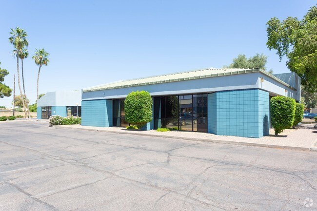
10209 N 35Th Ave
Phoenix-Mesa-Scottsdale, AZ
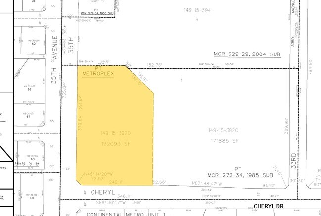
Metroplex
149-15-392D
METROPLEX MCR 272-34
Storebuilding
Maricopa
X
Arizona
04013C1710L
1
2025
2.80 AC
2025
N Phoenix/I-17 Corr
104205
Phoenix
24,568 SF
DEMOGRAPHICS near 10209 N 35Th Ave
1 Mile
3 Mile
5 Mile
2024 Total Population
19,915
184,425
455,177
2029 Population
21,503
198,956
490,453
Pop Growth 2024-2029
+ 7.97%
+ 7.88%
+ 7.75%
Average Age
37
37
37
2024 Total Households
7,254
66,931
163,833
HH Growth 2024-2029
+ 8.16%
+ 8.14%
+ 8.04%
Median Household Inc
$55,421
$54,134
$57,354
Avg Household Size
2.60
2.60
2.60
2024 Avg HH Vehicles
2.00
2.00
2.00
Median Home Value
$272,916
$274,868
$296,674
Median Year Built
1975
1976
1976
Nearby Places
Map Layers
Map Styles
 Street
 Aerial
- Restaurants
- Banks
- Shops
- Fitness
- Groceries
PUBLIC TRANSPORTATION
AIRPORT
Phoenix Sky Harbor International
DRIVE
WALK
Distance
Phoenix Sky Harbor International
25 min
17.7 mi
Phoenix-Mesa Gateway
DRIVE
WALK
Distance
Phoenix-Mesa Gateway
59 min
44.8 mi
Nearby Properties
Address
Land Use
TOTAL SIZE
Lot Size
Zoning
Address
Land Use
TOTAL SIZE
Lot Size
Zoning
249,119 SF
15.40 AC
PUD
Address
Land Use
TOTAL SIZE
Lot Size
Zoning
10.70 AC
I-P
Address
Land Use
TOTAL SIZE
Lot Size
Zoning
98,760 SF
6.76 AC
A-1
Address
Land Use
TOTAL SIZE
Lot Size
Zoning
742,601 SF
295.89 AC
R-8
Address
Land Use
TOTAL SIZE
Lot Size
Zoning
3.58 AC
Address
Land Use
TOTAL SIZE
Lot Size
Zoning
19,474 SF
8.43 AC
C-3
Address
Land Use
TOTAL SIZE
Lot Size
Zoning
1.93 AC
C-C
Address
Land Use
TOTAL SIZE
Lot Size
Zoning
3,241 SF
2.13 AC
C-N
Address
Land Use
TOTAL SIZE
Lot Size
Zoning
74,376 SF
2.12 AC
C-N
Address
Land Use
TOTAL SIZE
Lot Size
Zoning
2.62 AC
IND.PK.
Address
Land Use
TOTAL SIZE
Lot Size
Zoning
215,150 SF
13.24 AC
R-3
Address
Land Use
TOTAL SIZE
Lot Size
Zoning
16,284 SF
3.77 AC
M-H
Address
Land Use
TOTAL SIZE
Lot Size
Zoning
276,102 SF
39.72 AC
AG
Address
Land Use
TOTAL SIZE
Lot Size
Zoning
4.43 AC
Address
Land Use
TOTAL SIZE
Lot Size
Zoning
146,867 SF
12.95 AC
CPGCP
Address
Land Use
TOTAL SIZE
Lot Size
Zoning
268,958 SF
38.42 AC
R-6
Address
Land Use
TOTAL SIZE
Lot Size
Zoning
469,322 SF
22.40 AC
M-H
Address
Land Use
TOTAL SIZE
Lot Size
Zoning
212,227 SF
27.71 AC
R-6
Address
Land Use
TOTAL SIZE
Lot Size
Zoning
584,674 SF
27.83 AC
R-3A
Address
Land Use
TOTAL SIZE
Lot Size
Zoning
362,729 SF
21.85 AC
Address
Land Use
TOTAL SIZE
Lot Size
Zoning
196,254 SF
17.36 AC
R2
Address
Land Use
TOTAL SIZE
Lot Size
Zoning
154,128 SF
9.32 AC
I-1
Address
Land Use
TOTAL SIZE
Lot Size
Zoning
2.99 AC
C-R
Address
Land Use
TOTAL SIZE
Lot Size
Zoning
228,072 SF
14.72 AC
C-C
Address
Land Use
TOTAL SIZE
Lot Size
Zoning
153,980 SF
20.11 AC
R-8
Address
Land Use
TOTAL SIZE
Lot Size
Zoning
122,646 SF
14.69 AC
I-P
Address
Land Use
TOTAL SIZE
Lot Size
Zoning
387,832 SF
20.25 AC
M-H
Address
Land Use
TOTAL SIZE
Lot Size
Zoning
144,000 SF
12.50 AC
C-C
Address
Land Use
TOTAL SIZE
Lot Size
Zoning
99,877 SF
13.52 AC
R-8
Address
Land Use
TOTAL SIZE
Lot Size
Zoning
96,328 SF
15.58 AC
M-H
The World's #1 Commercial Real Estate Marketplace
Connect with us
© 2025 CoStar Group
The information above has been obtained from sources believed reliable. While we do not doubt its accuracy we have not verified it and make no guarantee, warranty or representation about it. It is your responsibility to independently confirm its accuracy and completeness. Any projections, opinions, assumptions, or estimates used are for example only and do not represent the current or future performance of the property. The value of this transaction to you depends on tax and other factors which should be evaluated by your tax, financial, and legal advisors. You and your advisors should conduct a careful, independent investigation of the property to determine to your satisfaction the suitability of the property for your needs.