Property Record
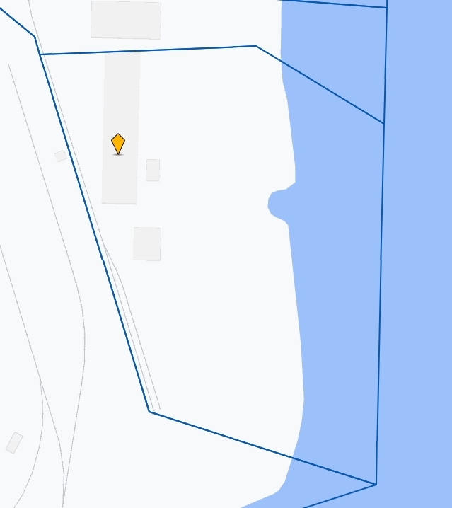
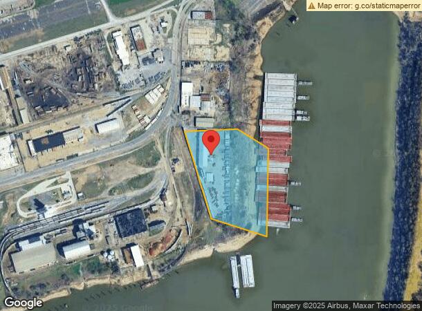
1029 Channel Ave, Memphis, TN 38106
NEARBY LISTINGS FOR SALE OR LEASE
Property Detail
1029 Channel Ave
Memphis, TN-MS-AR
Mckellar Lake
05-0107-0-0010
SS CHANNEL PLACE TO MCKELLAR LAKE
Autorepair
Shelby
AE
Tennessee
05035C0475E
2
2023
14.10 AC
2024
South
005700
Memphis
32,320 SF
DEMOGRAPHICS near 1029 Channel Ave
1 Mile
3 Mile
5 Mile
2024 Total Population
1,323
26,462
94,757
2029 Population
1,364
27,115
95,525
Pop Growth 2024-2029
+ 3.10%
+ 2.47%
+ 0.81%
Average Age
43
40
40
2024 Total Households
572
12,076
42,766
HH Growth 2024-2029
+ 2.97%
+ 2.05%
+ 0.67%
Median Household Inc
$20,710
$32,650
$35,617
Avg Household Size
2.30
2.10
2.10
2024 Avg HH Vehicles
1.00
1.00
1.00
Median Home Value
$77,034
$85,424
$83,576
Median Year Built
1957
1962
1963
Nearby Places
- Restaurants
- Banks
- Shops
- Fitness
- Groceries
PUBLIC TRANSPORTATION
COMMUTER RAIL
Central Station (Riverfront Loop - Memphis Area Transit Authority Trolley (MataTrolley))
DRIVE
WALK
Distance
Central Station (Riverfront Loop - Memphis Area Transit Authority Trolley (MataTrolley))
8 min
3.4 mi
AIRPORT
Memphis International
DRIVE
WALK
Distance
Memphis International
19 min
10.7 mi
Freight Ports
Port of Shreveport
DRIVE
WALK
Distance
Port of Shreveport
402 min
370.0 mi
Nearby Properties
Address
Land Use
TOTAL SIZE
Lot Size
Zoning
Address
Land Use
TOTAL SIZE
Lot Size
Zoning
438,763 SF
64.67 AC
IH
Address
Land Use
TOTAL SIZE
Lot Size
Zoning
233,547 SF
16.70 AC
SM
Address
Land Use
TOTAL SIZE
Lot Size
Zoning
71,987 SF
2.26 AC
SM
Address
Land Use
TOTAL SIZE
Lot Size
Zoning
60,363 SF
1.33 AC
SM
Address
Land Use
TOTAL SIZE
Lot Size
Zoning
74,369 SF
0.78 AC
SM
Address
Land Use
TOTAL SIZE
Lot Size
Zoning
113,416 SF
3.35 AC
SDR
Address
Land Use
TOTAL SIZE
Lot Size
Zoning
48,729 SF
3.66 AC
BR
Address
Land Use
TOTAL SIZE
Lot Size
Zoning
57,424 SF
0.83 AC
SM
Address
Land Use
TOTAL SIZE
Lot Size
Zoning
42,351 SF
0.95 AC
SE
Address
Land Use
TOTAL SIZE
Lot Size
Zoning
32,413 SF
0.44 AC
SM
Address
Land Use
TOTAL SIZE
Lot Size
Zoning
70,634 SF
0.54 AC
SM
Address
Land Use
TOTAL SIZE
Lot Size
Zoning
26,824 SF
0.39 AC
SM
Address
Land Use
TOTAL SIZE
Lot Size
Zoning
109,602 SF
1.24 AC
SM
Address
Land Use
TOTAL SIZE
Lot Size
Zoning
62,470 SF
3.68 AC
BR
Address
Land Use
TOTAL SIZE
Lot Size
Zoning
253,883 SF
37.28 AC
IH
Address
Land Use
TOTAL SIZE
Lot Size
Zoning
61,469 SF
0.95 AC
SM
Address
Land Use
TOTAL SIZE
Lot Size
Zoning
26,952 SF
2.79 AC
BR
Address
Land Use
TOTAL SIZE
Lot Size
Zoning
56,050 SF
0.20 AC
SM
Address
Land Use
TOTAL SIZE
Lot Size
Zoning
73,409 SF
0.82 AC
SM
Address
Land Use
TOTAL SIZE
Lot Size
Zoning
55,125 SF
0.94 AC
SM
Address
Land Use
TOTAL SIZE
Lot Size
Zoning
342,931 SF
20.87 AC
IH
Address
Land Use
TOTAL SIZE
Lot Size
Zoning
451,501 SF
21.78 AC
IH
Address
Land Use
TOTAL SIZE
Lot Size
Zoning
195,232 SF
1.59 AC
SE
Address
Land Use
TOTAL SIZE
Lot Size
Zoning
43,994 SF
1.36 AC
SM
Address
Land Use
TOTAL SIZE
Lot Size
Zoning
222,777 SF
119.84 AC
IH
Address
Land Use
TOTAL SIZE
Lot Size
Zoning
39,812 SF
1.90 AC
BR
Address
Land Use
TOTAL SIZE
Lot Size
Zoning
23,094 SF
2.92 AC
BR
Address
Land Use
TOTAL SIZE
Lot Size
Zoning
29,840 SF
1.12 AC
R-R
Address
Land Use
TOTAL SIZE
Lot Size
Zoning
381.30 AC
R-15
Address
Land Use
TOTAL SIZE
Lot Size
Zoning
26,068 SF
0.40 AC
SM
The World's #1 Commercial Real Estate Marketplace
Connect with us
© 2025 CoStar Group
The information above has been obtained from sources believed reliable. While we do not doubt its accuracy we have not verified it and make no guarantee, warranty or representation about it. It is your responsibility to independently confirm its accuracy and completeness. Any projections, opinions, assumptions, or estimates used are for example only and do not represent the current or future performance of the property. The value of this transaction to you depends on tax and other factors which should be evaluated by your tax, financial, and legal advisors. You and your advisors should conduct a careful, independent investigation of the property to determine to your satisfaction the suitability of the property for your needs.