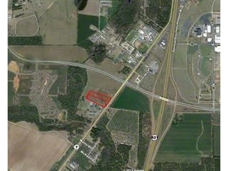
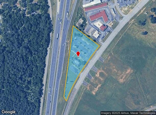
Property Record
103 General Courtney Hodges Blvd, Perry, GA 31069
NEARBY LISTINGS FOR SALE OR LEASE
Property Detail
103 General Courtney Hodges Blvd
Warner Robins, GA
Fairview Dr P-34
0P0340003000
3.44 ACRES LL 314 13TH LD
Governmentalpublicusegeneral
Houston
X
Georgia
13193C0250E
139
0
3.44 AC
2024
Perry/Warner Robins
021300
Other Market Areas
5,723 SF
DEMOGRAPHICS near 103 General Courtney Hodges Blvd
1 Mile
3 Mile
5 Mile
2024 Total Population
658
5,481
17,353
2029 Population
726
6,039
19,154
Pop Growth 2024-2029
+ 10.33%
+ 10.18%
+ 10.38%
Average Age
41
41
40
2024 Total Households
277
2,186
6,842
HH Growth 2024-2029
+ 10.11%
+ 10.06%
+ 10.22%
Median Household Inc
$87,628
$54,129
$63,920
Avg Household Size
2.40
2.40
2.40
2024 Avg HH Vehicles
2.00
2.00
2.00
Median Home Value
$158,646
$142,142
$168,948
Median Year Built
1982
1979
1987
Nearby Places
- Restaurants
- Banks
- Shops
- Fitness
- Groceries
SALE & LEASE HISTORY
LISTING DATE
SALE/LEASE

Sep 24, 2016
For Sale
Nov 23, 2016
For Sale
Mar 06, 2017
For Sale
Nearby Properties
Address
Land Use
TOTAL SIZE
Lot Size
Zoning
Address
Land Use
TOTAL SIZE
Lot Size
Zoning
68,186 SF
562.30 AC
GU
Address
Land Use
TOTAL SIZE
Lot Size
Zoning
262,500 SF
20 AC
GU
Address
Land Use
TOTAL SIZE
Lot Size
Zoning
528,578 SF
32.75 AC
M2
Address
Land Use
TOTAL SIZE
Lot Size
Zoning
49,947 SF
4.03 AC
C2
Address
Land Use
TOTAL SIZE
Lot Size
Zoning
78,010 SF
20 AC
C2
Address
Land Use
TOTAL SIZE
Lot Size
Zoning
304,196 SF
177.46 AC
M1
Address
Land Use
TOTAL SIZE
Lot Size
Zoning
25,002 SF
15.17 AC
RM-2
Address
Land Use
TOTAL SIZE
Lot Size
Zoning
442.42 AC
M2
Address
Land Use
TOTAL SIZE
Lot Size
Zoning
151,525 SF
17.55 AC
C2
Address
Land Use
TOTAL SIZE
Lot Size
Zoning
19,125 SF
27.94 AC
R1
Address
Land Use
TOTAL SIZE
Lot Size
Zoning
31,248 SF
10.30 AC
RM-2
Address
Land Use
TOTAL SIZE
Lot Size
Zoning
255.39 AC
GU/M1
Address
Land Use
TOTAL SIZE
Lot Size
Zoning
4,820 SF
14.59 AC
RM-2
Address
Land Use
TOTAL SIZE
Lot Size
Zoning
12,000 SF
7.27 AC
RM-2
Address
Land Use
TOTAL SIZE
Lot Size
Zoning
226.03 AC
GU
Address
Land Use
TOTAL SIZE
Lot Size
Zoning
134,145 SF
3.08 AC
M2
Address
Land Use
TOTAL SIZE
Lot Size
Zoning
43,486 SF
9.70 AC
FBR
Address
Land Use
TOTAL SIZE
Lot Size
Zoning
134,145 SF
3.08 AC
M2
Address
Land Use
TOTAL SIZE
Lot Size
Zoning
38,066 SF
11.73 AC
GU
Address
Land Use
TOTAL SIZE
Lot Size
Zoning
44,832 SF
11.95 AC
GU
Address
Land Use
TOTAL SIZE
Lot Size
Zoning
42,908 SF
7.93 AC
C2
Address
Land Use
TOTAL SIZE
Lot Size
Zoning
4,820 SF
14.95 AC
RM-2
Address
Land Use
TOTAL SIZE
Lot Size
Zoning
6,948 SF
10 AC
C2
Address
Land Use
TOTAL SIZE
Lot Size
Zoning
33,970 SF
2.46 AC
C2
Address
Land Use
TOTAL SIZE
Lot Size
Zoning
253.52 AC
M1 RAG
Address
Land Use
TOTAL SIZE
Lot Size
Zoning
13,888 SF
2.90 AC
C1
Address
Land Use
TOTAL SIZE
Lot Size
Zoning
35.91 AC
M2
Address
Land Use
TOTAL SIZE
Lot Size
Zoning
30,451 SF
10.19 AC
C2
Address
Land Use
TOTAL SIZE
Lot Size
Zoning
13,792 SF
10 AC
C1
Address
Land Use
TOTAL SIZE
Lot Size
Zoning
14,161 SF
3.78 AC
C1
The World's #1 Commercial Real Estate Marketplace
Connect with us
© 2025 CoStar Group
The information above has been obtained from sources believed reliable. While we do not doubt its accuracy we have not verified it and make no guarantee, warranty or representation about it. It is your responsibility to independently confirm its accuracy and completeness. Any projections, opinions, assumptions, or estimates used are for example only and do not represent the current or future performance of the property. The value of this transaction to you depends on tax and other factors which should be evaluated by your tax, financial, and legal advisors. You and your advisors should conduct a careful, independent investigation of the property to determine to your satisfaction the suitability of the property for your needs.