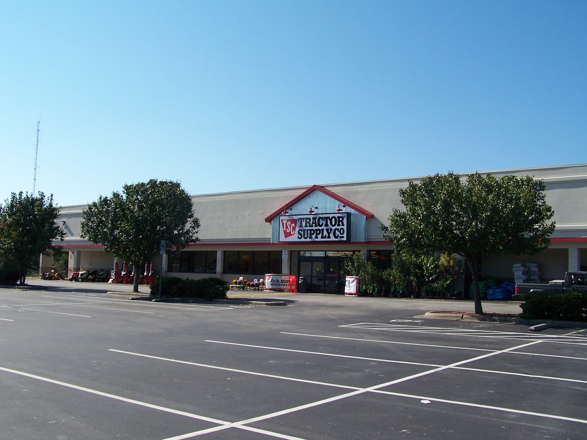
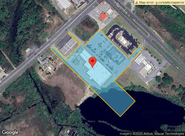
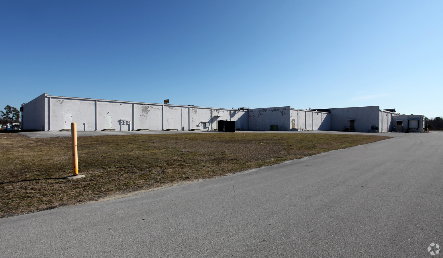
Property Record
1030 W New Bern Rd, Kinston, NC 28504
NEARBY LISTINGS FOR SALE OR LEASE
Property Detail
1030 W New Bern Rd
Kinston, NC
Kinston Marketplace
451402793770
HWY 70 WEST LOT 1 FLOODED 12/16
Wholesaleoutletdiscountstore
Lenoir
AE
North Carolina
3720450400K
1
2024
7.92 AC
2024
North Carolina Southeast Area
011301
Other Market Areas
54,758 SF
DEMOGRAPHICS near 1030 W New Bern Rd
1 Mile
3 Mile
5 Mile
2024 Total Population
95
18,675
28,599
2029 Population
93
18,747
28,461
Pop Growth 2024-2029
(2.11%)
+ 0.39%
(0.48%)
Average Age
41
42
43
2024 Total Households
38
8,132
12,272
HH Growth 2024-2029
0.00%
+ 0.43%
(0.46%)
Median Household Inc
$41,562
$31,665
$36,398
Avg Household Size
2.40
2.20
2.20
2024 Avg HH Vehicles
2.00
1.00
2.00
Median Home Value
$69,444
$95,047
$104,165
Median Year Built
1986
1966
1972
Nearby Places
- Restaurants
- Banks
- Shops
- Fitness
- Groceries
PUBLIC TRANSPORTATION
AIRPORT
Albert J Ellis
DRIVE
WALK
Distance
Albert J Ellis
60 min
34.0 mi
Pitt-Greenville
DRIVE
WALK
Distance
Pitt-Greenville
47 min
36.3 mi
Freight Ports
Port of Morehead City
DRIVE
WALK
Distance
Port of Morehead City
109 min
76.4 mi
SALE & LEASE HISTORY
LISTING DATE
SALE/LEASE

Sep 25, 2016
For Lease
Nearby Properties
Address
Land Use
TOTAL SIZE
Lot Size
Zoning
Address
Land Use
TOTAL SIZE
Lot Size
Zoning
598,078 SF
278.06 AC
RA20
Address
Land Use
TOTAL SIZE
Lot Size
Zoning
357,454 SF
54.92 AC
OI
Address
Land Use
TOTAL SIZE
Lot Size
Zoning
217,381 SF
77.79 AC
O&I
Address
Land Use
TOTAL SIZE
Lot Size
Zoning
185,613 SF
12.24 AC
SC
Address
Land Use
TOTAL SIZE
Lot Size
Zoning
5.78 AC
RA6
Address
Land Use
TOTAL SIZE
Lot Size
Zoning
166,712 SF
23.48 AC
RA8
Address
Land Use
TOTAL SIZE
Lot Size
Zoning
65,151 SF
24 AC
I1
Address
Land Use
TOTAL SIZE
Lot Size
Zoning
750.08 AC
RA6
Address
Land Use
TOTAL SIZE
Lot Size
Zoning
118,696 SF
15.62 AC
IB
Address
Land Use
TOTAL SIZE
Lot Size
Zoning
525,504 SF
228 AC
I1
Address
Land Use
TOTAL SIZE
Lot Size
Zoning
139,392 SF
2.19 AC
RA6
Address
Land Use
TOTAL SIZE
Lot Size
Zoning
43,452 SF
2.89 AC
IB
Address
Land Use
TOTAL SIZE
Lot Size
Zoning
61,370 SF
20.71 AC
SC
Address
Land Use
TOTAL SIZE
Lot Size
Zoning
122,274 SF
1.86 AC
B2
Address
Land Use
TOTAL SIZE
Lot Size
Zoning
65,100 SF
1.91 AC
B2
Address
Land Use
TOTAL SIZE
Lot Size
Zoning
69,696 SF
0.32 AC
B2
Address
Land Use
TOTAL SIZE
Lot Size
Zoning
73,536 SF
5.38 AC
B1
Address
Land Use
TOTAL SIZE
Lot Size
Zoning
39,537 SF
1.58 AC
SC
Address
Land Use
TOTAL SIZE
Lot Size
Zoning
25,163 SF
159.12 AC
OI
Address
Land Use
TOTAL SIZE
Lot Size
Zoning
106,276 SF
8.84 AC
RA5
Address
Land Use
TOTAL SIZE
Lot Size
Zoning
77,500 SF
1.30 AC
B2
Address
Land Use
TOTAL SIZE
Lot Size
Zoning
115.74 AC
RA12
Address
Land Use
TOTAL SIZE
Lot Size
Zoning
83,088 SF
1.19 AC
B2
Address
Land Use
TOTAL SIZE
Lot Size
Zoning
35,906 SF
4.09 AC
Address
Land Use
TOTAL SIZE
Lot Size
Zoning
29,996 SF
7.34 AC
RA6
Address
Land Use
TOTAL SIZE
Lot Size
Zoning
43,295 SF
5.69 AC
SC
Address
Land Use
TOTAL SIZE
Lot Size
Zoning
11,270 SF
112 AC
RA6
Address
Land Use
TOTAL SIZE
Lot Size
Zoning
25,885 SF
88.62 AC
RA6
Address
Land Use
TOTAL SIZE
Lot Size
Zoning
14,706 SF
2.62 AC
B1
Address
Land Use
TOTAL SIZE
Lot Size
Zoning
39,450 SF
1.02 AC
B2
The World's #1 Commercial Real Estate Marketplace
Connect with us
© 2025 CoStar Group
The information above has been obtained from sources believed reliable. While we do not doubt its accuracy we have not verified it and make no guarantee, warranty or representation about it. It is your responsibility to independently confirm its accuracy and completeness. Any projections, opinions, assumptions, or estimates used are for example only and do not represent the current or future performance of the property. The value of this transaction to you depends on tax and other factors which should be evaluated by your tax, financial, and legal advisors. You and your advisors should conduct a careful, independent investigation of the property to determine to your satisfaction the suitability of the property for your needs.