Property Record
10305 W York St, Wichita, KS 67215
NEARBY LISTINGS FOR SALE OR LEASE
-
-
View all Wichita listings for sale on LoopNet.com
Property Detail
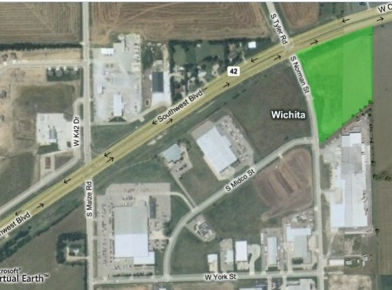
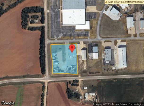
10305 W York St
Wichita, KS
Subd No.: T11
203-08-0-33-01-006.00
LOT 6 BLOCK A MID-CONTINENT INDUSTRIAL PARK I
Warehouse
Sedgwick
X
Kansas
20173C0477G
6
2023
3.01 AC
2023
Airport
009605
Wichita
8,000 SF
DEMOGRAPHICS near 10305 W York St
1 Mile
3 Mile
5 Mile
2024 Total Population
550
12,259
43,128
2029 Population
549
12,282
43,419
Pop Growth 2024-2029
(0.18%)
+ 0.19%
+ 0.67%
Average Age
35
37
40
2024 Total Households
182
4,174
15,938
HH Growth 2024-2029
0.00%
+ 0.14%
+ 0.61%
Median Household Inc
$109,500
$94,151
$80,444
Avg Household Size
3.00
2.90
2.60
2024 Avg HH Vehicles
2.00
2.00
2.00
Median Home Value
$194,117
$170,903
$187,493
Median Year Built
1997
1994
1989
Nearby Places
- Restaurants
- Banks
- Shops
- Fitness
- Groceries
PUBLIC TRANSPORTATION
AIRPORT
Wichita Dwight D Eisenhower Ntl
DRIVE
WALK
Distance
Wichita Dwight D Eisenhower Ntl
14 min
6.3 mi
Freight Ports
Tulsa Port Of Catoosa
DRIVE
WALK
Distance
Tulsa Port Of Catoosa
211 min
195.9 mi
Nearby Properties
Address
Land Use
TOTAL SIZE
Lot Size
Zoning
Address
Land Use
TOTAL SIZE
Lot Size
Zoning
393,823 SF
3.58 AC
LI
Address
Land Use
TOTAL SIZE
Lot Size
Zoning
84,959 SF
2 AC
LI
Address
Land Use
TOTAL SIZE
Lot Size
Zoning
1,669,552 SF
49.80 AC
LI,SF-20
Address
Land Use
TOTAL SIZE
Lot Size
Zoning
60,900 SF
281.77 AC
SF-5
Address
Land Use
TOTAL SIZE
Lot Size
Zoning
58,588 SF
11.08 AC
SF-5
Address
Land Use
TOTAL SIZE
Lot Size
Zoning
86,606 SF
7.51 AC
SF-20
Address
Land Use
TOTAL SIZE
Lot Size
Zoning
53,402 SF
26.35 AC
SF-5
Address
Land Use
TOTAL SIZE
Lot Size
Zoning
24,767 SF
8.96 AC
SF-5
Address
Land Use
TOTAL SIZE
Lot Size
Zoning
419,955 SF
52.54 AC
LI
Address
Land Use
TOTAL SIZE
Lot Size
Zoning
25,144 SF
3.90 AC
LI
Address
Land Use
TOTAL SIZE
Lot Size
Zoning
18,000 SF
8.24 AC
SF-5
Address
Land Use
TOTAL SIZE
Lot Size
Zoning
492,951 SF
72.04 AC
LI
Address
Land Use
TOTAL SIZE
Lot Size
Zoning
5,396 SF
138.07 AC
SF-5
Address
Land Use
TOTAL SIZE
Lot Size
Zoning
78,920 SF
22.15 AC
LI
Address
Land Use
TOTAL SIZE
Lot Size
Zoning
88,397 SF
28.37 AC
LI
Address
Land Use
TOTAL SIZE
Lot Size
Zoning
79,902 SF
19.98 AC
IP
Address
Land Use
TOTAL SIZE
Lot Size
Zoning
116,415 SF
11.14 AC
LI
Address
Land Use
TOTAL SIZE
Lot Size
Zoning
28,015 SF
24.72 AC
LI
Address
Land Use
TOTAL SIZE
Lot Size
Zoning
68,374 SF
6.96 AC
LI
Address
Land Use
TOTAL SIZE
Lot Size
Zoning
36,780 SF
13.61 AC
GC,LI
Address
Land Use
TOTAL SIZE
Lot Size
Zoning
60,708 SF
13.01 AC
LI
Address
Land Use
TOTAL SIZE
Lot Size
Zoning
71,316 SF
10 AC
LI
Address
Land Use
TOTAL SIZE
Lot Size
Zoning
42,612 SF
8.80 AC
LI
Address
Land Use
TOTAL SIZE
Lot Size
Zoning
70.73 AC
SF-5
Address
Land Use
TOTAL SIZE
Lot Size
Zoning
78.69 AC
SF-5
Address
Land Use
TOTAL SIZE
Lot Size
Zoning
47,196 SF
0.45 AC
LI
Address
Land Use
TOTAL SIZE
Lot Size
Zoning
90,438 SF
4.97 AC
LI
Address
Land Use
TOTAL SIZE
Lot Size
Zoning
50,680 SF
3.03 AC
LI
Address
Land Use
TOTAL SIZE
Lot Size
Zoning
73,740 SF
5.99 AC
LI
Address
Land Use
TOTAL SIZE
Lot Size
Zoning
5,000 SF
5 AC
SF-5
The World's #1 Commercial Real Estate Marketplace
Connect with us
© 2025 CoStar Group
The information above has been obtained from sources believed reliable. While we do not doubt its accuracy we have not verified it and make no guarantee, warranty or representation about it. It is your responsibility to independently confirm its accuracy and completeness. Any projections, opinions, assumptions, or estimates used are for example only and do not represent the current or future performance of the property. The value of this transaction to you depends on tax and other factors which should be evaluated by your tax, financial, and legal advisors. You and your advisors should conduct a careful, independent investigation of the property to determine to your satisfaction the suitability of the property for your needs.