Property Record
1031 N Redmond Rd, Jacksonville, AR 72076

NEARBY LISTINGS FOR SALE OR LEASE
-
-
View all Jacksonville listings for sale on LoopNet.com
Property Detail
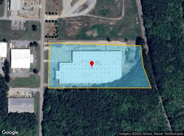
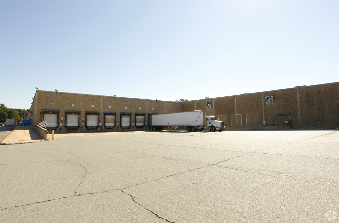
1031 N Redmond Rd
22J-011-00-026-00
PT NE SW BEG SW COR SW N1*23'E2387 7 FT E1320 8'TO C REDMON RD S89*55'E 40 01'TO E R/W RD&POB S1*03'W ON E R/W RD 493 03'S89*55'E1121 51'TO W R/W MOP RR N13*10'W ON RR 138.36'N10 DEG W ON RR 364.34'TO S LN SW N89*55 MIN W 1015.51' TO POB 24 3N 11W
Warehouse
Pulaski
X
Arkansas
05119C0357H
10.82 AC
2023
Outlying Pulaski County
2023
Little Rock/N Little Rock
003604
Little Rock-North Little Rock-Conway, AR
203,943 SF
DEMOGRAPHICS near 1031 N Redmond Rd
1 Mile
3 Mile
5 Mile
2024 Total Population
2,573
28,498
53,517
2029 Population
2,549
28,469
53,506
Pop Growth 2024-2029
(0.93%)
(0.10%)
(0.02%)
Average Age
38
36
38
2024 Total Households
1,013
11,217
21,382
HH Growth 2024-2029
(0.89%)
(0.16%)
(0.07%)
Median Household Inc
$70,406
$43,641
$50,123
Avg Household Size
2.50
2.40
2.40
2024 Avg HH Vehicles
2.00
2.00
2.00
Median Home Value
$170,950
$148,023
$166,873
Median Year Built
1982
1978
1983
Nearby Places
- Restaurants
- Banks
- Shops
- Fitness
- Groceries
PUBLIC TRANSPORTATION
AIRPORT
Bill and Hillary Clinton Ntl/Adams Field
DRIVE
WALK
Distance
Bill and Hillary Clinton Ntl/Adams Field
21 min
16.1 mi
Freight Ports
Port of Shreveport
DRIVE
WALK
Distance
Port of Shreveport
267 min
247.1 mi
Nearby Properties
Address
Land Use
TOTAL SIZE
Lot Size
Zoning
Address
Land Use
TOTAL SIZE
Lot Size
Zoning
47,190 SF
8.09 AC
Address
Land Use
TOTAL SIZE
Lot Size
Zoning
161,890 SF
0.98 AC
Address
Land Use
TOTAL SIZE
Lot Size
Zoning
6,099.88 AC
Address
Land Use
TOTAL SIZE
Lot Size
Zoning
156,907 SF
39.02 AC
Address
Land Use
TOTAL SIZE
Lot Size
Zoning
5,850 SF
21.81 AC
Address
Land Use
TOTAL SIZE
Lot Size
Zoning
53,918 SF
11.26 AC
Address
Land Use
TOTAL SIZE
Lot Size
Zoning
137,320 SF
14.27 AC
Address
Land Use
TOTAL SIZE
Lot Size
Zoning
45,006 SF
6.33 AC
Address
Land Use
TOTAL SIZE
Lot Size
Zoning
37,333 SF
6.43 AC
Address
Land Use
TOTAL SIZE
Lot Size
Zoning
40,226 SF
9.04 AC
Address
Land Use
TOTAL SIZE
Lot Size
Zoning
132,515 SF
10.11 AC
Address
Land Use
TOTAL SIZE
Lot Size
Zoning
71,861 SF
5.91 AC
Address
Land Use
TOTAL SIZE
Lot Size
Zoning
36,642 SF
3.99 AC
Address
Land Use
TOTAL SIZE
Lot Size
Zoning
86,675 SF
4.73 AC
Address
Land Use
TOTAL SIZE
Lot Size
Zoning
78,815 SF
10.71 AC
Address
Land Use
TOTAL SIZE
Lot Size
Zoning
10,318 SF
18.13 AC
Address
Land Use
TOTAL SIZE
Lot Size
Zoning
28,329 SF
10.40 AC
Address
Land Use
TOTAL SIZE
Lot Size
Zoning
81,684 SF
9.18 AC
Address
Land Use
TOTAL SIZE
Lot Size
Zoning
33,668 SF
2.67 AC
Address
Land Use
TOTAL SIZE
Lot Size
Zoning
16,988 SF
9.14 AC
Address
Land Use
TOTAL SIZE
Lot Size
Zoning
36,750 SF
3.50 AC
Address
Land Use
TOTAL SIZE
Lot Size
Zoning
14,005 SF
5.45 AC
Address
Land Use
TOTAL SIZE
Lot Size
Zoning
43,630 SF
12.38 AC
Address
Land Use
TOTAL SIZE
Lot Size
Zoning
12,399 SF
6.12 AC
Address
Land Use
TOTAL SIZE
Lot Size
Zoning
26,640 SF
10.64 AC
Address
Land Use
TOTAL SIZE
Lot Size
Zoning
39,624 SF
6.49 AC
Address
Land Use
TOTAL SIZE
Lot Size
Zoning
125,495 SF
8.54 AC
Address
Land Use
TOTAL SIZE
Lot Size
Zoning
70,790 SF
6.17 AC
Address
Land Use
TOTAL SIZE
Lot Size
Zoning
31,200 SF
4.38 AC
The World's #1 Commercial Real Estate Marketplace
Connect with us
© 2025 CoStar Group
The information above has been obtained from sources believed reliable. While we do not doubt its accuracy we have not verified it and make no guarantee, warranty or representation about it. It is your responsibility to independently confirm its accuracy and completeness. Any projections, opinions, assumptions, or estimates used are for example only and do not represent the current or future performance of the property. The value of this transaction to you depends on tax and other factors which should be evaluated by your tax, financial, and legal advisors. You and your advisors should conduct a careful, independent investigation of the property to determine to your satisfaction the suitability of the property for your needs.