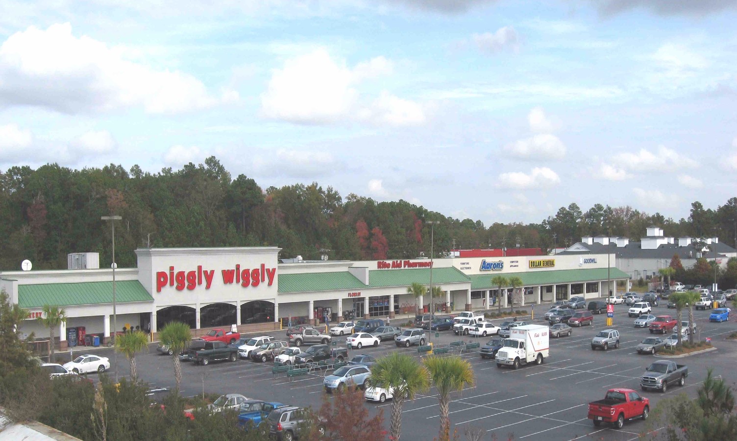
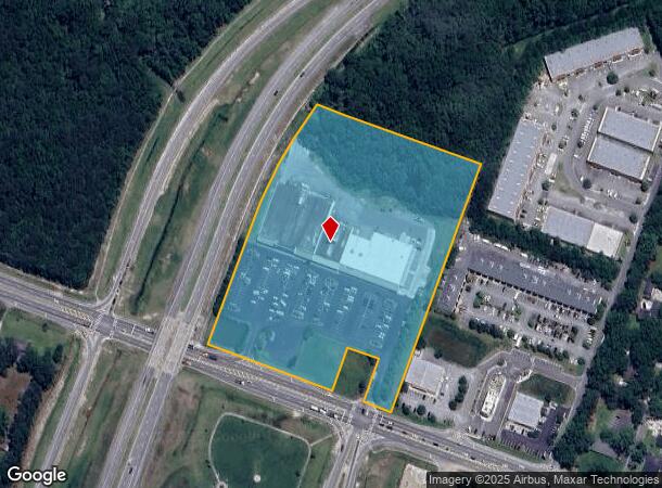
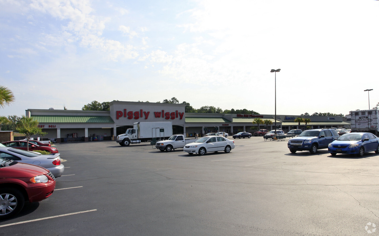
Property Record
1034 Us Highway 80 W, Pooler, GA 31322
NEARBY LISTINGS FOR SALE OR LEASE
Property Detail
1034 Us Highway 80 W
5001801002
Pooler
Communitycenter
PT OF THE POOLER DEVELOPMENT PR OPERTY BEING A PT OF THE MARY S
AE
Chatham
13051C0107H
Georgia
2023
11.06 AC
2024
Bloomingdale/Pooler
010811
Savannah
23,542 SF
Savannah, GA
DEMOGRAPHICS near 1034 Us Highway 80 W
1 Mile
3 Mile
5 Mile
2024 Total Population
2,639
26,799
53,109
2029 Population
2,724
28,128
56,242
Pop Growth 2024-2029
+ 3.22%
+ 4.96%
+ 5.90%
Average Age
42
38
38
2024 Total Households
1,088
10,984
20,677
HH Growth 2024-2029
+ 3.31%
+ 4.84%
+ 5.75%
Median Household Inc
$54,937
$82,359
$84,783
Avg Household Size
2.40
2.40
2.50
2024 Avg HH Vehicles
2.00
2.00
2.00
Median Home Value
$218,308
$235,739
$238,262
Median Year Built
1999
2005
2007
Nearby Places
- Restaurants
- Banks
- Shops
- Fitness
- Groceries
PUBLIC TRANSPORTATION
COMMUTER RAIL
Savannah (Palmetto - Amtrak, Silver Meteor - Amtrak, Silver Star - Amtrak)
DRIVE
WALK
Distance
Savannah (Palmetto - Amtrak, Silver Meteor - Amtrak, Silver Star - Amtrak)
17 min
8.8 mi
AIRPORT
Savannah/Hilton Head International
DRIVE
WALK
Distance
Savannah/Hilton Head International
17 min
7.7 mi
Freight Ports
Georgia Ports - Savannah
DRIVE
WALK
Distance
Georgia Ports - Savannah
19 min
9.8 mi
Nearby Properties
Address
Land Use
TOTAL SIZE
Lot Size
Zoning
Address
Land Use
TOTAL SIZE
Lot Size
Zoning
1,460,340 SF
89.96 AC
RA-1
Address
Land Use
TOTAL SIZE
Lot Size
Zoning
Address
Land Use
TOTAL SIZE
Lot Size
Zoning
Address
Land Use
TOTAL SIZE
Lot Size
Zoning
1,099,220 SF
206.18 AC
I-H
Address
Land Use
TOTAL SIZE
Lot Size
Zoning
71.17 AC
PUD
Address
Land Use
TOTAL SIZE
Lot Size
Zoning
64.07 AC
I-H
Address
Land Use
TOTAL SIZE
Lot Size
Zoning
Address
Land Use
TOTAL SIZE
Lot Size
Zoning
426,547 SF
15.29 AC
Address
Land Use
TOTAL SIZE
Lot Size
Zoning
84.08 AC
PUD
Address
Land Use
TOTAL SIZE
Lot Size
Zoning
56.31 AC
I-1
Address
Land Use
TOTAL SIZE
Lot Size
Zoning
432,965 SF
10.09 AC
Address
Land Use
TOTAL SIZE
Lot Size
Zoning
42,338 SF
65.96 AC
PUD
Address
Land Use
TOTAL SIZE
Lot Size
Zoning
832,000 SF
59.75 AC
I-H
Address
Land Use
TOTAL SIZE
Lot Size
Zoning
49.38 AC
I-1
Address
Land Use
TOTAL SIZE
Lot Size
Zoning
710,881 SF
44.98 AC
I-1
Address
Land Use
TOTAL SIZE
Lot Size
Zoning
57.50 AC
PUD
Address
Land Use
TOTAL SIZE
Lot Size
Zoning
Address
Land Use
TOTAL SIZE
Lot Size
Zoning
43.38 AC
I-H
Address
Land Use
TOTAL SIZE
Lot Size
Zoning
Address
Land Use
TOTAL SIZE
Lot Size
Zoning
4,656 SF
80.38 AC
PUD
Address
Land Use
TOTAL SIZE
Lot Size
Zoning
67.26 AC
I-1
Address
Land Use
TOTAL SIZE
Lot Size
Zoning
24.54 AC
R-3-B
Address
Land Use
TOTAL SIZE
Lot Size
Zoning
4,888 SF
37.80 AC
PUDC
Address
Land Use
TOTAL SIZE
Lot Size
Zoning
17,406 SF
18.27 AC
R-3C
Address
Land Use
TOTAL SIZE
Lot Size
Zoning
36.16 AC
Address
Land Use
TOTAL SIZE
Lot Size
Zoning
35,352 SF
21.22 AC
PUD
Address
Land Use
TOTAL SIZE
Lot Size
Zoning
25,656 SF
23.69 AC
PUDC
Address
Land Use
TOTAL SIZE
Lot Size
Zoning
Address
Land Use
TOTAL SIZE
Lot Size
Zoning
34,404 SF
20 AC
C2
Address
Land Use
TOTAL SIZE
Lot Size
Zoning
22,220 SF
27.20 AC
PUDC
The World's #1 Commercial Real Estate Marketplace
Connect with us
© 2025 CoStar Group
The information above has been obtained from sources believed reliable. While we do not doubt its accuracy we have not verified it and make no guarantee, warranty or representation about it. It is your responsibility to independently confirm its accuracy and completeness. Any projections, opinions, assumptions, or estimates used are for example only and do not represent the current or future performance of the property. The value of this transaction to you depends on tax and other factors which should be evaluated by your tax, financial, and legal advisors. You and your advisors should conduct a careful, independent investigation of the property to determine to your satisfaction the suitability of the property for your needs.