Property Record
1035 Lejune Dr, Springfield, IL 62703
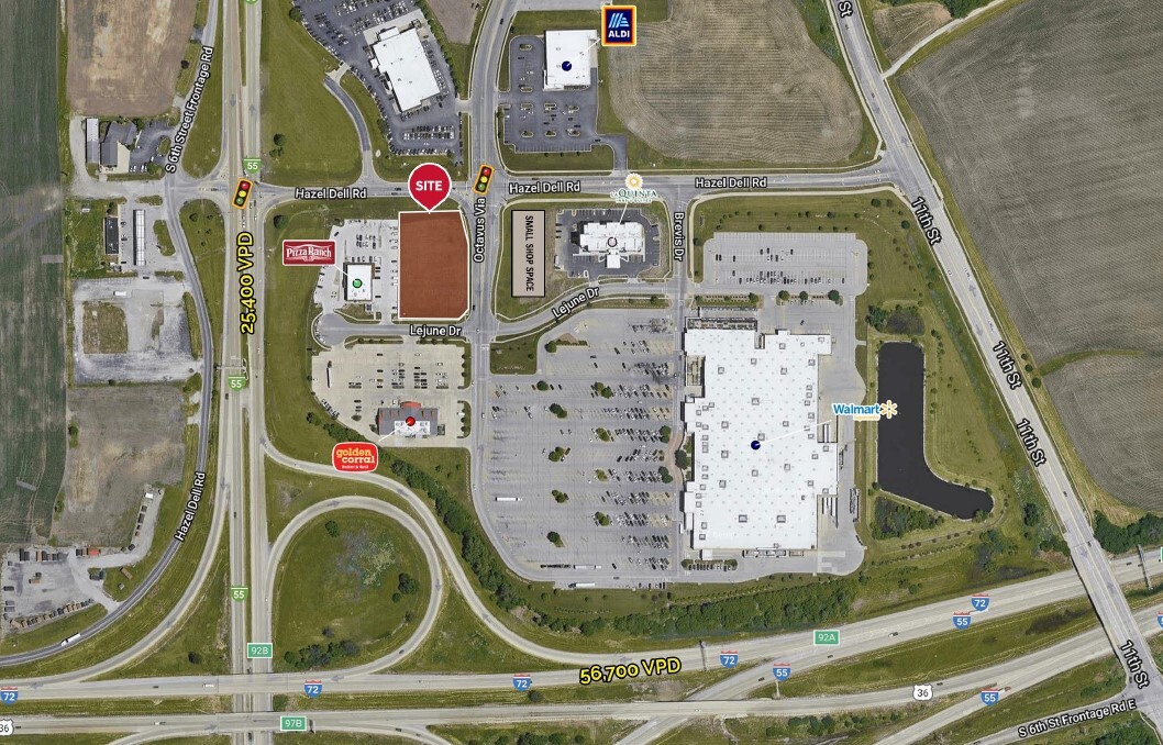
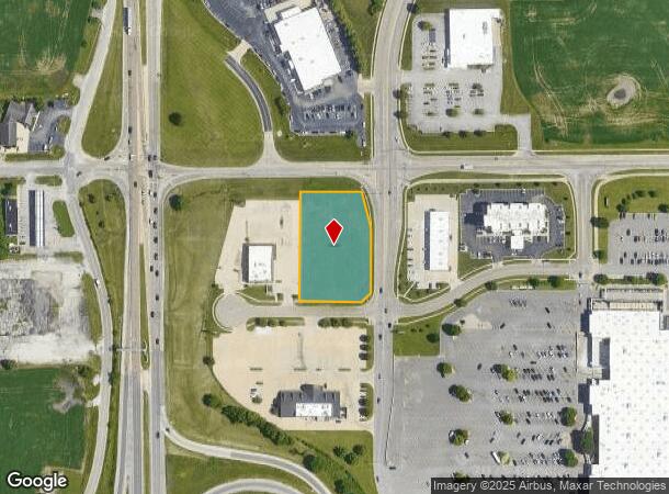
This Property Is For Sale
NEARBY LISTINGS FOR SALE OR LEASE
Property Detail
1035 Lejune Dr
22-15.0-376-005
L 5 ROUTE 66 PLAZA 15-15-5
Commercialacreage
Sangamon
X
Illinois
17167C0410F
1.31 AC
2023
Springfield/Decatur
2023
Other Market Areas
002700
Springfield, IL
DEMOGRAPHICS near 1035 Lejune Dr
1 Mile
3 Mile
5 Mile
2024 Total Population
3,528
43,161
106,065
2029 Population
3,482
42,881
105,557
Pop Growth 2024-2029
(1.30%)
(0.65%)
(0.48%)
Average Age
40
40
41
2024 Total Households
1,475
19,097
47,306
HH Growth 2024-2029
(1.42%)
(0.79%)
(0.54%)
Median Household Inc
$66,214
$57,851
$60,059
Avg Household Size
2.10
2.10
2.10
2024 Avg HH Vehicles
2.00
2.00
2.00
Median Home Value
$123,520
$123,765
$151,597
Median Year Built
1967
1962
1967
Nearby Places
- Restaurants
- Banks
- Shops
- Fitness
- Groceries
PUBLIC TRANSPORTATION
COMMUTER RAIL
Springfield (Lincoln Service - Amtrak, Lincoln Service Missouri River Runner - Amtrak, Texas Eagle - Amtrak)
DRIVE
WALK
Distance
Springfield (Lincoln Service - Amtrak, Lincoln Service Missouri River Runner - Amtrak, Texas Eagle - Amtrak)
11 min
4.4 mi
AIRPORT
Abraham Lincoln Capital
DRIVE
WALK
Distance
Abraham Lincoln Capital
19 min
8.1 mi
Freight Ports
Port Milwaukee
DRIVE
WALK
Distance
Port Milwaukee
318 min
278.4 mi
Nearby Properties
Address
Land Use
TOTAL SIZE
Lot Size
Zoning
Address
Land Use
TOTAL SIZE
Lot Size
Zoning
Address
Land Use
TOTAL SIZE
Lot Size
Zoning
30.02 AC
Address
Land Use
TOTAL SIZE
Lot Size
Zoning
1.05 AC
Address
Land Use
TOTAL SIZE
Lot Size
Zoning
19.94 AC
Address
Land Use
TOTAL SIZE
Lot Size
Zoning
12.88 AC
Address
Land Use
TOTAL SIZE
Lot Size
Zoning
Address
Land Use
TOTAL SIZE
Lot Size
Zoning
Address
Land Use
TOTAL SIZE
Lot Size
Zoning
Address
Land Use
TOTAL SIZE
Lot Size
Zoning
Address
Land Use
TOTAL SIZE
Lot Size
Zoning
10.13 AC
Address
Land Use
TOTAL SIZE
Lot Size
Zoning
Address
Land Use
TOTAL SIZE
Lot Size
Zoning
Address
Land Use
TOTAL SIZE
Lot Size
Zoning
7.80 AC
Address
Land Use
TOTAL SIZE
Lot Size
Zoning
Address
Land Use
TOTAL SIZE
Lot Size
Zoning
Address
Land Use
TOTAL SIZE
Lot Size
Zoning
Address
Land Use
TOTAL SIZE
Lot Size
Zoning
Address
Land Use
TOTAL SIZE
Lot Size
Zoning
12.77 AC
Address
Land Use
TOTAL SIZE
Lot Size
Zoning
Address
Land Use
TOTAL SIZE
Lot Size
Zoning
9.42 AC
Address
Land Use
TOTAL SIZE
Lot Size
Zoning
Address
Land Use
TOTAL SIZE
Lot Size
Zoning
Address
Land Use
TOTAL SIZE
Lot Size
Zoning
6.34 AC
Address
Land Use
TOTAL SIZE
Lot Size
Zoning
Address
Land Use
TOTAL SIZE
Lot Size
Zoning
Address
Land Use
TOTAL SIZE
Lot Size
Zoning
Address
Land Use
TOTAL SIZE
Lot Size
Zoning
5.41 AC
Address
Land Use
TOTAL SIZE
Lot Size
Zoning
4.13 AC
I2
Address
Land Use
TOTAL SIZE
Lot Size
Zoning
Address
Land Use
TOTAL SIZE
Lot Size
Zoning
The World's #1 Commercial Real Estate Marketplace
Connect with us
© 2025 CoStar Group
The information above has been obtained from sources believed reliable. While we do not doubt its accuracy we have not verified it and make no guarantee, warranty or representation about it. It is your responsibility to independently confirm its accuracy and completeness. Any projections, opinions, assumptions, or estimates used are for example only and do not represent the current or future performance of the property. The value of this transaction to you depends on tax and other factors which should be evaluated by your tax, financial, and legal advisors. You and your advisors should conduct a careful, independent investigation of the property to determine to your satisfaction the suitability of the property for your needs.