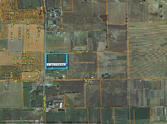
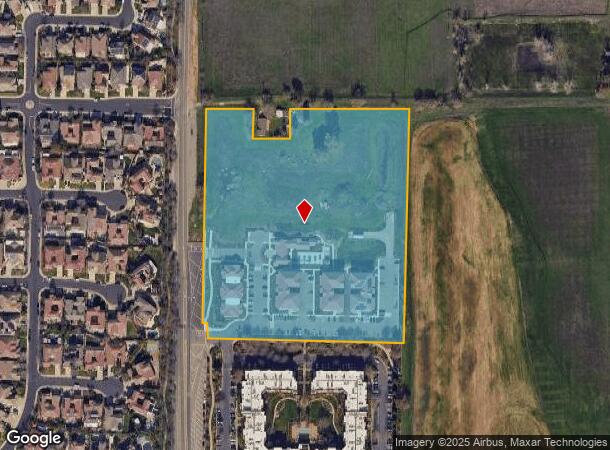
Property Record
10371 Bruceville Rd, Elk Grove, CA 95757

NEARBY LISTINGS FOR SALE OR LEASE
Property Detail
10371 Bruceville Rd
Sacramento--Roseville--Arden-Arcade, CA
H J Goethe Companys
132-0050-034
LOT 1008 OF H J GOETHE COLONY NO 10 EXC S 8 AC AND ALSO EXC POR DESC AS BEG AT PT LOC W 363 FT FROM N E COR OF SD LOT, TH S 91 FT, TH W 112 FT,TH N 91 FT, TH E 112 FT TO P O B EXCL R/W PER 20080414-1780
Apartment
Sacramento
X
California
06067C0318H
1008
2023
8.95 AC
2024
Elk Grove
009652
Sacramento
68,217 SF
DEMOGRAPHICS near 10371 Bruceville Rd
1 Mile
3 Mile
5 Mile
2024 Total Population
11,534
79,031
186,427
2029 Population
12,017
80,109
188,034
Pop Growth 2024-2029
+ 4.19%
+ 1.36%
+ 0.86%
Average Age
38
38
38
2024 Total Households
3,332
24,398
57,693
HH Growth 2024-2029
+ 4.68%
+ 1.33%
+ 0.83%
Median Household Inc
$129,495
$111,337
$108,021
Avg Household Size
3.40
3.20
3.10
2024 Avg HH Vehicles
2.00
2.00
2.00
Median Home Value
$690,172
$580,700
$542,667
Median Year Built
2008
2003
1999
Nearby Places
- Restaurants
- Banks
- Shops
- Fitness
- Groceries
PUBLIC TRANSPORTATION
AIRPORT
Sacramento International
DRIVE
WALK
Distance
Sacramento International
40 min
29.6 mi
Freight Ports
Port of Stockton
DRIVE
WALK
Distance
Port of Stockton
43 min
35.1 mi
Nearby Properties
Address
Land Use
TOTAL SIZE
Lot Size
Zoning
Address
Land Use
TOTAL SIZE
Lot Size
Zoning
468,870 SF
26.55 AC
RD-20
Address
Land Use
TOTAL SIZE
Lot Size
Zoning
265,222 SF
14.42 AC
RD-20
Address
Land Use
TOTAL SIZE
Lot Size
Zoning
7.65 AC
RD-20
Address
Land Use
TOTAL SIZE
Lot Size
Zoning
4.98 AC
RD-20
Address
Land Use
TOTAL SIZE
Lot Size
Zoning
152,217 SF
17.42 AC
SC
Address
Land Use
TOTAL SIZE
Lot Size
Zoning
64,579 SF
5.41 AC
LRSPA
Address
Land Use
TOTAL SIZE
Lot Size
Zoning
192,518 SF
8.97 AC
RD-20
Address
Land Use
TOTAL SIZE
Lot Size
Zoning
105,511 SF
6.67 AC
BP
Address
Land Use
TOTAL SIZE
Lot Size
Zoning
105,511 SF
4.79 AC
BP
Address
Land Use
TOTAL SIZE
Lot Size
Zoning
242,577 SF
0.10 AC
RD-20
Address
Land Use
TOTAL SIZE
Lot Size
Zoning
111,489 SF
4.96 AC
MP
Address
Land Use
TOTAL SIZE
Lot Size
Zoning
195,101 SF
12.21 AC
BP
Address
Land Use
TOTAL SIZE
Lot Size
Zoning
76,090 SF
3.32 AC
RD-25
Address
Land Use
TOTAL SIZE
Lot Size
Zoning
108,843 SF
4.14 AC
RD-30
Address
Land Use
TOTAL SIZE
Lot Size
Zoning
185,300 SF
11.63 AC
RD-20
Address
Land Use
TOTAL SIZE
Lot Size
Zoning
3.88 AC
RD-20
Address
Land Use
TOTAL SIZE
Lot Size
Zoning
221,954 SF
7.71 AC
RD-15
Address
Land Use
TOTAL SIZE
Lot Size
Zoning
4.88 AC
RD-25
Address
Land Use
TOTAL SIZE
Lot Size
Zoning
91,226 SF
10.81 AC
SC
Address
Land Use
TOTAL SIZE
Lot Size
Zoning
83,274 SF
9.14 AC
SC
Address
Land Use
TOTAL SIZE
Lot Size
Zoning
110,372 SF
2.68 AC
BP
Address
Land Use
TOTAL SIZE
Lot Size
Zoning
102,526 SF
4.06 AC
MP
Address
Land Use
TOTAL SIZE
Lot Size
Zoning
65,148 SF
5.77 AC
GC
Address
Land Use
TOTAL SIZE
Lot Size
Zoning
100 SF
50.85 AC
LRSPA
Address
Land Use
TOTAL SIZE
Lot Size
Zoning
42,890 SF
4.38 AC
MP
Address
Land Use
TOTAL SIZE
Lot Size
Zoning
88,408 SF
9.41 AC
SC
Address
Land Use
TOTAL SIZE
Lot Size
Zoning
66,793 SF
2.48 AC
SC
Address
Land Use
TOTAL SIZE
Lot Size
Zoning
68,190 SF
3.75 AC
BP
Address
Land Use
TOTAL SIZE
Lot Size
Zoning
126,924 SF
5.26 AC
RD-25
The World's #1 Commercial Real Estate Marketplace
Connect with us
© 2025 CoStar Group
The information above has been obtained from sources believed reliable. While we do not doubt its accuracy we have not verified it and make no guarantee, warranty or representation about it. It is your responsibility to independently confirm its accuracy and completeness. Any projections, opinions, assumptions, or estimates used are for example only and do not represent the current or future performance of the property. The value of this transaction to you depends on tax and other factors which should be evaluated by your tax, financial, and legal advisors. You and your advisors should conduct a careful, independent investigation of the property to determine to your satisfaction the suitability of the property for your needs.