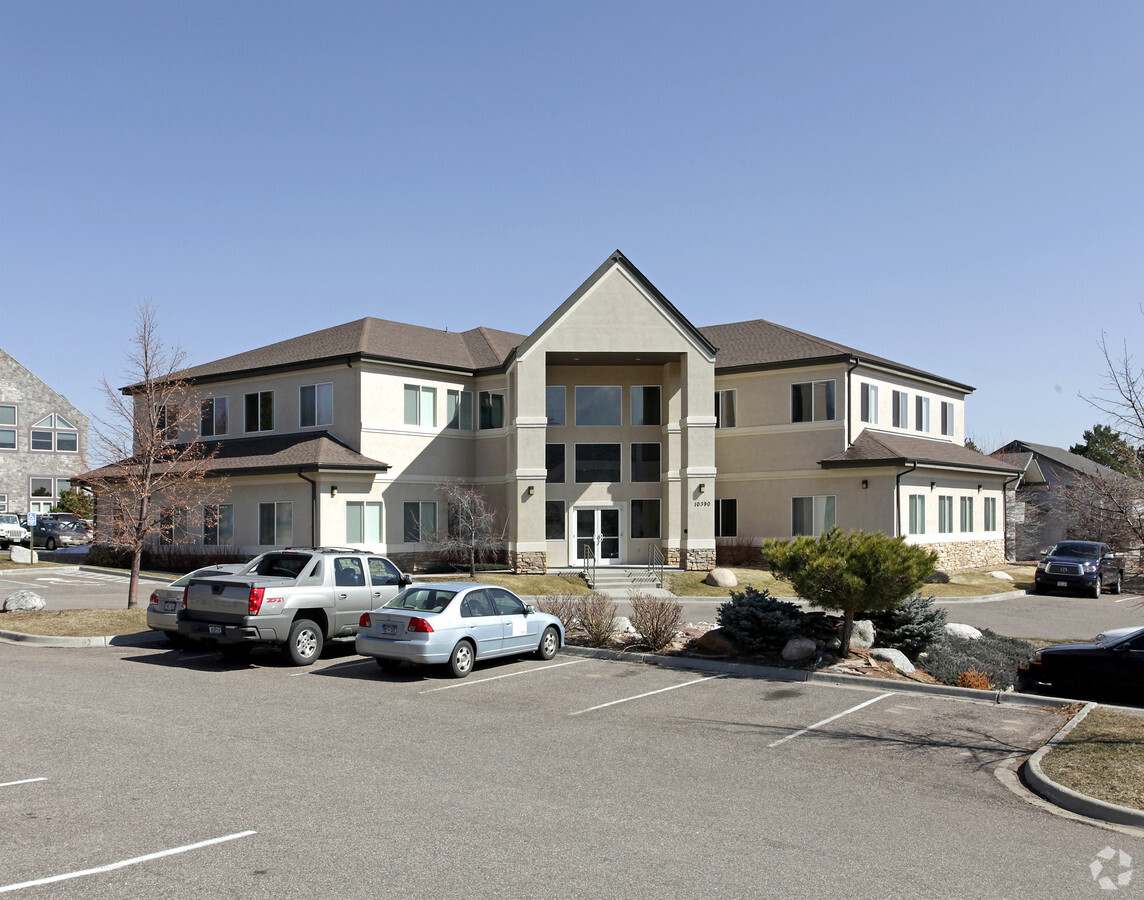
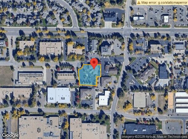
Property Record
10390 Bradford Rd, Littleton, CO 80127


NEARBY LISTINGS FOR SALE OR LEASE
Property Detail
10390 Bradford Rd
Denver-Aurora-Lakewood, CO
Ken Caryl Ranch Plains Ph Viii-B
59-334-11-006
SECTION 33 TOWNSHIP 05 RANGE 69 QTR SE SUBDIVISIONCD 404400 SUBDIVISIONNAME KEN CARYL RANCH PLAINS PH VIII-B BLOCK 005 LOT 0005 SIZE: 37897 TRACT VALUE: .870
Commercialnec
Jefferson
X
Colorado
08059C0403F
5
2023
0.87 AC
2024
Southwest Denver
012024
Denver
12,462 SF
DEMOGRAPHICS near 10390 Bradford Rd
1 Mile
3 Mile
5 Mile
2024 Total Population
11,369
63,349
131,693
2029 Population
11,214
62,176
130,999
Pop Growth 2024-2029
(1.36%)
(1.85%)
(0.53%)
Average Age
42
42
43
2024 Total Households
4,812
24,400
51,580
HH Growth 2024-2029
(1.37%)
(1.95%)
(0.41%)
Median Household Inc
$96,987
$113,246
$111,200
Avg Household Size
2.30
2.50
2.50
2024 Avg HH Vehicles
2.00
2.00
2.00
Median Home Value
$495,583
$563,145
$592,898
Median Year Built
1986
1985
1987
Nearby Places
- Restaurants
- Banks
- Shops
- Fitness
- Groceries
SALE & LEASE HISTORY
LISTING DATE
SALE/LEASE

Mar 04, 2021
For Sale
Nearby Properties
Address
Land Use
TOTAL SIZE
Lot Size
Zoning
Address
Land Use
TOTAL SIZE
Lot Size
Zoning
918 SF
1,492.98 AC
A2
Address
Land Use
TOTAL SIZE
Lot Size
Zoning
895,137 SF
124.99 AC
PD
Address
Land Use
TOTAL SIZE
Lot Size
Zoning
272,246 SF
31.76 AC
PD
Address
Land Use
TOTAL SIZE
Lot Size
Zoning
2,884.97 AC
A1
Address
Land Use
TOTAL SIZE
Lot Size
Zoning
214,066 SF
82.60 AC
PD
Address
Land Use
TOTAL SIZE
Lot Size
Zoning
392,710 SF
21.22 AC
PD
Address
Land Use
TOTAL SIZE
Lot Size
Zoning
178,421 SF
12.31 AC
PD
Address
Land Use
TOTAL SIZE
Lot Size
Zoning
150,951 SF
17.90 AC
PD
Address
Land Use
TOTAL SIZE
Lot Size
Zoning
101,699 SF
10.34 AC
Address
Land Use
TOTAL SIZE
Lot Size
Zoning
297,003 SF
26.77 AC
PD
Address
Land Use
TOTAL SIZE
Lot Size
Zoning
119,540 SF
10.67 AC
C1
Address
Land Use
TOTAL SIZE
Lot Size
Zoning
218,391 SF
9.73 AC
PD
Address
Land Use
TOTAL SIZE
Lot Size
Zoning
120,766 SF
20.56 AC
PD
Address
Land Use
TOTAL SIZE
Lot Size
Zoning
100,550 SF
7.72 AC
PD
Address
Land Use
TOTAL SIZE
Lot Size
Zoning
124,224 SF
1.56 AC
Address
Land Use
TOTAL SIZE
Lot Size
Zoning
107,693 SF
9.17 AC
PD
Address
Land Use
TOTAL SIZE
Lot Size
Zoning
187,987 SF
10.06 AC
PD
Address
Land Use
TOTAL SIZE
Lot Size
Zoning
12,367 SF
4.18 AC
Address
Land Use
TOTAL SIZE
Lot Size
Zoning
68,373 SF
7.97 AC
C1
Address
Land Use
TOTAL SIZE
Lot Size
Zoning
59,816 SF
16.92 AC
Address
Land Use
TOTAL SIZE
Lot Size
Zoning
58,550 SF
9.67 AC
Address
Land Use
TOTAL SIZE
Lot Size
Zoning
105,392 SF
7.44 AC
Address
Land Use
TOTAL SIZE
Lot Size
Zoning
28,533 SF
11.07 AC
Address
Land Use
TOTAL SIZE
Lot Size
Zoning
71,091 SF
4.93 AC
PD
Address
Land Use
TOTAL SIZE
Lot Size
Zoning
82,765 SF
4.84 AC
PD
Address
Land Use
TOTAL SIZE
Lot Size
Zoning
137,398 SF
3.62 AC
Address
Land Use
TOTAL SIZE
Lot Size
Zoning
74,322 SF
7.87 AC
Address
Land Use
TOTAL SIZE
Lot Size
Zoning
104,984 SF
3.11 AC
Address
Land Use
TOTAL SIZE
Lot Size
Zoning
36,847 SF
3.02 AC
PD
Address
Land Use
TOTAL SIZE
Lot Size
Zoning
61,038 SF
8.19 AC
The World's #1 Commercial Real Estate Marketplace
Connect with us
© 2025 CoStar Group
The information above has been obtained from sources believed reliable. While we do not doubt its accuracy we have not verified it and make no guarantee, warranty or representation about it. It is your responsibility to independently confirm its accuracy and completeness. Any projections, opinions, assumptions, or estimates used are for example only and do not represent the current or future performance of the property. The value of this transaction to you depends on tax and other factors which should be evaluated by your tax, financial, and legal advisors. You and your advisors should conduct a careful, independent investigation of the property to determine to your satisfaction the suitability of the property for your needs.