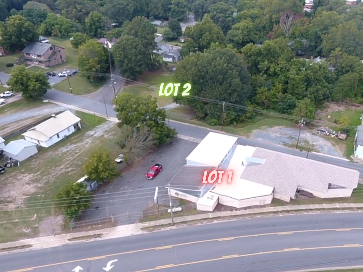
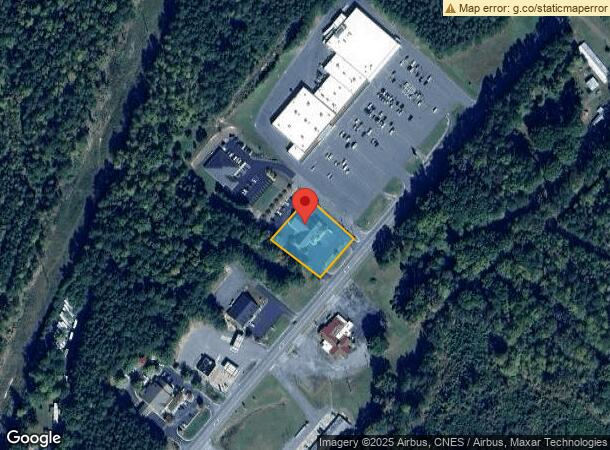
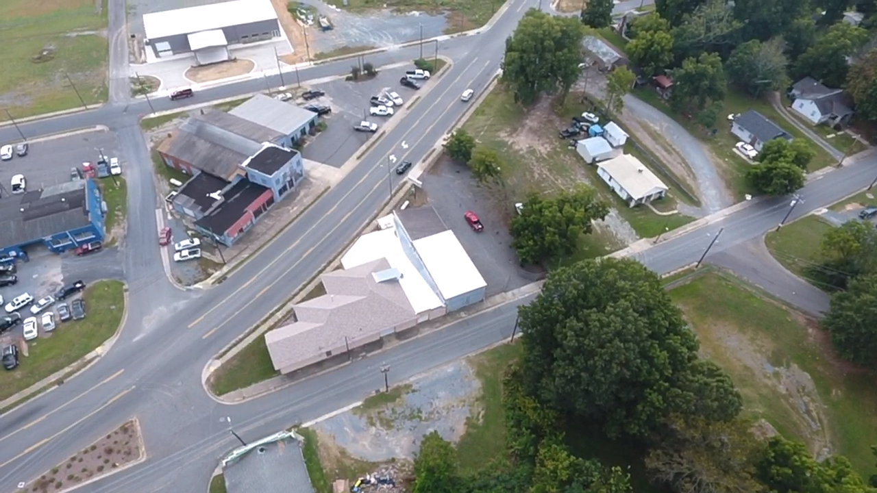
Property Record
1040 Albemarle Rd, Troy, NC 27371
NEARBY LISTINGS FOR SALE OR LEASE
Property Detail
1040 Albemarle Rd
7528-19-72-3045
First Bank
Financialbuilding
FIRST BANK MCRAE
X
Montgomery
3710752800J
North Carolina
2023
0.91 AC
2024
North Carolina Southeast Area
960202
Other Market Areas
4,888 SF
DEMOGRAPHICS near 1040 Albemarle Rd
1 Mile
3 Mile
5 Mile
2024 Total Population
714
4,415
6,339
2029 Population
709
4,418
6,326
Pop Growth 2024-2029
(0.70%)
+ 0.07%
(0.21%)
Average Age
40
40
41
2024 Total Households
298
1,699
2,417
HH Growth 2024-2029
(1.34%)
(0.35%)
(0.66%)
Median Household Inc
$40,179
$44,367
$44,873
Avg Household Size
2.30
2.40
2.40
2024 Avg HH Vehicles
2.00
2.00
2.00
Median Home Value
$151,960
$144,869
$143,323
Median Year Built
1971
1973
1975
Nearby Places
- Restaurants
- Banks
- Shops
- Fitness
- Groceries
SALE & LEASE HISTORY
LISTING DATE
SALE/LEASE

Oct 06, 2021
For Sale
Nearby Properties
Address
Land Use
TOTAL SIZE
Lot Size
Zoning
Address
Land Use
TOTAL SIZE
Lot Size
Zoning
126,675 SF
6.83 AC
INDUSTRIAL
Address
Land Use
TOTAL SIZE
Lot Size
Zoning
57,410 SF
46.91 AC
SCHOOL
Address
Land Use
TOTAL SIZE
Lot Size
Zoning
66,913 SF
59.61 AC
SCHOOL
Address
Land Use
TOTAL SIZE
Lot Size
Zoning
80,056 SF
55.12 AC
SCHOOL
Address
Land Use
TOTAL SIZE
Lot Size
Zoning
44,307 SF
10.65 AC
SCHOOL
Address
Land Use
TOTAL SIZE
Lot Size
Zoning
44,501 SF
2.04 AC
Address
Land Use
TOTAL SIZE
Lot Size
Zoning
90,592 SF
6.62 AC
Address
Land Use
TOTAL SIZE
Lot Size
Zoning
44,344 SF
15.72 AC
SCHOOL
Address
Land Use
TOTAL SIZE
Lot Size
Zoning
10,840 SF
18.83 AC
CHURCH
Address
Land Use
TOTAL SIZE
Lot Size
Zoning
36,736 SF
1.60 AC
Address
Land Use
TOTAL SIZE
Lot Size
Zoning
69,728 SF
8.08 AC
Address
Land Use
TOTAL SIZE
Lot Size
Zoning
22,858 SF
1.83 AC
CHURCH
Address
Land Use
TOTAL SIZE
Lot Size
Zoning
39,200 SF
8.10 AC
Address
Land Use
TOTAL SIZE
Lot Size
Zoning
16,753 SF
9.49 AC
Address
Land Use
TOTAL SIZE
Lot Size
Zoning
5,080 SF
0.24 AC
Address
Land Use
TOTAL SIZE
Lot Size
Zoning
97,235 SF
9.81 AC
INDUSTRIAL
Address
Land Use
TOTAL SIZE
Lot Size
Zoning
3,200 SF
13 AC
Address
Land Use
TOTAL SIZE
Lot Size
Zoning
1,372.01 AC
Address
Land Use
TOTAL SIZE
Lot Size
Zoning
19,677 SF
0.36 AC
Address
Land Use
TOTAL SIZE
Lot Size
Zoning
6,606 SF
7.61 AC
APARTMENTS
Address
Land Use
TOTAL SIZE
Lot Size
Zoning
26,848 SF
0.83 AC
CHURCH
Address
Land Use
TOTAL SIZE
Lot Size
Zoning
6,580 SF
8.85 AC
APARTMENTS
Address
Land Use
TOTAL SIZE
Lot Size
Zoning
5,796 SF
18.90 AC
Address
Land Use
TOTAL SIZE
Lot Size
Zoning
21,960 SF
18.79 AC
Address
Land Use
TOTAL SIZE
Lot Size
Zoning
18,270 SF
8.23 AC
Address
Land Use
TOTAL SIZE
Lot Size
Zoning
36,238 SF
3.05 AC
Address
Land Use
TOTAL SIZE
Lot Size
Zoning
15,174 SF
16.14 AC
Address
Land Use
TOTAL SIZE
Lot Size
Zoning
9,000 SF
0.89 AC
FIRE STATI
Address
Land Use
TOTAL SIZE
Lot Size
Zoning
5,679 SF
2 AC
BANK
Address
Land Use
TOTAL SIZE
Lot Size
Zoning
3,488 SF
2.01 AC
FAST FOOD
The World's #1 Commercial Real Estate Marketplace
Connect with us
© 2025 CoStar Group
The information above has been obtained from sources believed reliable. While we do not doubt its accuracy we have not verified it and make no guarantee, warranty or representation about it. It is your responsibility to independently confirm its accuracy and completeness. Any projections, opinions, assumptions, or estimates used are for example only and do not represent the current or future performance of the property. The value of this transaction to you depends on tax and other factors which should be evaluated by your tax, financial, and legal advisors. You and your advisors should conduct a careful, independent investigation of the property to determine to your satisfaction the suitability of the property for your needs.