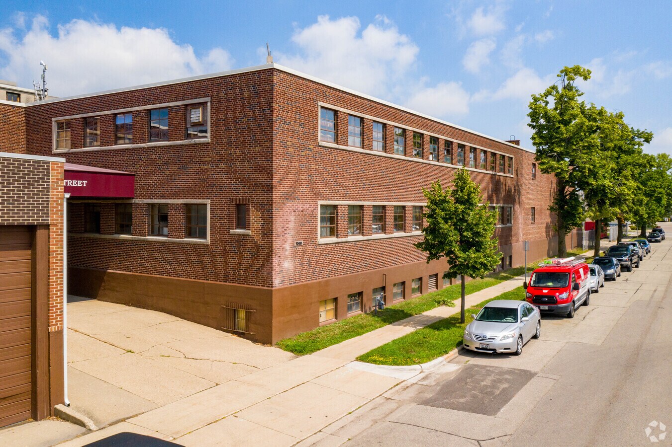
Property Record
1002 E Main St, Stoughton, WI 53589


Current Lease Availabilities
NEARBY LISTINGS FOR SALE OR LEASE
Property Detail
1002 E Main St
Madison, WI
Original Plat, Aka Farwells Replat, Blk
0709-131-1701-0
ORIGINAL PLAT, AKA FARWELLS REPLAT, BLK 171, LOTS 10 THRU 17 AND SE 25 FT LOTS 2 THRU 9.
Commercialnec
Dane
X
Wisconsin
55025C0428G
10
2023
2.30 AC
2023
Central Campus
012201
Milwaukee/Madison
8,100 SF
DEMOGRAPHICS near 1002 E Main St
1 Mile
3 Mile
5 Mile
2024 Total Population
18,970
105,963
202,144
2029 Population
19,553
108,987
208,515
Pop Growth 2024-2029
+ 3.07%
+ 2.85%
+ 3.15%
Average Age
35
34
36
2024 Total Households
10,774
48,283
90,692
HH Growth 2024-2029
+ 3.14%
+ 3.21%
+ 3.39%
Median Household Inc
$63,604
$52,841
$60,737
Avg Household Size
1.70
1.90
2.00
2024 Avg HH Vehicles
1.00
1.00
1.00
Median Home Value
$393,031
$322,869
$302,379
Median Year Built
1961
1963
1970
Nearby Places
- Restaurants
- Banks
- Shops
- Fitness
- Groceries
PUBLIC TRANSPORTATION
AIRPORT
Dane County Regional/Truax Field
DRIVE
WALK
Distance
Dane County Regional/Truax Field
8 min
4.4 mi
Freight Ports
Port Milwaukee
DRIVE
WALK
Distance
Port Milwaukee
93 min
78.5 mi
Nearby Properties
Address
Land Use
TOTAL SIZE
Lot Size
Zoning
Address
Land Use
TOTAL SIZE
Lot Size
Zoning
484,764 SF
1.62 AC
DC
Address
Land Use
TOTAL SIZE
Lot Size
Zoning
395,505 SF
0.99 AC
UMX
Address
Land Use
TOTAL SIZE
Lot Size
Zoning
466,963 SF
761.23 AC
PD
Address
Land Use
TOTAL SIZE
Lot Size
Zoning
461,454 SF
3.37 AC
CC-T
Address
Land Use
TOTAL SIZE
Lot Size
Zoning
463,006 SF
1.42 AC
UMX
Address
Land Use
TOTAL SIZE
Lot Size
Zoning
169,224 SF
5.49 AC
CC-T
Address
Land Use
TOTAL SIZE
Lot Size
Zoning
208,251 SF
414.76 AC
PD
Address
Land Use
TOTAL SIZE
Lot Size
Zoning
251,632 SF
3.88 AC
TE
Address
Land Use
TOTAL SIZE
Lot Size
Zoning
421,021 SF
1.30 AC
DC
Address
Land Use
TOTAL SIZE
Lot Size
Zoning
230,268 SF
0.87 AC
UMX
Address
Land Use
TOTAL SIZE
Lot Size
Zoning
296,708 SF
1 AC
TE
Address
Land Use
TOTAL SIZE
Lot Size
Zoning
269,675 SF
2.25 AC
TR-U2
Address
Land Use
TOTAL SIZE
Lot Size
Zoning
183,407 SF
2.71 AC
PD
Address
Land Use
TOTAL SIZE
Lot Size
Zoning
211,457 SF
329.04 AC
PD
Address
Land Use
TOTAL SIZE
Lot Size
Zoning
230,504 SF
0.76 AC
PD
Address
Land Use
TOTAL SIZE
Lot Size
Zoning
14,229 SF
0.50 AC
DC
Address
Land Use
TOTAL SIZE
Lot Size
Zoning
172,984 SF
1.59 AC
PD
Address
Land Use
TOTAL SIZE
Lot Size
Zoning
182,821 SF
1.19 AC
PD
Address
Land Use
TOTAL SIZE
Lot Size
Zoning
160,531 SF
0.41 AC
UMX
Address
Land Use
TOTAL SIZE
Lot Size
Zoning
42,240 SF
0.98 AC
DC
Address
Land Use
TOTAL SIZE
Lot Size
Zoning
216,017 SF
3.35 AC
TE
Address
Land Use
TOTAL SIZE
Lot Size
Zoning
247,984 SF
1 AC
DC
Address
Land Use
TOTAL SIZE
Lot Size
Zoning
207,221 SF
0.60 AC
UMX
Address
Land Use
TOTAL SIZE
Lot Size
Zoning
148,747 SF
0.83 AC
TE
Address
Land Use
TOTAL SIZE
Lot Size
Zoning
197,046 SF
TE
Address
Land Use
TOTAL SIZE
Lot Size
Zoning
2.03 AC
Address
Land Use
TOTAL SIZE
Lot Size
Zoning
169,491 SF
0.79 AC
HIS-L
Address
Land Use
TOTAL SIZE
Lot Size
Zoning
115,920 SF
2.38 AC
TE
Address
Land Use
TOTAL SIZE
Lot Size
Zoning
192,840 SF
0.37 AC
DC
Address
Land Use
TOTAL SIZE
Lot Size
Zoning
2,454 SF
0.40 AC
PD
The World's #1 Commercial Real Estate Marketplace
Connect with us
© 2025 CoStar Group
The information above has been obtained from sources believed reliable. While we do not doubt its accuracy we have not verified it and make no guarantee, warranty or representation about it. It is your responsibility to independently confirm its accuracy and completeness. Any projections, opinions, assumptions, or estimates used are for example only and do not represent the current or future performance of the property. The value of this transaction to you depends on tax and other factors which should be evaluated by your tax, financial, and legal advisors. You and your advisors should conduct a careful, independent investigation of the property to determine to your satisfaction the suitability of the property for your needs.