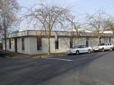
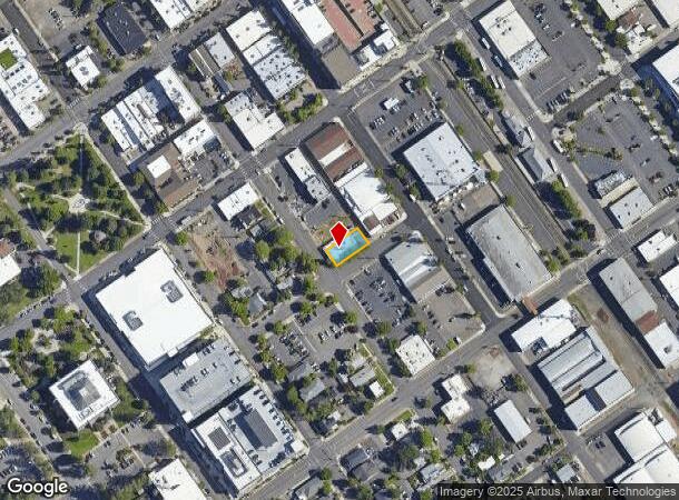
Property Record
130 W 9Th St, Medford, OR 97501
NEARBY LISTINGS FOR SALE OR LEASE
Property Detail
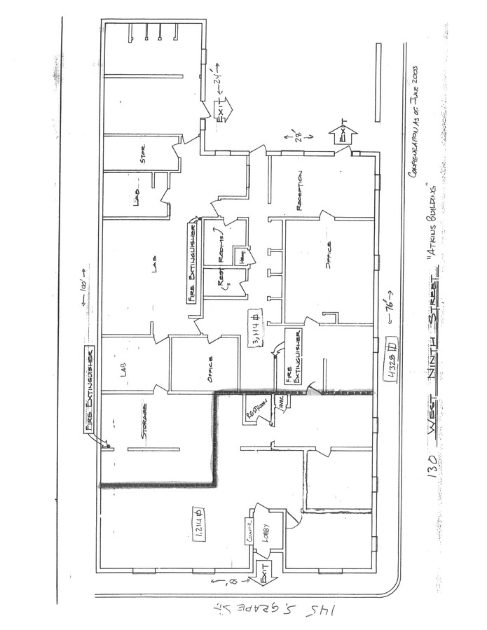
130 W 9Th St
10370361
City Of Medford
Commercialbuilding
Jackson
X
Oregon
41029C1978F
18
2023
0.11 AC
2024
Downtown Medford
000100
Other Market Areas
4,236 SF
Medford, OR
DEMOGRAPHICS near 130 W 9Th St
1 Mile
3 Mile
5 Mile
2024 Total Population
15,530
76,212
120,210
2029 Population
15,217
75,577
119,550
Pop Growth 2024-2029
(2.02%)
(0.83%)
(0.55%)
Average Age
37
41
42
2024 Total Households
6,220
30,350
47,949
HH Growth 2024-2029
(2.04%)
(0.86%)
(0.61%)
Median Household Inc
$41,674
$59,037
$64,361
Avg Household Size
2.30
2.40
2.40
2024 Avg HH Vehicles
2.00
2.00
2.00
Median Home Value
$260,427
$331,663
$349,251
Median Year Built
1952
1977
1983
Nearby Places
- Restaurants
- Banks
- Shops
- Fitness
- Groceries
PUBLIC TRANSPORTATION
AIRPORT
Rogue Valley International - Medford
DRIVE
WALK
Distance
Rogue Valley International - Medford
9 min
3.8 mi
Freight Ports
Port of Coos Bay, OR
DRIVE
WALK
Distance
Port of Coos Bay, OR
219 min
166.0 mi
SALE & LEASE HISTORY
LISTING DATE
SALE/LEASE

Jun 10, 2022
For Sale
Nearby Properties
Address
Land Use
TOTAL SIZE
Lot Size
Zoning
Address
Land Use
TOTAL SIZE
Lot Size
Zoning
674,760 SF
104.26 AC
SFR-4
Address
Land Use
TOTAL SIZE
Lot Size
Zoning
674,760 SF
104.26 AC
SFR-4
Address
Land Use
TOTAL SIZE
Lot Size
Zoning
37.16 AC
RR-5
Address
Land Use
TOTAL SIZE
Lot Size
Zoning
762,720 SF
16.25 AC
C-S/P
Address
Land Use
TOTAL SIZE
Lot Size
Zoning
36,606 SF
2.20 AC
C-S/P
Address
Land Use
TOTAL SIZE
Lot Size
Zoning
291.02 AC
I-L
Address
Land Use
TOTAL SIZE
Lot Size
Zoning
249,867 SF
61.31 AC
SFR-4
Address
Land Use
TOTAL SIZE
Lot Size
Zoning
22.07 AC
GI
Address
Land Use
TOTAL SIZE
Lot Size
Zoning
196,384 SF
4.80 AC
C-S/P
Address
Land Use
TOTAL SIZE
Lot Size
Zoning
77,354 SF
8.28 AC
SFR-4
Address
Land Use
TOTAL SIZE
Lot Size
Zoning
153,140 SF
14.93 AC
SFR-10
Address
Land Use
TOTAL SIZE
Lot Size
Zoning
31.96 AC
GI
Address
Land Use
TOTAL SIZE
Lot Size
Zoning
11,180 SF
1.58 AC
MFR-20
Address
Land Use
TOTAL SIZE
Lot Size
Zoning
177,106 SF
16.28 AC
C-C
Address
Land Use
TOTAL SIZE
Lot Size
Zoning
531,599 SF
26.34 AC
C-R
Address
Land Use
TOTAL SIZE
Lot Size
Zoning
176,910 SF
17.78 AC
C-R
Address
Land Use
TOTAL SIZE
Lot Size
Zoning
30.50 AC
SFR-4
Address
Land Use
TOTAL SIZE
Lot Size
Zoning
85,610 SF
1.78 AC
C-C
Address
Land Use
TOTAL SIZE
Lot Size
Zoning
147,839 SF
15.43 AC
C-R
Address
Land Use
TOTAL SIZE
Lot Size
Zoning
81.70 AC
LI
Address
Land Use
TOTAL SIZE
Lot Size
Zoning
1,126 SF
4.89 AC
SFR-4
Address
Land Use
TOTAL SIZE
Lot Size
Zoning
88,434 SF
12.10 AC
I-L
Address
Land Use
TOTAL SIZE
Lot Size
Zoning
31,338 SF
4.41 AC
C-R
Address
Land Use
TOTAL SIZE
Lot Size
Zoning
3.54 AC
MFR-20
Address
Land Use
TOTAL SIZE
Lot Size
Zoning
12,544 SF
16.70 AC
C-R
Address
Land Use
TOTAL SIZE
Lot Size
Zoning
5.22 AC
MFR-30
Address
Land Use
TOTAL SIZE
Lot Size
Zoning
212,477 SF
13.74 AC
I-L
Address
Land Use
TOTAL SIZE
Lot Size
Zoning
6,140 SF
0.84 AC
C-C
Address
Land Use
TOTAL SIZE
Lot Size
Zoning
3,600 SF
0.50 AC
I-G
Address
Land Use
TOTAL SIZE
Lot Size
Zoning
109,042 SF
7.06 AC
C-R
The World's #1 Commercial Real Estate Marketplace
Connect with us
© 2025 CoStar Group
The information above has been obtained from sources believed reliable. While we do not doubt its accuracy we have not verified it and make no guarantee, warranty or representation about it. It is your responsibility to independently confirm its accuracy and completeness. Any projections, opinions, assumptions, or estimates used are for example only and do not represent the current or future performance of the property. The value of this transaction to you depends on tax and other factors which should be evaluated by your tax, financial, and legal advisors. You and your advisors should conduct a careful, independent investigation of the property to determine to your satisfaction the suitability of the property for your needs.