Property Record
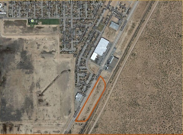
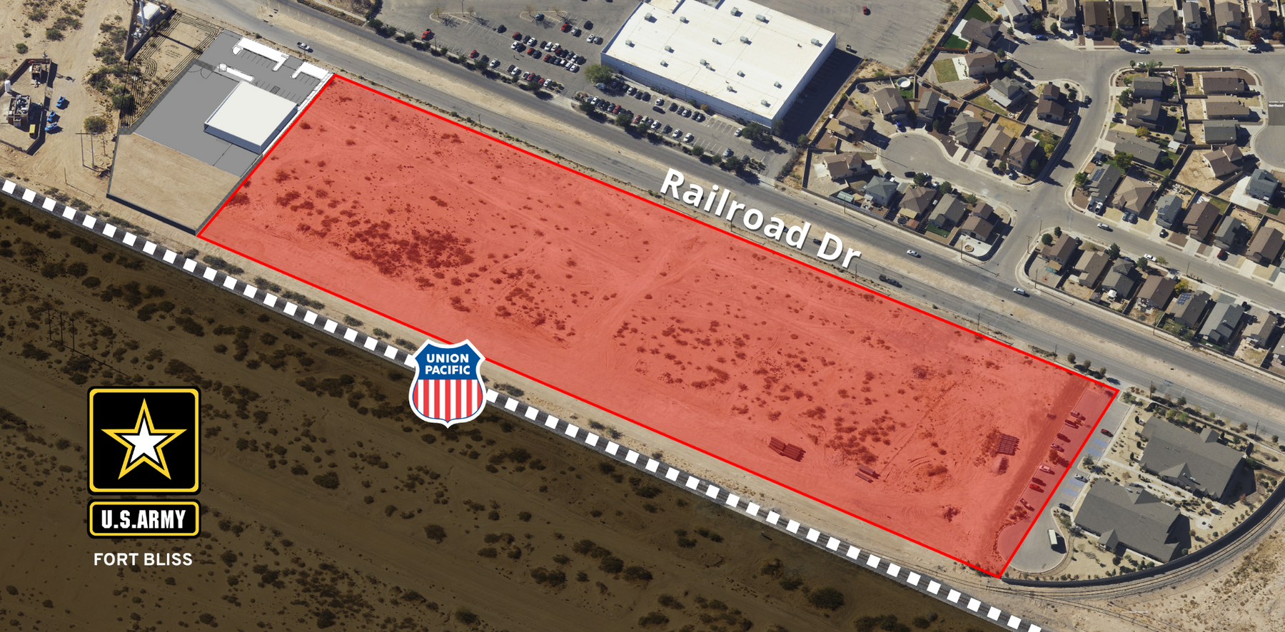
10400 Railroad Dr, El Paso, TX 79924
NEARBY LISTINGS FOR SALE OR LEASE
Property Detail
10400 Railroad Dr
El Paso
W F F Industries Park #1 Rpl A
El Paso, TX
3 W F F INDUSTRIES PARK #1 RPL A 2 (EXC WLY PT) (16051.86 SQ FT)
W220-999-0030-1505
El Paso
Commercialnec
Texas
2023
2
2023
2.50 AC
000208
Northeast
18,536 SF
DEMOGRAPHICS near 10400 Railroad Dr
1 Mile
3 Mile
5 Mile
2024 Total Population
4,312
53,857
94,442
2029 Population
4,367
54,315
95,134
Pop Growth 2024-2029
+ 1.28%
+ 0.85%
+ 0.73%
Average Age
34
35
36
2024 Total Households
1,437
19,013
33,858
HH Growth 2024-2029
+ 1.32%
+ 0.91%
+ 0.82%
Median Household Inc
$48,994
$53,106
$52,277
Avg Household Size
2.90
2.80
2.70
2024 Avg HH Vehicles
2.00
2.00
2.00
Median Home Value
$131,818
$131,732
$138,412
Median Year Built
1993
1983
1982
Nearby Places
- Restaurants
- Banks
- Shops
- Fitness
- Groceries
PUBLIC TRANSPORTATION
AIRPORT
El Paso International
DRIVE
WALK
Distance
El Paso International
25 min
12.8 mi
Freight Ports
Port of Corpus Christi
DRIVE
WALK
Distance
Port of Corpus Christi
690 min
700.7 mi
SALE & LEASE HISTORY
LISTING DATE
SALE/LEASE

Sep 24, 2016
For Sale
Sep 24, 2016
For Sale
Nearby Properties
Address
Land Use
TOTAL SIZE
Lot Size
Zoning
Address
Land Use
TOTAL SIZE
Lot Size
Zoning
117,210 SF
8.55 AC
R4
Address
Land Use
TOTAL SIZE
Lot Size
Zoning
315,450 SF
22.17 AC
M1
Address
Land Use
TOTAL SIZE
Lot Size
Zoning
148,277 SF
17.14 AC
R4
Address
Land Use
TOTAL SIZE
Lot Size
Zoning
263,488 SF
13.88 AC
R3
Address
Land Use
TOTAL SIZE
Lot Size
Zoning
123,824 SF
3.85 AC
A3
Address
Land Use
TOTAL SIZE
Lot Size
Zoning
76,082 SF
13.59 AC
Address
Land Use
TOTAL SIZE
Lot Size
Zoning
26,276 SF
1.52 AC
Address
Land Use
TOTAL SIZE
Lot Size
Zoning
424,325 SF
M1
Address
Land Use
TOTAL SIZE
Lot Size
Zoning
468,270 SF
60 AC
M1
Address
Land Use
TOTAL SIZE
Lot Size
Zoning
46,318 SF
4.92 AC
C3
Address
Land Use
TOTAL SIZE
Lot Size
Zoning
102,026 SF
5.90 AC
M1
Address
Land Use
TOTAL SIZE
Lot Size
Zoning
91,288 SF
14 AC
C1
Address
Land Use
TOTAL SIZE
Lot Size
Zoning
144,711 SF
10.50 AC
M1S
Address
Land Use
TOTAL SIZE
Lot Size
Zoning
113,898 SF
8.88 AC
M1
Address
Land Use
TOTAL SIZE
Lot Size
Zoning
75,857 SF
C1
Address
Land Use
TOTAL SIZE
Lot Size
Zoning
256,048 SF
36.89 AC
R4
Address
Land Use
TOTAL SIZE
Lot Size
Zoning
77.84 AC
M1
Address
Land Use
TOTAL SIZE
Lot Size
Zoning
129,076 SF
7.61 AC
C3C
Address
Land Use
TOTAL SIZE
Lot Size
Zoning
39,270 SF
2.52 AC
C3
Address
Land Use
TOTAL SIZE
Lot Size
Zoning
57,232 SF
11.16 AC
R4
Address
Land Use
TOTAL SIZE
Lot Size
Zoning
241,802 SF
9.81 AC
M1
Address
Land Use
TOTAL SIZE
Lot Size
Zoning
108,272 SF
7.21 AC
C1S
Address
Land Use
TOTAL SIZE
Lot Size
Zoning
318,722 SF
50 AC
M1
Address
Land Use
TOTAL SIZE
Lot Size
Zoning
40 AC
R4
Address
Land Use
TOTAL SIZE
Lot Size
Zoning
127,112 SF
7.24 AC
A2
Address
Land Use
TOTAL SIZE
Lot Size
Zoning
84,149 SF
6.52 AC
A2
Address
Land Use
TOTAL SIZE
Lot Size
Zoning
133,498 SF
10.04 AC
C1
Address
Land Use
TOTAL SIZE
Lot Size
Zoning
37,387 SF
5 AC
R4
Address
Land Use
TOTAL SIZE
Lot Size
Zoning
35,842 SF
39.90 AC
R3
Address
Land Use
TOTAL SIZE
Lot Size
Zoning
89,321 SF
7.28 AC
C4
The World's #1 Commercial Real Estate Marketplace
Connect with us
© 2025 CoStar Group
The information above has been obtained from sources believed reliable. While we do not doubt its accuracy we have not verified it and make no guarantee, warranty or representation about it. It is your responsibility to independently confirm its accuracy and completeness. Any projections, opinions, assumptions, or estimates used are for example only and do not represent the current or future performance of the property. The value of this transaction to you depends on tax and other factors which should be evaluated by your tax, financial, and legal advisors. You and your advisors should conduct a careful, independent investigation of the property to determine to your satisfaction the suitability of the property for your needs.