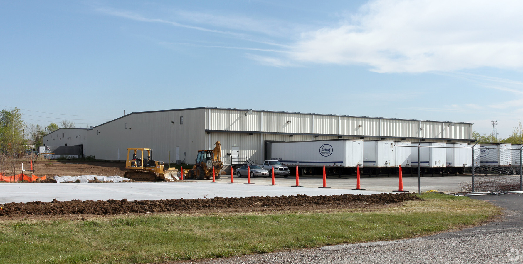
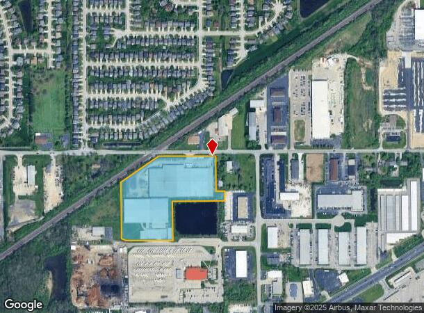
Property Record
10401 E 59Th St, Indianapolis, IN 46236
NEARBY LISTINGS FOR SALE OR LEASE
Property Detail
10401 E 59Th St
Indianapolis-Carmel-Anderson, IN
PT SW1/4 S4 T16 R5 BEG 75? W OF NE COR P.O.B. S330? E75? S83.61? W454.32? S339.16? W383.15? NW50.28? NW14.93? N476.68? NEIRR467.36? E433.94? TO BEG
49-08-04-125-011.000-407
Marion
Lightindustrial
Indiana
2023
10.29 AC
2023
Fort Ben
330204
Indianapolis
5,430 SF
DEMOGRAPHICS near 10401 E 59Th St
1 Mile
3 Mile
5 Mile
2024 Total Population
6,343
66,091
161,297
2029 Population
6,205
65,628
160,944
Pop Growth 2024-2029
(2.18%)
(0.70%)
(0.22%)
Average Age
39
36
37
2024 Total Households
2,476
24,659
62,561
HH Growth 2024-2029
(2.02%)
(0.73%)
(0.32%)
Median Household Inc
$65,567
$58,284
$63,037
Avg Household Size
2.50
2.60
2.50
2024 Avg HH Vehicles
2.00
2.00
2.00
Median Home Value
$166,880
$175,676
$201,100
Median Year Built
1994
1989
1982
Nearby Places
- Restaurants
- Banks
- Shops
- Fitness
- Groceries
PUBLIC TRANSPORTATION
AIRPORT
Indianapolis International
DRIVE
WALK
Distance
Indianapolis International
47 min
26.8 mi
Freight Ports
Port of Toledo
DRIVE
WALK
Distance
Port of Toledo
257 min
212.6 mi
SALE & LEASE HISTORY
LISTING DATE
SALE/LEASE

Mar 01, 2022
For Sale
Nearby Properties
Address
Land Use
TOTAL SIZE
Lot Size
Zoning
Address
Land Use
TOTAL SIZE
Lot Size
Zoning
47.49 AC
Address
Land Use
TOTAL SIZE
Lot Size
Zoning
4,217 SF
7.36 AC
ZO01
Address
Land Use
TOTAL SIZE
Lot Size
Zoning
11,154 SF
21.99 AC
Address
Land Use
TOTAL SIZE
Lot Size
Zoning
1,769 SF
18.27 AC
Address
Land Use
TOTAL SIZE
Lot Size
Zoning
2,620 SF
32.36 AC
Address
Land Use
TOTAL SIZE
Lot Size
Zoning
532,932 SF
61.88 AC
ZO03
Address
Land Use
TOTAL SIZE
Lot Size
Zoning
129,608 SF
54.84 AC
ZO01
Address
Land Use
TOTAL SIZE
Lot Size
Zoning
2,232 SF
22.88 AC
Address
Land Use
TOTAL SIZE
Lot Size
Zoning
65,095 SF
4.06 AC
ZO01
Address
Land Use
TOTAL SIZE
Lot Size
Zoning
136,336 SF
8.74 AC
ZO01
Address
Land Use
TOTAL SIZE
Lot Size
Zoning
293,952 SF
12.88 AC
ZO01
Address
Land Use
TOTAL SIZE
Lot Size
Zoning
31.12 AC
Address
Land Use
TOTAL SIZE
Lot Size
Zoning
203,720 SF
21.44 AC
Address
Land Use
TOTAL SIZE
Lot Size
Zoning
192,246 SF
27.51 AC
Address
Land Use
TOTAL SIZE
Lot Size
Zoning
109,200 SF
4.63 AC
ZO01
Address
Land Use
TOTAL SIZE
Lot Size
Zoning
53,987 SF
2.39 AC
ZO01
Address
Land Use
TOTAL SIZE
Lot Size
Zoning
2,556 SF
35.56 AC
ZO01
Address
Land Use
TOTAL SIZE
Lot Size
Zoning
109,925 SF
9.23 AC
ZO01
Address
Land Use
TOTAL SIZE
Lot Size
Zoning
105,252 SF
9.96 AC
ZO01
Address
Land Use
TOTAL SIZE
Lot Size
Zoning
52,263 SF
4.08 AC
ZO01
Address
Land Use
TOTAL SIZE
Lot Size
Zoning
151,107 SF
18.64 AC
Address
Land Use
TOTAL SIZE
Lot Size
Zoning
59,900 SF
7.82 AC
ZO01
Address
Land Use
TOTAL SIZE
Lot Size
Zoning
62,612 SF
6.96 AC
Address
Land Use
TOTAL SIZE
Lot Size
Zoning
37,082 SF
2.53 AC
ZO01
Address
Land Use
TOTAL SIZE
Lot Size
Zoning
52,800 SF
5.28 AC
ZO01
Address
Land Use
TOTAL SIZE
Lot Size
Zoning
1.98 AC
ZO01
Address
Land Use
TOTAL SIZE
Lot Size
Zoning
64,649 SF
6.95 AC
ZO01
Address
Land Use
TOTAL SIZE
Lot Size
Zoning
201,000 SF
14.57 AC
ZO01
Address
Land Use
TOTAL SIZE
Lot Size
Zoning
3,244 SF
11.12 AC
ZO01
The World's #1 Commercial Real Estate Marketplace
Connect with us
© 2025 CoStar Group
The information above has been obtained from sources believed reliable. While we do not doubt its accuracy we have not verified it and make no guarantee, warranty or representation about it. It is your responsibility to independently confirm its accuracy and completeness. Any projections, opinions, assumptions, or estimates used are for example only and do not represent the current or future performance of the property. The value of this transaction to you depends on tax and other factors which should be evaluated by your tax, financial, and legal advisors. You and your advisors should conduct a careful, independent investigation of the property to determine to your satisfaction the suitability of the property for your needs.