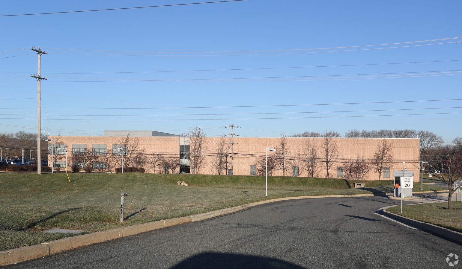
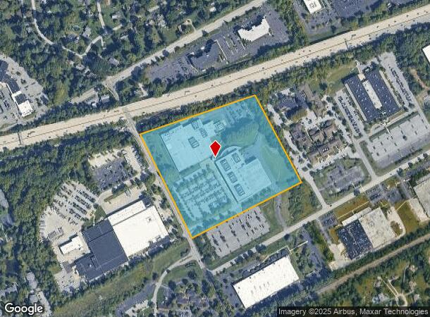
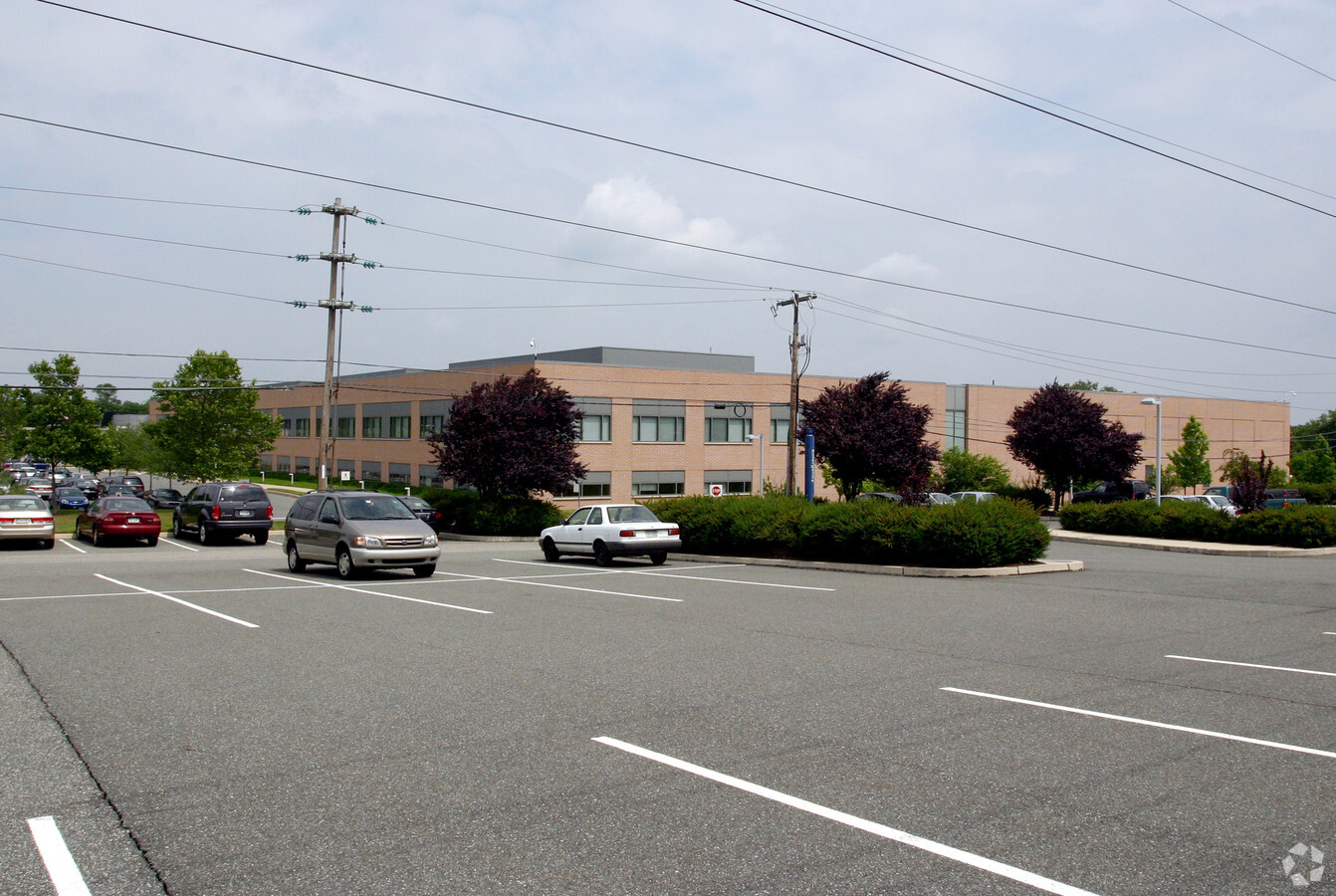
Property Record
1041 W Valley Rd, Wayne, PA 19087
NEARBY LISTINGS FOR SALE OR LEASE
Property Detail
1041 W Valley Rd
43-06J-0015.0100
22 AC & COMM LOT 1
Officebuilding
Chester
X
Pennsylvania
42029C0115G
1
2024
22 AC
2024
King of Prussia/Wayne
300108
Philadelphia
322,736 SF
Philadelphia-Camden-Wilmington, PA-NJ-DE-MD
DEMOGRAPHICS near 1041 W Valley Rd
1 Mile
3 Mile
5 Mile
2024 Total Population
4,245
60,433
140,838
2029 Population
4,420
62,479
144,469
Pop Growth 2024-2029
+ 4.12%
+ 3.39%
+ 2.58%
Average Age
43
40
41
2024 Total Households
1,801
24,465
54,719
HH Growth 2024-2029
+ 3.94%
+ 3.70%
+ 2.80%
Median Household Inc
$152,311
$122,907
$116,714
Avg Household Size
2.30
2.30
2.40
2024 Avg HH Vehicles
2.00
2.00
2.00
Median Home Value
$701,661
$625,472
$514,922
Median Year Built
1962
1975
1971
Nearby Places
- Restaurants
- Banks
- Shops
- Fitness
- Groceries
PUBLIC TRANSPORTATION
COMMUTER RAIL
Strafford (R5 - Southeastern Pennsylvania Transportation Authority Regional Rail (SEPTA Regional Rail))
DRIVE
WALK
Distance
Strafford (R5 - Southeastern Pennsylvania Transportation Authority Regional Rail (SEPTA Regional Rail))
6 min
2.1 mi
Devon (R5 - Southeastern Pennsylvania Transportation Authority Regional Rail (SEPTA Regional Rail))
DRIVE
WALK
Distance
Devon (R5 - Southeastern Pennsylvania Transportation Authority Regional Rail (SEPTA Regional Rail))
8 min
3.0 mi
AIRPORT
Philadelphia International
DRIVE
WALK
Distance
Philadelphia International
42 min
23.9 mi
Freight Ports
South Jersey Port
DRIVE
WALK
Distance
South Jersey Port
37 min
24.0 mi
Nearby Properties
Address
Land Use
TOTAL SIZE
Lot Size
Zoning
Address
Land Use
TOTAL SIZE
Lot Size
Zoning
2,373,472 SF
96.77 AC
SC
Address
Land Use
TOTAL SIZE
Lot Size
Zoning
536,904 SF
8.84 AC
AG
Address
Land Use
TOTAL SIZE
Lot Size
Zoning
679,715 SF
58.23 AC
R2
Address
Land Use
TOTAL SIZE
Lot Size
Zoning
1,724,092 SF
24 AC
SC
Address
Land Use
TOTAL SIZE
Lot Size
Zoning
45,871 SF
112 AC
Address
Land Use
TOTAL SIZE
Lot Size
Zoning
649,339 SF
3.69 AC
AG
Address
Land Use
TOTAL SIZE
Lot Size
Zoning
325,016 SF
1.62 AC
P
Address
Land Use
TOTAL SIZE
Lot Size
Zoning
546,664 SF
2.83 AC
AG
Address
Land Use
TOTAL SIZE
Lot Size
Zoning
388,042 SF
24.45 AC
SM
Address
Land Use
TOTAL SIZE
Lot Size
Zoning
583,559 SF
AG
Address
Land Use
TOTAL SIZE
Lot Size
Zoning
547,377 SF
3.28 AC
AG
Address
Land Use
TOTAL SIZE
Lot Size
Zoning
617,174 SF
25.32 AC
HR
Address
Land Use
TOTAL SIZE
Lot Size
Zoning
454,933 SF
17.85 AC
SM
Address
Land Use
TOTAL SIZE
Lot Size
Zoning
451,865 SF
19.90 AC
R2
Address
Land Use
TOTAL SIZE
Lot Size
Zoning
413,892 SF
21.94 AC
SM
Address
Land Use
TOTAL SIZE
Lot Size
Zoning
493,690 SF
4.75 AC
AG
Address
Land Use
TOTAL SIZE
Lot Size
Zoning
502,080 SF
11.36 AC
RA
Address
Land Use
TOTAL SIZE
Lot Size
Zoning
260,938 SF
9.81 AC
SM1
Address
Land Use
TOTAL SIZE
Lot Size
Zoning
311,353 SF
7.41 AC
SM1
Address
Land Use
TOTAL SIZE
Lot Size
Zoning
488,970 SF
24.68 AC
AR
Address
Land Use
TOTAL SIZE
Lot Size
Zoning
197,108 SF
2.08 AC
SC
Address
Land Use
TOTAL SIZE
Lot Size
Zoning
503,942 SF
11.26 AC
RA
Address
Land Use
TOTAL SIZE
Lot Size
Zoning
414,642 SF
3.70 AC
AG
Address
Land Use
TOTAL SIZE
Lot Size
Zoning
30,787 SF
30.50 AC
Address
Land Use
TOTAL SIZE
Lot Size
Zoning
381,927 SF
5.10 AC
SM
Address
Land Use
TOTAL SIZE
Lot Size
Zoning
114,121 SF
16.80 AC
LI
Address
Land Use
TOTAL SIZE
Lot Size
Zoning
29,364 SF
21.90 AC
Address
Land Use
TOTAL SIZE
Lot Size
Zoning
6,210 SF
17.16 AC
Address
Land Use
TOTAL SIZE
Lot Size
Zoning
290,066 SF
8.50 AC
SM
The World's #1 Commercial Real Estate Marketplace
Connect with us
© 2025 CoStar Group
The information above has been obtained from sources believed reliable. While we do not doubt its accuracy we have not verified it and make no guarantee, warranty or representation about it. It is your responsibility to independently confirm its accuracy and completeness. Any projections, opinions, assumptions, or estimates used are for example only and do not represent the current or future performance of the property. The value of this transaction to you depends on tax and other factors which should be evaluated by your tax, financial, and legal advisors. You and your advisors should conduct a careful, independent investigation of the property to determine to your satisfaction the suitability of the property for your needs.