Property Record
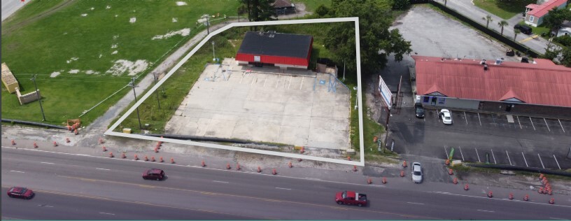
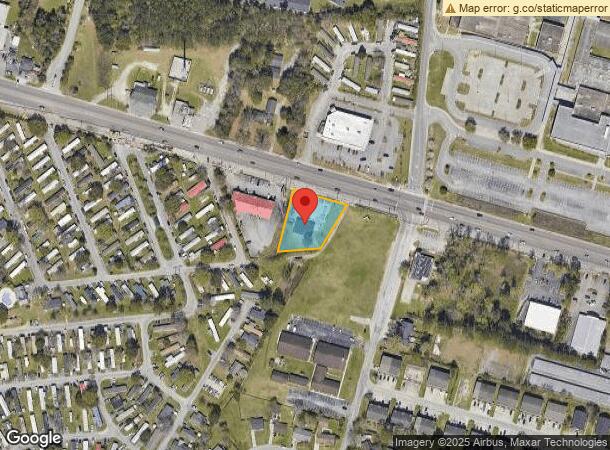
1044 Red Bank Rd, Goose Creek, SC 29445
This Property Is For Sale
NEARBY LISTINGS FOR SALE OR LEASE
Property Detail
1044 Red Bank Rd
252-06-00-003
Comm Redbank/52 & Redbank/N Rhett
Storebuilding
ASSESSMENT DISTRICT: 997CONVENIENCE STORES (7-11, ETC.)ACCT. 5602
X
Berkeley
45019C0285K
South Carolina
2024
0.65 AC
2023
Outlying Berkeley County
020810
Charleston/N Charleston
2,400 SF
Charleston-North Charleston, SC
DEMOGRAPHICS near 1044 Red Bank Rd
1 Mile
3 Mile
5 Mile
2024 Total Population
11,753
57,088
115,864
2029 Population
13,722
64,760
131,079
Pop Growth 2024-2029
+ 16.75%
+ 13.44%
+ 13.13%
Average Age
36
36
37
2024 Total Households
4,504
21,083
43,849
HH Growth 2024-2029
+ 16.81%
+ 13.23%
+ 12.95%
Median Household Inc
$56,770
$67,461
$67,532
Avg Household Size
2.60
2.50
2.50
2024 Avg HH Vehicles
2.00
2.00
2.00
Median Home Value
$169,749
$225,567
$232,097
Median Year Built
1989
1992
1991
Nearby Places
- Restaurants
- Banks
- Shops
- Fitness
- Groceries
PUBLIC TRANSPORTATION
COMMUTER RAIL
Charleston Amtrak Station (Palmetto - Amtrak, Silver Meteor - Amtrak)
DRIVE
WALK
Distance
Charleston Amtrak Station (Palmetto - Amtrak, Silver Meteor - Amtrak)
14 min
10.0 mi
AIRPORT
Charleston AFB/International
DRIVE
WALK
Distance
Charleston AFB/International
21 min
11.3 mi
Freight Ports
North Charleston Terminal
DRIVE
WALK
Distance
North Charleston Terminal
10 min
5.8 mi
Nearby Properties
Address
Land Use
TOTAL SIZE
Lot Size
Zoning
Address
Land Use
TOTAL SIZE
Lot Size
Zoning
10,172 SF
12.76 AC
Address
Land Use
TOTAL SIZE
Lot Size
Zoning
101,011 SF
6.58 AC
Address
Land Use
TOTAL SIZE
Lot Size
Zoning
14,725 SF
3.55 AC
Address
Land Use
TOTAL SIZE
Lot Size
Zoning
Address
Land Use
TOTAL SIZE
Lot Size
Zoning
58,444 SF
5.61 AC
Address
Land Use
TOTAL SIZE
Lot Size
Zoning
169,262 SF
14.87 AC
Address
Land Use
TOTAL SIZE
Lot Size
Zoning
293,825 SF
30.43 AC
Address
Land Use
TOTAL SIZE
Lot Size
Zoning
22,246 SF
5.25 AC
Address
Land Use
TOTAL SIZE
Lot Size
Zoning
13,012 SF
1.40 AC
Address
Land Use
TOTAL SIZE
Lot Size
Zoning
16,000 SF
2.61 AC
Address
Land Use
TOTAL SIZE
Lot Size
Zoning
5,400 SF
5.86 AC
Address
Land Use
TOTAL SIZE
Lot Size
Zoning
13,696 SF
25.08 AC
BERKELEY C
Address
Land Use
TOTAL SIZE
Lot Size
Zoning
9,967 SF
1.74 AC
Address
Land Use
TOTAL SIZE
Lot Size
Zoning
Address
Land Use
TOTAL SIZE
Lot Size
Zoning
313,920 SF
23.09 AC
HANAHAN -
Address
Land Use
TOTAL SIZE
Lot Size
Zoning
2,917 SF
11.76 AC
HANAHAN -
Address
Land Use
TOTAL SIZE
Lot Size
Zoning
247,000 SF
19.55 AC
HANAHAN -
Address
Land Use
TOTAL SIZE
Lot Size
Zoning
34,600 SF
1.88 AC
Address
Land Use
TOTAL SIZE
Lot Size
Zoning
315,489 SF
28 AC
BERKELEY C
Address
Land Use
TOTAL SIZE
Lot Size
Zoning
11,444 SF
16.50 AC
Address
Land Use
TOTAL SIZE
Lot Size
Zoning
302,400 SF
18.71 AC
HANAHAN -
Address
Land Use
TOTAL SIZE
Lot Size
Zoning
302,400 SF
23.70 AC
HANAHAN -
Address
Land Use
TOTAL SIZE
Lot Size
Zoning
3,719 SF
17.56 AC
Address
Land Use
TOTAL SIZE
Lot Size
Zoning
350,760 SF
25.65 AC
HANAHAN -
Address
Land Use
TOTAL SIZE
Lot Size
Zoning
12,718 SF
14.48 AC
Address
Land Use
TOTAL SIZE
Lot Size
Zoning
137,576 SF
5 AC
HANAHAN -
Address
Land Use
TOTAL SIZE
Lot Size
Zoning
25,350 SF
20.21 AC
Address
Land Use
TOTAL SIZE
Lot Size
Zoning
10,858 SF
13.30 AC
Address
Land Use
TOTAL SIZE
Lot Size
Zoning
6,032 SF
11.17 AC
GOOSE CREE
Address
Land Use
TOTAL SIZE
Lot Size
Zoning
286,710 SF
14.76 AC
BERKELEY C
The World's #1 Commercial Real Estate Marketplace
Connect with us
© 2025 CoStar Group
The information above has been obtained from sources believed reliable. While we do not doubt its accuracy we have not verified it and make no guarantee, warranty or representation about it. It is your responsibility to independently confirm its accuracy and completeness. Any projections, opinions, assumptions, or estimates used are for example only and do not represent the current or future performance of the property. The value of this transaction to you depends on tax and other factors which should be evaluated by your tax, financial, and legal advisors. You and your advisors should conduct a careful, independent investigation of the property to determine to your satisfaction the suitability of the property for your needs.