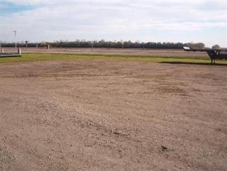
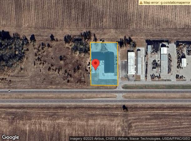
Property Record
10478 265Th St, Clear Lake, IA 50428
NEARBY LISTINGS FOR SALE OR LEASE
Property Detail
10478 265Th St
06-10-100-01-000
W 236.2' E 325.6' S 442' SE NW 10-96-21 EXC STATE OF IOWA BK 129 PG 263
Storebuilding
Cerro Gordo
X
Iowa
19033C0143D
2.09 AC
2024
Iowa Northeast Area
2024
Other Market Areas
950700
Mason City, IA
14,450 SF
DEMOGRAPHICS near 10478 265Th St
1 Mile
3 Mile
5 Mile
2024 Total Population
17
1,253
14,395
2029 Population
16
1,222
14,144
Pop Growth 2024-2029
(5.88%)
(2.47%)
(1.74%)
Average Age
42
45
45
2024 Total Households
8
583
6,677
HH Growth 2024-2029
(12.50%)
(2.57%)
(1.93%)
Median Household Inc
$67,500
$57,980
$60,127
Avg Household Size
2.00
2.10
2.10
2024 Avg HH Vehicles
2.00
2.00
2.00
Median Home Value
$166,666
$170,125
$177,484
Median Year Built
1969
1969
1968
Nearby Places
- Restaurants
- Banks
- Shops
- Fitness
- Groceries
Nearby Properties
Address
Land Use
TOTAL SIZE
Lot Size
Zoning
Address
Land Use
TOTAL SIZE
Lot Size
Zoning
179,674 SF
25.60 AC
Address
Land Use
TOTAL SIZE
Lot Size
Zoning
30,000 SF
70.31 AC
Address
Land Use
TOTAL SIZE
Lot Size
Zoning
214,003 SF
20.89 AC
Address
Land Use
TOTAL SIZE
Lot Size
Zoning
4,860 SF
22.86 AC
Address
Land Use
TOTAL SIZE
Lot Size
Zoning
173,295 SF
16.06 AC
Address
Land Use
TOTAL SIZE
Lot Size
Zoning
51,438 SF
Address
Land Use
TOTAL SIZE
Lot Size
Zoning
37,603 SF
3.99 AC
Address
Land Use
TOTAL SIZE
Lot Size
Zoning
26,400 SF
118.55 AC
Address
Land Use
TOTAL SIZE
Lot Size
Zoning
5,400 SF
31.68 AC
Address
Land Use
TOTAL SIZE
Lot Size
Zoning
126,525 SF
18.97 AC
Address
Land Use
TOTAL SIZE
Lot Size
Zoning
68,616 SF
5.38 AC
Address
Land Use
TOTAL SIZE
Lot Size
Zoning
44,396 SF
4.53 AC
Address
Land Use
TOTAL SIZE
Lot Size
Zoning
3,774 SF
40.97 AC
Address
Land Use
TOTAL SIZE
Lot Size
Zoning
113,067 SF
13.86 AC
Address
Land Use
TOTAL SIZE
Lot Size
Zoning
7,637 SF
19.04 AC
Address
Land Use
TOTAL SIZE
Lot Size
Zoning
1,600 SF
12.32 AC
Address
Land Use
TOTAL SIZE
Lot Size
Zoning
48,408 SF
2.22 AC
Address
Land Use
TOTAL SIZE
Lot Size
Zoning
21,084 SF
4.49 AC
Address
Land Use
TOTAL SIZE
Lot Size
Zoning
24,996 SF
Address
Land Use
TOTAL SIZE
Lot Size
Zoning
9,616 SF
5.20 AC
Address
Land Use
TOTAL SIZE
Lot Size
Zoning
28,474 SF
5.20 AC
Address
Land Use
TOTAL SIZE
Lot Size
Zoning
57,645 SF
22.31 AC
Address
Land Use
TOTAL SIZE
Lot Size
Zoning
5,576 SF
7.79 AC
Address
Land Use
TOTAL SIZE
Lot Size
Zoning
49,034 SF
3.16 AC
Address
Land Use
TOTAL SIZE
Lot Size
Zoning
13,362 SF
8.40 AC
Address
Land Use
TOTAL SIZE
Lot Size
Zoning
5,226 SF
9.69 AC
Address
Land Use
TOTAL SIZE
Lot Size
Zoning
9,152 SF
2.23 AC
Address
Land Use
TOTAL SIZE
Lot Size
Zoning
52,275 SF
6.12 AC
Address
Land Use
TOTAL SIZE
Lot Size
Zoning
3,600 SF
7.57 AC
Address
Land Use
TOTAL SIZE
Lot Size
Zoning
3,116 SF
29.66 AC
The World's #1 Commercial Real Estate Marketplace
Connect with us
© 2025 CoStar Group
The information above has been obtained from sources believed reliable. While we do not doubt its accuracy we have not verified it and make no guarantee, warranty or representation about it. It is your responsibility to independently confirm its accuracy and completeness. Any projections, opinions, assumptions, or estimates used are for example only and do not represent the current or future performance of the property. The value of this transaction to you depends on tax and other factors which should be evaluated by your tax, financial, and legal advisors. You and your advisors should conduct a careful, independent investigation of the property to determine to your satisfaction the suitability of the property for your needs.