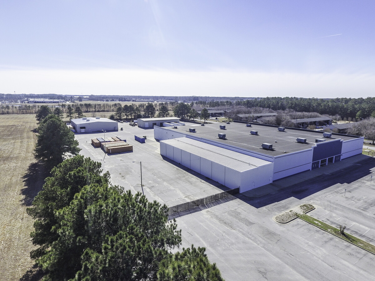
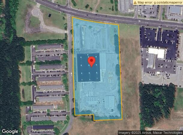
Property Record
1055 Sw Greenville Blvd Sw, Greenville, NC 27834
NEARBY LISTINGS FOR SALE OR LEASE
Property Detail
1055 Sw Greenville Blvd Sw
045784
Tucker Farms Dev Sec I
Warehouse
TUCKER FARMS DEVELOPMENT
X
Pitt
3720467600K
North Carolina
2024
11.62 AC
2024
Southwest Greenville
000603
Other Market Areas
94,140 SF
Greenville, NC
DEMOGRAPHICS near 1055 Sw Greenville Blvd Sw
1 Mile
3 Mile
5 Mile
2024 Total Population
8,038
57,844
109,644
2029 Population
8,286
60,621
115,242
Pop Growth 2024-2029
+ 3.09%
+ 4.80%
+ 5.11%
Average Age
35
36
36
2024 Total Households
3,359
25,354
46,916
HH Growth 2024-2029
+ 3.39%
+ 5.09%
+ 5.59%
Median Household Inc
$32,807
$45,897
$44,689
Avg Household Size
2.30
2.20
2.20
2024 Avg HH Vehicles
1.00
2.00
2.00
Median Home Value
$176,028
$180,118
$182,846
Median Year Built
1992
1993
1991
Nearby Places
- Restaurants
- Banks
- Shops
- Fitness
- Groceries
PUBLIC TRANSPORTATION
AIRPORT
Pitt-Greenville
DRIVE
WALK
Distance
Pitt-Greenville
17 min
9.2 mi
Freight Ports
Port of Morehead City
DRIVE
WALK
Distance
Port of Morehead City
128 min
85.3 mi
SALE & LEASE HISTORY
LISTING DATE
SALE/LEASE

Mar 22, 2024
For Sale
Nearby Properties
Address
Land Use
TOTAL SIZE
Lot Size
Zoning
Address
Land Use
TOTAL SIZE
Lot Size
Zoning
466,175 SF
14.08 AC
MS
Address
Land Use
TOTAL SIZE
Lot Size
Zoning
302,575 SF
29.53 AC
MI
Address
Land Use
TOTAL SIZE
Lot Size
Zoning
678,883 SF
41.95 AC
MI
Address
Land Use
TOTAL SIZE
Lot Size
Zoning
186,634 SF
14.40 AC
MI
Address
Land Use
TOTAL SIZE
Lot Size
Zoning
184,433 SF
71.40 AC
MI
Address
Land Use
TOTAL SIZE
Lot Size
Zoning
512,349 SF
39.27 AC
CG
Address
Land Use
TOTAL SIZE
Lot Size
Zoning
33,163 SF
20.14 AC
OR
Address
Land Use
TOTAL SIZE
Lot Size
Zoning
130,632 SF
5.06 AC
MI
Address
Land Use
TOTAL SIZE
Lot Size
Zoning
142,831 SF
13.61 AC
MO
Address
Land Use
TOTAL SIZE
Lot Size
Zoning
25,290 SF
18.26 AC
OR
Address
Land Use
TOTAL SIZE
Lot Size
Zoning
18,932 SF
11.51 AC
MR
Address
Land Use
TOTAL SIZE
Lot Size
Zoning
251,265 SF
30.17 AC
0&I
Address
Land Use
TOTAL SIZE
Lot Size
Zoning
162,126 SF
30 AC
OI
Address
Land Use
TOTAL SIZE
Lot Size
Zoning
23,772 SF
8.75 AC
MR
Address
Land Use
TOTAL SIZE
Lot Size
Zoning
20,292 SF
12.40 AC
OR
Address
Land Use
TOTAL SIZE
Lot Size
Zoning
6,148 SF
10.75 AC
R6
Address
Land Use
TOTAL SIZE
Lot Size
Zoning
152,334 SF
15.92 AC
CG
Address
Land Use
TOTAL SIZE
Lot Size
Zoning
94,176 SF
23.12 AC
R6
Address
Land Use
TOTAL SIZE
Lot Size
Zoning
19,183 SF
5.85 AC
OR
Address
Land Use
TOTAL SIZE
Lot Size
Zoning
77,707 SF
6.37 AC
MS
Address
Land Use
TOTAL SIZE
Lot Size
Zoning
111,735 SF
18.40 AC
MI
Address
Land Use
TOTAL SIZE
Lot Size
Zoning
15,896 SF
9.90 AC
MR
Address
Land Use
TOTAL SIZE
Lot Size
Zoning
20,742 SF
12.83 AC
R6
Address
Land Use
TOTAL SIZE
Lot Size
Zoning
64,547 SF
28.84 AC
MO
Address
Land Use
TOTAL SIZE
Lot Size
Zoning
121,384 SF
17.80 AC
CG
Address
Land Use
TOTAL SIZE
Lot Size
Zoning
63,504 SF
15.20 AC
CG
Address
Land Use
TOTAL SIZE
Lot Size
Zoning
18,662 SF
29.43 AC
R6
Address
Land Use
TOTAL SIZE
Lot Size
Zoning
118,668 SF
9.49 AC
CH
Address
Land Use
TOTAL SIZE
Lot Size
Zoning
26,958 SF
7.67 AC
MR
Address
Land Use
TOTAL SIZE
Lot Size
Zoning
84,649 SF
44.78 AC
AR
The World's #1 Commercial Real Estate Marketplace
Connect with us
© 2025 CoStar Group
The information above has been obtained from sources believed reliable. While we do not doubt its accuracy we have not verified it and make no guarantee, warranty or representation about it. It is your responsibility to independently confirm its accuracy and completeness. Any projections, opinions, assumptions, or estimates used are for example only and do not represent the current or future performance of the property. The value of this transaction to you depends on tax and other factors which should be evaluated by your tax, financial, and legal advisors. You and your advisors should conduct a careful, independent investigation of the property to determine to your satisfaction the suitability of the property for your needs.