Property Record
1060 Hempstead Tpke, Franklin Square, NY 11010

Property Detail
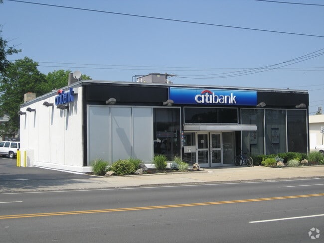
1060 Hempstead Tpke
Nassau County-Suffolk County, NY
TOWN #1 SCH DIST 017
2089-33-384-00-0424-0
Nassau
Financialbuilding
New York
B and X Area of moderate flood hazard, usually the area between the limits of the 100-year and 500-year floods.
424
2025
0.26 AC
2025
Central Nassau
405500
Long Island (New York)
8,014 SF
NEARBY LISTINGS FOR SALE OR LEASE
DEMOGRAPHICS near 1060 Hempstead Tpke
1 mile
3 mile
5 mile
2025 Total Population
33,226
253,188
764,433
2030 Population
32,436
250,160
754,519
Pop Growth 2025-2030
(2.38%)
(1.20%)
(1.30%)
Average Age
42
42
42
2025 Total Households
10,429
79,202
242,479
HH Growth 2025-2030
(2.42%)
(1.31%)
(1.52%)
Median Household Inc
$130,698
$132,649
$121,434
Avg Household Size
3.10
3.10
3.00
2025 Avg HH Vehicles
2.00
2.00
2.00
Median Home Value
$728,375
$730,863
$714,162
Median Year Built
1951
1950
1951
Nearby Places
Map Layers
Map Styles
 Street
 Aerial
Layers
 Traffic
 Biking
Places
Listings with unknown addresses are not visible on the map
- Restaurants
- Banks
- Shops
- Fitness
- Groceries
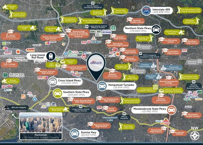
PUBLIC TRANSPORTATION
COMMUTER RAIL
Stewart Manor Station (Hempstead Branch - Long Island Rail Road)
Drive
Walk
Distance
Stewart Manor Station (Hempstead Branch - Long Island Rail Road)
3 min
1.4 mi
New Hyde Park Station (Port Jefferson Branch - Long Island Rail Road)
Drive
Walk
Distance
New Hyde Park Station (Port Jefferson Branch - Long Island Rail Road)
5 min
2.1 mi
AIRPORT
John F Kennedy International
Drive
Walk
Distance
John F Kennedy International
19 min
10.7 mi
LaGuardia
Drive
Walk
Distance
LaGuardia
25 min
14.2 mi
Westchester County
Drive
Walk
Distance
Westchester County
54 min
35.7 mi
Freight Ports
NY - Red Hook Container Terminal
Drive
Walk
Distance
NY - Red Hook Container Terminal
36 min
22.3 mi
SALE & LEASE HISTORY
LISTING DATE
SALE/LEASE

Jun 10, 2022
For Sale
Nearby Properties
Address
Land Use
TOTAL SIZE
Lot Size
Zoning
Address
Land Use
TOTAL SIZE
Lot Size
Zoning
171,000 SF
2.76 AC
R2A
Address
Land Use
TOTAL SIZE
Lot Size
Zoning
99,814 SF
1.31 AC
R3-2
Address
Land Use
TOTAL SIZE
Lot Size
Zoning
170,000 SF
4.02 AC
R3-2
Address
Land Use
TOTAL SIZE
Lot Size
Zoning
70,734 SF
2.94 AC
R2A
Address
Land Use
TOTAL SIZE
Lot Size
Zoning
32,000 SF
8.70 AC
M1-1
Address
Land Use
TOTAL SIZE
Lot Size
Zoning
53,700 SF
2.92 AC
R4-1
Address
Land Use
TOTAL SIZE
Lot Size
Zoning
59,426 SF
0.65 AC
C8-1
Address
Land Use
TOTAL SIZE
Lot Size
Zoning
108,051 SF
0.96 AC
C8-1
Address
Land Use
TOTAL SIZE
Lot Size
Zoning
57,000 SF
2.16 AC
R2A
Address
Land Use
TOTAL SIZE
Lot Size
Zoning
36,500 SF
2 AC
R2A
Address
Land Use
TOTAL SIZE
Lot Size
Zoning
36,667 SF
2.65 AC
C8-1
Address
Land Use
TOTAL SIZE
Lot Size
Zoning
46,962 SF
0.76 AC
R3-2
Address
Land Use
TOTAL SIZE
Lot Size
Zoning
58,868 SF
0.76 AC
R3-2
Address
Land Use
TOTAL SIZE
Lot Size
Zoning
72,000 SF
2.98 AC
M1-1
Address
Land Use
TOTAL SIZE
Lot Size
Zoning
1,867,677 SF
385.47 AC
Address
Land Use
TOTAL SIZE
Lot Size
Zoning
8,998 SF
0.73 AC
R2A
Address
Land Use
TOTAL SIZE
Lot Size
Zoning
1,511 SF
3.21 AC
PARK
Address
Land Use
TOTAL SIZE
Lot Size
Zoning
26,744 SF
1.39 AC
R3-2
Address
Land Use
TOTAL SIZE
Lot Size
Zoning
47,062 SF
1.93 AC
R3-2
Address
Land Use
TOTAL SIZE
Lot Size
Zoning
202.54 AC
Address
Land Use
TOTAL SIZE
Lot Size
Zoning
76,800 SF
1.12 AC
R3-2
Address
Land Use
TOTAL SIZE
Lot Size
Zoning
23,153 SF
1.72 AC
C8-1
Address
Land Use
TOTAL SIZE
Lot Size
Zoning
1,197,283 SF
64.50 AC
Address
Land Use
TOTAL SIZE
Lot Size
Zoning
13,075 SF
0.22 AC
C8-1
Address
Land Use
TOTAL SIZE
Lot Size
Zoning
14,570 SF
0.77 AC
R3-2
Address
Land Use
TOTAL SIZE
Lot Size
Zoning
574,353 SF
65 AC
Address
Land Use
TOTAL SIZE
Lot Size
Zoning
6,650 SF
1.10 AC
R2
Address
Land Use
TOTAL SIZE
Lot Size
Zoning
12,050 SF
0.59 AC
R2A
Address
Land Use
TOTAL SIZE
Lot Size
Zoning
23,700 SF
0.48 AC
R3-2
Address
Land Use
TOTAL SIZE
Lot Size
Zoning
29,000 SF
0.69 AC
M1-1
The World's #1 Commercial Real Estate Marketplace
Connect with us
© 2026 CoStar Group
The information above has been obtained from sources believed reliable. While we do not doubt its accuracy we have not verified it and make no guarantee, warranty or representation about it. It is your responsibility to independently confirm its accuracy and completeness. Any projections, opinions, assumptions, or estimates used are for example only and do not represent the current or future performance of the property. The value of this transaction to you depends on tax and other factors which should be evaluated by your tax, financial, and legal advisors. You and your advisors should conduct a careful, independent investigation of the property to determine to your satisfaction the suitability of the property for your needs.