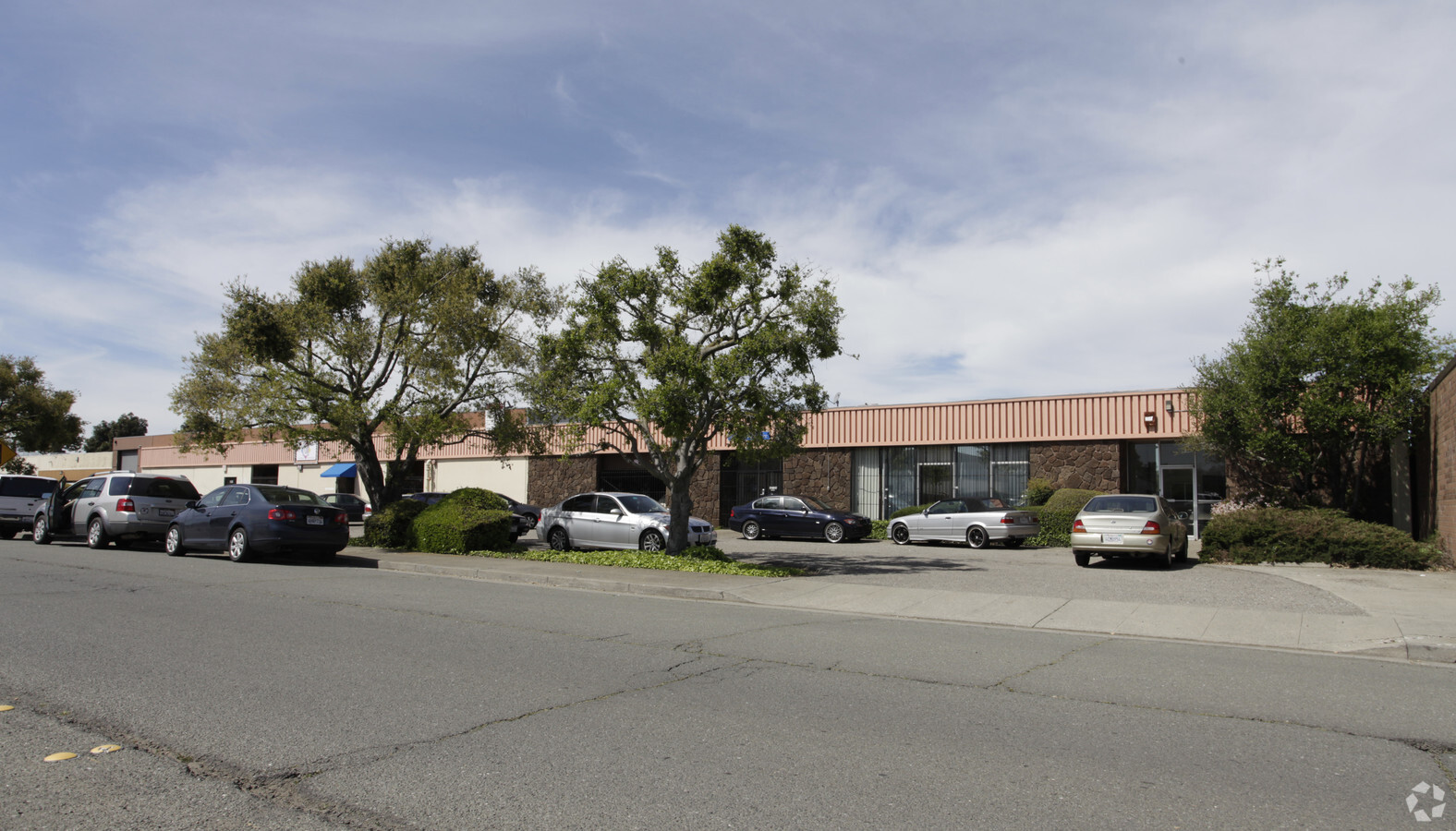
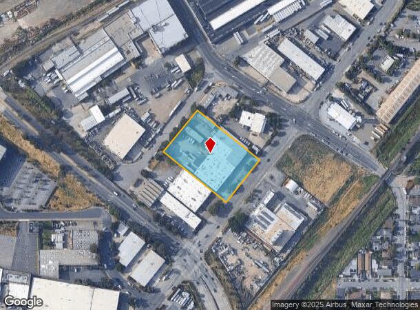
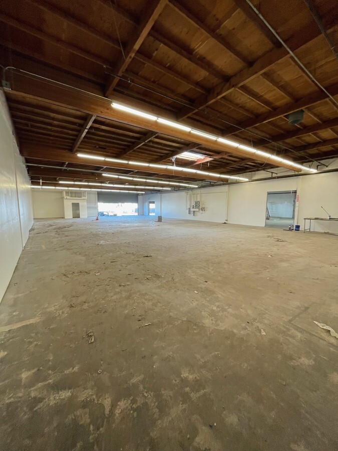
Property Record
1063 Hensley St, Richmond, CA 94801
Current Lease Availabilities
NEARBY LISTINGS FOR SALE OR LEASE
Property Detail
1063 Hensley St
Oakland-Hayward-Berkeley, CA
Subdivision 2986
561-318-016-4
PORTION LOTS2&12
Industrialpark
Contra Costa
X
California
06013C0228G
4
2023
2 AC
2024
Richmond/San Pablo
378000
East Bay/Oakland
35,099 SF
DEMOGRAPHICS near 1063 Hensley St
1 Mile
3 Mile
5 Mile
2024 Total Population
28,080
131,033
205,210
2029 Population
27,827
129,843
203,280
Pop Growth 2024-2029
(0.90%)
(0.91%)
(0.94%)
Average Age
35
38
39
2024 Total Households
7,370
41,281
68,735
HH Growth 2024-2029
(0.91%)
(0.94%)
(0.99%)
Median Household Inc
$66,388
$76,154
$85,353
Avg Household Size
3.60
3.00
2.90
2024 Avg HH Vehicles
2.00
2.00
2.00
Median Home Value
$474,513
$649,797
$717,314
Median Year Built
1959
1961
1962
Nearby Places
- Restaurants
- Banks
- Shops
- Fitness
- Groceries
PUBLIC TRANSPORTATION
COMMUTER RAIL
Berkeley (Capitol Corridor - Amtrak)
DRIVE
WALK
Distance
Berkeley (Capitol Corridor - Amtrak)
13 min
9.3 mi
Larkspur Smart (Main Line - Sonoma Marin Area Rail Transit)
DRIVE
WALK
Distance
Larkspur Smart (Main Line - Sonoma Marin Area Rail Transit)
17 min
9.6 mi
AIRPORT
Metro Oakland International
DRIVE
WALK
Distance
Metro Oakland International
33 min
23.7 mi
San Francisco International
DRIVE
WALK
Distance
San Francisco International
45 min
31.3 mi
Freight Ports
Port of Richmond
DRIVE
WALK
Distance
Port of Richmond
9 min
4.4 mi
Nearby Properties
Address
Land Use
TOTAL SIZE
Lot Size
Zoning
Address
Land Use
TOTAL SIZE
Lot Size
Zoning
269.14 AC
Address
Land Use
TOTAL SIZE
Lot Size
Zoning
244.30 AC
Address
Land Use
TOTAL SIZE
Lot Size
Zoning
55.76 AC
Address
Land Use
TOTAL SIZE
Lot Size
Zoning
38.33 AC
Address
Land Use
TOTAL SIZE
Lot Size
Zoning
820,000 SF
6.36 AC
Address
Land Use
TOTAL SIZE
Lot Size
Zoning
68,400 SF
5.13 AC
CM
Address
Land Use
TOTAL SIZE
Lot Size
Zoning
76.15 AC
Address
Land Use
TOTAL SIZE
Lot Size
Zoning
481,487 SF
27.88 AC
P-1
Address
Land Use
TOTAL SIZE
Lot Size
Zoning
205,900 SF
20.70 AC
P1
Address
Land Use
TOTAL SIZE
Lot Size
Zoning
476,200 SF
22.92 AC
Address
Land Use
TOTAL SIZE
Lot Size
Zoning
581,157 SF
10.52 AC
Address
Land Use
TOTAL SIZE
Lot Size
Zoning
195,281 SF
0.96 AC
Address
Land Use
TOTAL SIZE
Lot Size
Zoning
139,846 SF
0.76 AC
Address
Land Use
TOTAL SIZE
Lot Size
Zoning
3,950 SF
11.47 AC
Address
Land Use
TOTAL SIZE
Lot Size
Zoning
19,308 SF
40.39 AC
Address
Land Use
TOTAL SIZE
Lot Size
Zoning
35.94 AC
Address
Land Use
TOTAL SIZE
Lot Size
Zoning
4,550 SF
24.81 AC
Address
Land Use
TOTAL SIZE
Lot Size
Zoning
105,704 SF
10.85 AC
M3
Address
Land Use
TOTAL SIZE
Lot Size
Zoning
124,257 SF
2.72 AC
Address
Land Use
TOTAL SIZE
Lot Size
Zoning
16,800 SF
11.62 AC
Address
Land Use
TOTAL SIZE
Lot Size
Zoning
113,346 SF
10.11 AC
Address
Land Use
TOTAL SIZE
Lot Size
Zoning
202,811 SF
10.98 AC
Address
Land Use
TOTAL SIZE
Lot Size
Zoning
135,904 SF
7.12 AC
Address
Land Use
TOTAL SIZE
Lot Size
Zoning
191,800 SF
1.08 AC
Address
Land Use
TOTAL SIZE
Lot Size
Zoning
245,894 SF
12.67 AC
M2
Address
Land Use
TOTAL SIZE
Lot Size
Zoning
182,408 SF
10.55 AC
Address
Land Use
TOTAL SIZE
Lot Size
Zoning
34.95 AC
M3
Address
Land Use
TOTAL SIZE
Lot Size
Zoning
96,440 SF
4.73 AC
Address
Land Use
TOTAL SIZE
Lot Size
Zoning
118,658 SF
8.57 AC
Address
Land Use
TOTAL SIZE
Lot Size
Zoning
404,098 SF
24.03 AC
MSL1RD
The World's #1 Commercial Real Estate Marketplace
Connect with us
© 2025 CoStar Group
The information above has been obtained from sources believed reliable. While we do not doubt its accuracy we have not verified it and make no guarantee, warranty or representation about it. It is your responsibility to independently confirm its accuracy and completeness. Any projections, opinions, assumptions, or estimates used are for example only and do not represent the current or future performance of the property. The value of this transaction to you depends on tax and other factors which should be evaluated by your tax, financial, and legal advisors. You and your advisors should conduct a careful, independent investigation of the property to determine to your satisfaction the suitability of the property for your needs.