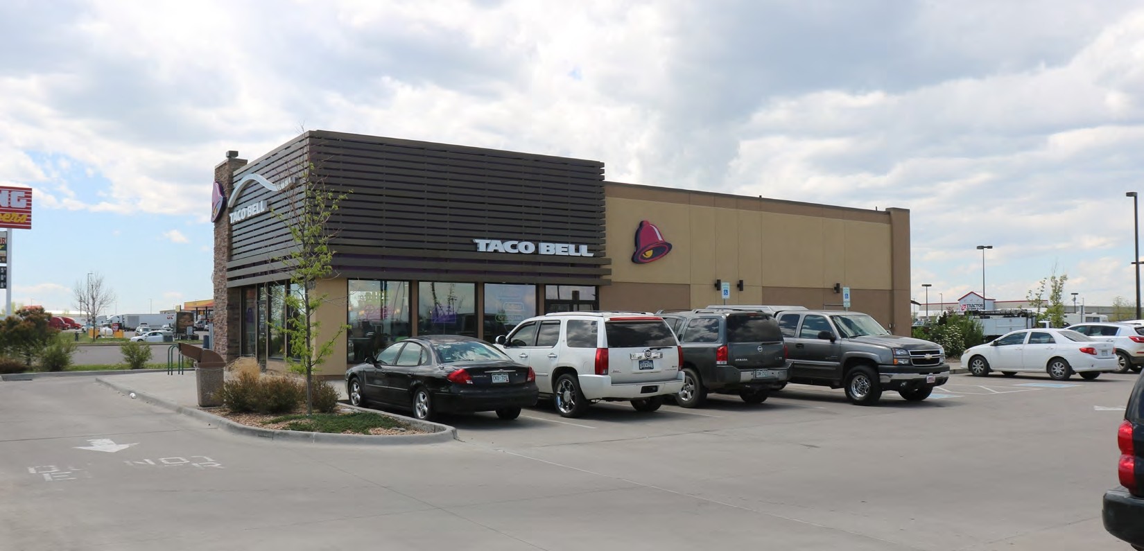
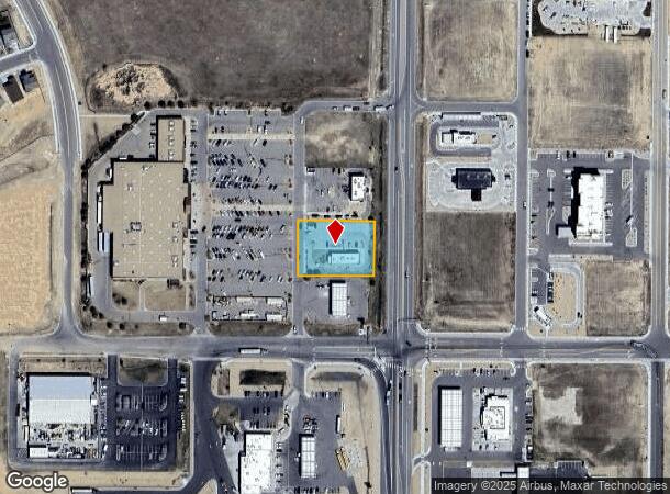
Property Record
1065 S 1St St, Bennett, CO 80102

NEARBY LISTINGS FOR SALE OR LEASE
Property Detail
1065 S 1St St
Denver-Aurora-Lakewood, CO
Muegge Farms
1815-33-4-01-014
MUEGGE FARMS SUBD FLG NO 1 AMND NO 2 BLK 1 LOT 3
Miscellaneous
Adams
X
Colorado
08005C0260K
3
2023
0.72 AC
2024
Northeast
008401
Denver
2,516 SF
DEMOGRAPHICS near 1065 S 1St St
1 Mile
3 Mile
5 Mile
2024 Total Population
999
3,774
5,363
2029 Population
1,075
4,016
5,602
Pop Growth 2024-2029
+ 7.61%
+ 6.41%
+ 4.46%
Average Age
36
37
38
2024 Total Households
338
1,279
1,823
HH Growth 2024-2029
+ 7.40%
+ 6.41%
+ 4.44%
Median Household Inc
$71,977
$74,049
$88,535
Avg Household Size
2.90
2.90
2.90
2024 Avg HH Vehicles
2.00
3.00
3.00
Median Home Value
$344,000
$365,014
$439,054
Median Year Built
1987
1988
1992
Nearby Places
- Restaurants
- Banks
- Shops
- Fitness
- Groceries
PUBLIC TRANSPORTATION
AIRPORT
Denver International
DRIVE
WALK
Distance
Denver International
32 min
28.0 mi
Freight Ports
Tulsa Port Of Catoosa
DRIVE
WALK
Distance
Tulsa Port Of Catoosa
693 min
677.9 mi
SALE & LEASE HISTORY
LISTING DATE
SALE/LEASE

Jun 05, 2019
For Sale
Nearby Properties
Address
Land Use
TOTAL SIZE
Lot Size
Zoning
Address
Land Use
TOTAL SIZE
Lot Size
Zoning
Address
Land Use
TOTAL SIZE
Lot Size
Zoning
47,641 SF
25.55 AC
Address
Land Use
TOTAL SIZE
Lot Size
Zoning
28,500 SF
4.99 AC
Address
Land Use
TOTAL SIZE
Lot Size
Zoning
66,260 SF
6.45 AC
Address
Land Use
TOTAL SIZE
Lot Size
Zoning
102,550 SF
2.13 AC
Address
Land Use
TOTAL SIZE
Lot Size
Zoning
7,140 SF
2.32 AC
Address
Land Use
TOTAL SIZE
Lot Size
Zoning
15,822 SF
7.02 AC
Address
Land Use
TOTAL SIZE
Lot Size
Zoning
45,147 SF
1.50 AC
Address
Land Use
TOTAL SIZE
Lot Size
Zoning
75.96 AC
Address
Land Use
TOTAL SIZE
Lot Size
Zoning
336 SF
0.25 AC
Address
Land Use
TOTAL SIZE
Lot Size
Zoning
23,486 SF
3.72 AC
Address
Land Use
TOTAL SIZE
Lot Size
Zoning
40,151 SF
7.09 AC
A3
Address
Land Use
TOTAL SIZE
Lot Size
Zoning
19,708 SF
13.20 AC
Address
Land Use
TOTAL SIZE
Lot Size
Zoning
16,515 SF
1.21 AC
A1
Address
Land Use
TOTAL SIZE
Lot Size
Zoning
6,336 SF
0.44 AC
Address
Land Use
TOTAL SIZE
Lot Size
Zoning
6,000 SF
0.86 AC
Address
Land Use
TOTAL SIZE
Lot Size
Zoning
12,320 SF
1.23 AC
Address
Land Use
TOTAL SIZE
Lot Size
Zoning
5,856 SF
5.28 AC
Address
Land Use
TOTAL SIZE
Lot Size
Zoning
9,170 SF
0.99 AC
Address
Land Use
TOTAL SIZE
Lot Size
Zoning
9,567 SF
1.35 AC
Address
Land Use
TOTAL SIZE
Lot Size
Zoning
6,906 SF
0.81 AC
Address
Land Use
TOTAL SIZE
Lot Size
Zoning
8,400 SF
1.56 AC
Address
Land Use
TOTAL SIZE
Lot Size
Zoning
6,400 SF
0.77 AC
Address
Land Use
TOTAL SIZE
Lot Size
Zoning
4,484 SF
0.49 AC
Address
Land Use
TOTAL SIZE
Lot Size
Zoning
6,116 SF
0.74 AC
Address
Land Use
TOTAL SIZE
Lot Size
Zoning
10,664 SF
0.76 AC
Address
Land Use
TOTAL SIZE
Lot Size
Zoning
7,296 SF
1.07 AC
Address
Land Use
TOTAL SIZE
Lot Size
Zoning
11,000 SF
5.01 AC
Address
Land Use
TOTAL SIZE
Lot Size
Zoning
131,551 SF
3.02 AC
Address
Land Use
TOTAL SIZE
Lot Size
Zoning
12,784 SF
2.10 AC
The World's #1 Commercial Real Estate Marketplace
Connect with us
© 2025 CoStar Group
The information above has been obtained from sources believed reliable. While we do not doubt its accuracy we have not verified it and make no guarantee, warranty or representation about it. It is your responsibility to independently confirm its accuracy and completeness. Any projections, opinions, assumptions, or estimates used are for example only and do not represent the current or future performance of the property. The value of this transaction to you depends on tax and other factors which should be evaluated by your tax, financial, and legal advisors. You and your advisors should conduct a careful, independent investigation of the property to determine to your satisfaction the suitability of the property for your needs.