Property Record
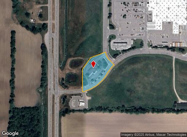
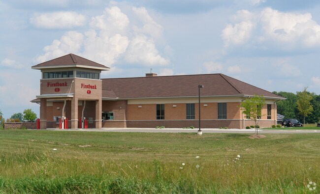
1065 Superior Dr, Saint Johns, MI 48879

NEARBY LISTINGS FOR SALE OR LEASE
Property Detail
1065 Superior Dr
030-022-300-012-00
Bingham Commerce Park
Financialbuilding
OUTLOT A1
X
Clinton
26037C0181D
Michigan
0
1.50 AC
2025
Outlying Clinton County
010901
West Michigan
3,184 SF
Lansing-East Lansing, MI
DEMOGRAPHICS near 1065 Superior Dr
1 Mile
3 Mile
5 Mile
2024 Total Population
1,378
10,611
12,721
2029 Population
1,402
10,836
12,970
Pop Growth 2024-2029
+ 1.74%
+ 2.12%
+ 1.96%
Average Age
43
42
42
2024 Total Households
568
4,389
5,162
HH Growth 2024-2029
+ 1.76%
+ 2.10%
+ 1.96%
Median Household Inc
$71,911
$71,171
$73,803
Avg Household Size
2.30
2.30
2.40
2024 Avg HH Vehicles
2.00
2.00
2.00
Median Home Value
$255,297
$183,463
$194,591
Median Year Built
1987
1970
1971
Nearby Places
Map Layers
Map Styles
 Street
 Aerial
- Restaurants
- Banks
- Shops
- Fitness
- Groceries
PUBLIC TRANSPORTATION
AIRPORT
Capital Region International
DRIVE
WALK
Distance
Capital Region International
28 min
18.5 mi
Freight Ports
Port of Toledo
DRIVE
WALK
Distance
Port of Toledo
164 min
131.3 mi
Nearby Properties
Address
Land Use
TOTAL SIZE
Lot Size
Zoning
Address
Land Use
TOTAL SIZE
Lot Size
Zoning
375,000 SF
Address
Land Use
TOTAL SIZE
Lot Size
Zoning
106,182 SF
65 AC
Address
Land Use
TOTAL SIZE
Lot Size
Zoning
46,540 SF
13.78 AC
RO
Address
Land Use
TOTAL SIZE
Lot Size
Zoning
137,552 SF
16.85 AC
I-2
Address
Land Use
TOTAL SIZE
Lot Size
Zoning
163,881 SF
14.07 AC
I-1
Address
Land Use
TOTAL SIZE
Lot Size
Zoning
84.91 AC
AGR
Address
Land Use
TOTAL SIZE
Lot Size
Zoning
190,942 SF
18.57 AC
C-2
Address
Land Use
TOTAL SIZE
Lot Size
Zoning
79,006 SF
31.12 AC
R3
Address
Land Use
TOTAL SIZE
Lot Size
Zoning
54,390 SF
22.62 AC
MC
Address
Land Use
TOTAL SIZE
Lot Size
Zoning
70,510 SF
9.33 AC
C-2
Address
Land Use
TOTAL SIZE
Lot Size
Zoning
22,740 SF
4.13 AC
GC
Address
Land Use
TOTAL SIZE
Lot Size
Zoning
36,505 SF
14.76 AC
GC
Address
Land Use
TOTAL SIZE
Lot Size
Zoning
69,347 SF
11.25 AC
GC
Address
Land Use
TOTAL SIZE
Lot Size
Zoning
6,208 SF
7.09 AC
R3
Address
Land Use
TOTAL SIZE
Lot Size
Zoning
34,423 SF
2.92 AC
O
Address
Land Use
TOTAL SIZE
Lot Size
Zoning
10,000 SF
6.50 AC
C-2
Address
Land Use
TOTAL SIZE
Lot Size
Zoning
17,760 SF
3.59 AC
R3
Address
Land Use
TOTAL SIZE
Lot Size
Zoning
89,500 SF
15.03 AC
C-2
Address
Land Use
TOTAL SIZE
Lot Size
Zoning
792 SF
14.48 AC
RMH
Address
Land Use
TOTAL SIZE
Lot Size
Zoning
17,760 SF
3.42 AC
R3
Address
Land Use
TOTAL SIZE
Lot Size
Zoning
54,154 SF
4.28 AC
I-1
Address
Land Use
TOTAL SIZE
Lot Size
Zoning
14,340 SF
15.81 AC
GC
Address
Land Use
TOTAL SIZE
Lot Size
Zoning
19,320 SF
3.40 AC
C-2
Address
Land Use
TOTAL SIZE
Lot Size
Zoning
45,744 SF
Address
Land Use
TOTAL SIZE
Lot Size
Zoning
9,600 SF
12.88 AC
I-1
Address
Land Use
TOTAL SIZE
Lot Size
Zoning
43,496 SF
7.31 AC
I-1
Address
Land Use
TOTAL SIZE
Lot Size
Zoning
5,086 SF
5.08 AC
C-2
Address
Land Use
TOTAL SIZE
Lot Size
Zoning
10,230 SF
2.64 AC
I-1
Address
Land Use
TOTAL SIZE
Lot Size
Zoning
48,916 SF
14.51 AC
C-2
Address
Land Use
TOTAL SIZE
Lot Size
Zoning
6,048 SF
5.81 AC
R3
The World's #1 Commercial Real Estate Marketplace
Connect with us
© 2026 CoStar Group
The information above has been obtained from sources believed reliable. While we do not doubt its accuracy we have not verified it and make no guarantee, warranty or representation about it. It is your responsibility to independently confirm its accuracy and completeness. Any projections, opinions, assumptions, or estimates used are for example only and do not represent the current or future performance of the property. The value of this transaction to you depends on tax and other factors which should be evaluated by your tax, financial, and legal advisors. You and your advisors should conduct a careful, independent investigation of the property to determine to your satisfaction the suitability of the property for your needs.