No Photo
Property Record
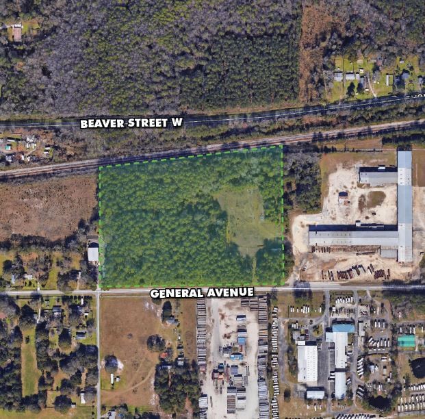
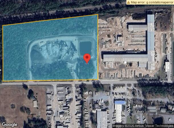
10655 General Ave, Jacksonville, FL 32220
NEARBY LISTINGS FOR SALE OR LEASE
Property Detail
10655 General Ave
006677-0100
White City S/D
Miningfacilityoilgasmineralpreciousmetals
5-71 19-2S-25E 17.47 WHITE CITY S/D PT OF BLK 20, BLK 21, PT CLD RWS RECD O/R 20193-1744
X
Duval
12031C0330H
Florida
2023
18.51 AC
2024
Northwest Jacksonville
011901
Jacksonville (Florida)
672 SF
Jacksonville, FL
DEMOGRAPHICS near 10655 General Ave
1 Mile
3 Mile
5 Mile
2024 Total Population
3,494
29,808
63,852
2029 Population
3,635
31,368
67,117
Pop Growth 2024-2029
+ 4.04%
+ 5.23%
+ 5.11%
Average Age
41
38
38
2024 Total Households
1,284
10,495
22,859
HH Growth 2024-2029
+ 4.13%
+ 5.27%
+ 5.15%
Median Household Inc
$75,357
$73,231
$66,192
Avg Household Size
2.70
2.80
2.70
2024 Avg HH Vehicles
2.00
2.00
2.00
Median Home Value
$250,623
$230,113
$206,818
Median Year Built
1995
1999
1994
Nearby Places
- Restaurants
- Banks
- Shops
- Fitness
- Groceries
PUBLIC TRANSPORTATION
AIRPORT
Jacksonville International
DRIVE
WALK
Distance
Jacksonville International
35 min
22.9 mi
Freight Ports
Jacksonville Port
DRIVE
WALK
Distance
Jacksonville Port
27 min
16.8 mi
SALE & LEASE HISTORY
LISTING DATE
SALE/LEASE

Sep 24, 2016
For Sale
Oct 10, 2016
For Sale
May 12, 2017
For Sale
Dec 01, 2016
For Sale
Aug 07, 2018
For Sale
Nearby Properties
Address
Land Use
TOTAL SIZE
Lot Size
Zoning
Address
Land Use
TOTAL SIZE
Lot Size
Zoning
185,662 SF
1,416.80 AC
PBF-3
Address
Land Use
TOTAL SIZE
Lot Size
Zoning
506,876 SF
39.32 AC
IBP
Address
Land Use
TOTAL SIZE
Lot Size
Zoning
421,500 SF
43.21 AC
PUD
Address
Land Use
TOTAL SIZE
Lot Size
Zoning
505,748 SF
94.71 AC
IL
Address
Land Use
TOTAL SIZE
Lot Size
Zoning
509,686 SF
43.32 AC
IL
Address
Land Use
TOTAL SIZE
Lot Size
Zoning
273,608 SF
23.14 AC
PUD
Address
Land Use
TOTAL SIZE
Lot Size
Zoning
139,435 SF
7.15 AC
CCG-2
Address
Land Use
TOTAL SIZE
Lot Size
Zoning
480,461 SF
43.54 AC
IL
Address
Land Use
TOTAL SIZE
Lot Size
Zoning
108,217 SF
178.52 AC
PBF-1
Address
Land Use
TOTAL SIZE
Lot Size
Zoning
269,178 SF
129.93 AC
PBF-2
Address
Land Use
TOTAL SIZE
Lot Size
Zoning
153,549 SF
15.96 AC
PBF-1
Address
Land Use
TOTAL SIZE
Lot Size
Zoning
878.69 AC
PUD
Address
Land Use
TOTAL SIZE
Lot Size
Zoning
160,778 SF
25.46 AC
IL
Address
Land Use
TOTAL SIZE
Lot Size
Zoning
30,789 SF
2.10 AC
PUD
Address
Land Use
TOTAL SIZE
Lot Size
Zoning
365.57 AC
PUD
Address
Land Use
TOTAL SIZE
Lot Size
Zoning
307.14 AC
PUD
Address
Land Use
TOTAL SIZE
Lot Size
Zoning
29,022 SF
3.17 AC
PUD
Address
Land Use
TOTAL SIZE
Lot Size
Zoning
171.06 AC
PUD
Address
Land Use
TOTAL SIZE
Lot Size
Zoning
33,424 SF
2.97 AC
PUD
Address
Land Use
TOTAL SIZE
Lot Size
Zoning
76,718 SF
8.89 AC
RR-ACRE
Address
Land Use
TOTAL SIZE
Lot Size
Zoning
53,405 SF
6.04 AC
PUD
Address
Land Use
TOTAL SIZE
Lot Size
Zoning
53,527 SF
10.89 AC
CCG-1
Address
Land Use
TOTAL SIZE
Lot Size
Zoning
73,426 SF
7.48 AC
PUD
Address
Land Use
TOTAL SIZE
Lot Size
Zoning
602.71 AC
PUD
Address
Land Use
TOTAL SIZE
Lot Size
Zoning
26,961 SF
1.36 AC
PUD
Address
Land Use
TOTAL SIZE
Lot Size
Zoning
36,354 SF
3.72 AC
CCG-1
Address
Land Use
TOTAL SIZE
Lot Size
Zoning
528.99 AC
PUD
Address
Land Use
TOTAL SIZE
Lot Size
Zoning
50,506 SF
9.44 AC
PBF-2
Address
Land Use
TOTAL SIZE
Lot Size
Zoning
404.50 AC
PUD
Address
Land Use
TOTAL SIZE
Lot Size
Zoning
153,671 SF
27.09 AC
IL
The World's #1 Commercial Real Estate Marketplace
Connect with us
© 2025 CoStar Group
The information above has been obtained from sources believed reliable. While we do not doubt its accuracy we have not verified it and make no guarantee, warranty or representation about it. It is your responsibility to independently confirm its accuracy and completeness. Any projections, opinions, assumptions, or estimates used are for example only and do not represent the current or future performance of the property. The value of this transaction to you depends on tax and other factors which should be evaluated by your tax, financial, and legal advisors. You and your advisors should conduct a careful, independent investigation of the property to determine to your satisfaction the suitability of the property for your needs.