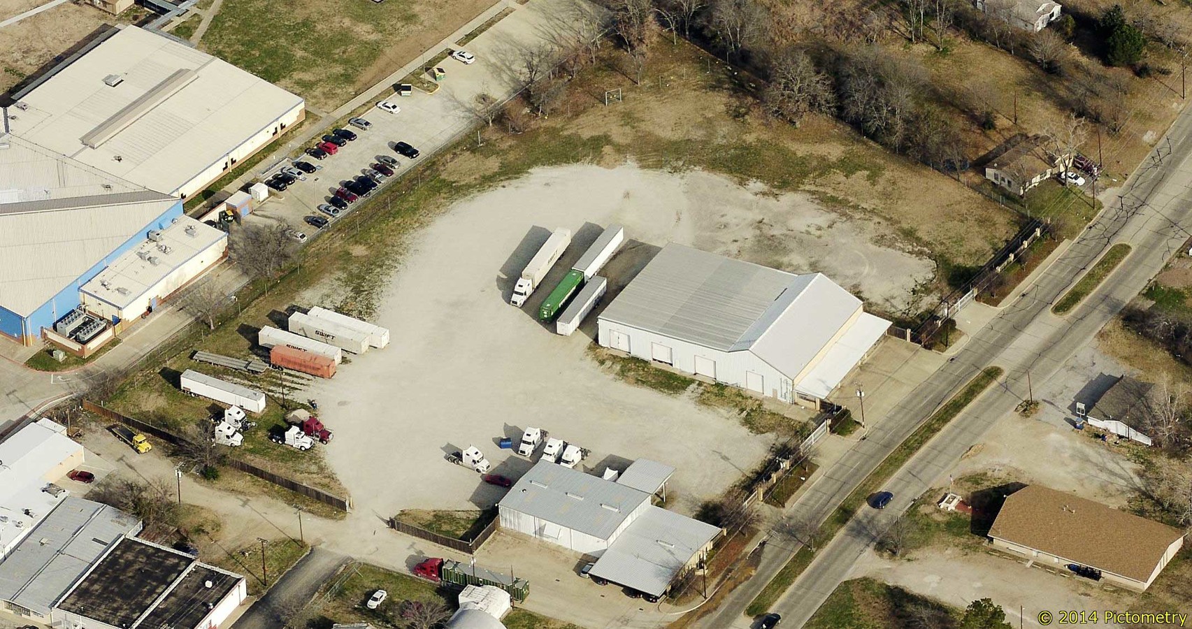
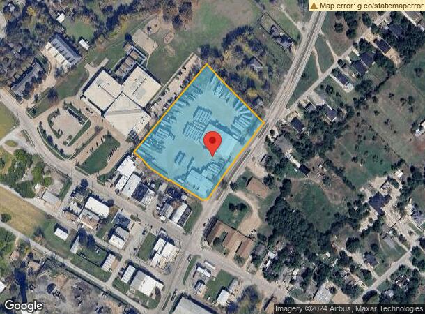
Property Record
111 E Malloy Bridge Rd, Seagoville, TX 75159
NEARBY LISTINGS FOR SALE OR LEASE
Property Detail
111 E Malloy Bridge Rd
65017810550210000
Henry D Bohannan
Warehouse
HENRY D BOHANNAN ABST 178 PG 105 TR 21 ACS 4.557 LOC ORIG TOWN SEAGOVILLE SHEET 7 INT202100141831 DD05102021 CO-DC 0178105502100 4CJ01781055
X
Dallas
48257C0150E
Texas
2023
4.56 AC
2023
SE Dallas/I-45
017006
Dallas/Ft Worth
16,150 SF
Dallas-Fort Worth-Arlington, TX
DEMOGRAPHICS near 111 E Malloy Bridge Rd
1 Mile
3 Mile
5 Mile
2024 Total Population
4,616
15,263
46,476
2029 Population
4,606
15,290
48,057
Pop Growth 2024-2029
(0.22%)
+ 0.18%
+ 3.40%
Average Age
40
37
33
2024 Total Households
1,176
4,272
13,031
HH Growth 2024-2029
(0.09%)
+ 0.23%
+ 3.73%
Median Household Inc
$54,626
$52,695
$53,305
Avg Household Size
3.00
3.10
3.30
2024 Avg HH Vehicles
2.00
2.00
2.00
Median Home Value
$222,487
$183,610
$181,119
Median Year Built
1983
1989
1998
Nearby Places
- Restaurants
- Banks
- Shops
- Fitness
- Groceries
PUBLIC TRANSPORTATION
AIRPORT
Dallas Love Field
DRIVE
WALK
Distance
Dallas Love Field
35 min
25.2 mi
Freight Ports
Port of Shreveport
DRIVE
WALK
Distance
Port of Shreveport
197 min
182.5 mi
SALE & LEASE HISTORY
LISTING DATE
SALE/LEASE

May 14, 2019
For Sale
Dec 06, 2016
For Sale
Nearby Properties
Address
Land Use
TOTAL SIZE
Lot Size
Zoning
Address
Land Use
TOTAL SIZE
Lot Size
Zoning
106,462 SF
9.58 AC
Z236
Address
Land Use
TOTAL SIZE
Lot Size
Zoning
319 SF
37.74 AC
SUP1
Address
Land Use
TOTAL SIZE
Lot Size
Zoning
377,133 SF
16.71 AC
Z131
Address
Land Use
TOTAL SIZE
Lot Size
Zoning
172,068 SF
17.25 AC
Z137
Address
Land Use
TOTAL SIZE
Lot Size
Zoning
88,320 SF
4.48 AC
Z72
Address
Land Use
TOTAL SIZE
Lot Size
Zoning
65,577 SF
11.80 AC
Z31
Address
Land Use
TOTAL SIZE
Lot Size
Zoning
108 SF
14.44 AC
Z31
Address
Land Use
TOTAL SIZE
Lot Size
Zoning
75,908 SF
11.11 AC
Z308
Address
Land Use
TOTAL SIZE
Lot Size
Zoning
28,126 SF
166.45 AC
Z05
Address
Land Use
TOTAL SIZE
Lot Size
Zoning
92 SF
11.39 AC
SUP12
Address
Land Use
TOTAL SIZE
Lot Size
Zoning
83,266 SF
6.73 AC
Z131
Address
Land Use
TOTAL SIZE
Lot Size
Zoning
51,770 SF
7.61 AC
Z31
Address
Land Use
TOTAL SIZE
Lot Size
Zoning
94,615 SF
3.34 AC
Z399
Address
Land Use
TOTAL SIZE
Lot Size
Zoning
19,670 SF
1.95 AC
Z137
Address
Land Use
TOTAL SIZE
Lot Size
Zoning
52,480 SF
103.55 AC
Address
Land Use
TOTAL SIZE
Lot Size
Zoning
100,200 SF
6.93 AC
Z05
Address
Land Use
TOTAL SIZE
Lot Size
Zoning
750 SF
115.63 AC
Z31
Address
Land Use
TOTAL SIZE
Lot Size
Zoning
750 SF
115.63 AC
Z31
Address
Land Use
TOTAL SIZE
Lot Size
Zoning
0.01 AC
Z306
Address
Land Use
TOTAL SIZE
Lot Size
Zoning
22,870 SF
1.14 AC
Z31
Address
Land Use
TOTAL SIZE
Lot Size
Zoning
64,420 SF
8.91 AC
Z131
Address
Land Use
TOTAL SIZE
Lot Size
Zoning
50,872 SF
4.99 AC
Z137
Address
Land Use
TOTAL SIZE
Lot Size
Zoning
41,865 SF
20.04 AC
Z308
Address
Land Use
TOTAL SIZE
Lot Size
Zoning
24,990 SF
3.36 AC
Z137
Address
Land Use
TOTAL SIZE
Lot Size
Zoning
20,400 SF
1.99 AC
Z137
Address
Land Use
TOTAL SIZE
Lot Size
Zoning
218 SF
Z236
Address
Land Use
TOTAL SIZE
Lot Size
Zoning
79,200 SF
7.26 AC
Z31
Address
Land Use
TOTAL SIZE
Lot Size
Zoning
14,838 SF
1.89 AC
Z137
Address
Land Use
TOTAL SIZE
Lot Size
Zoning
131.99 AC
Z05
Address
Land Use
TOTAL SIZE
Lot Size
Zoning
5,600 SF
1.68 AC
Z31
The World's #1 Commercial Real Estate Marketplace
Connect with us
© 2025 CoStar Group
The information above has been obtained from sources believed reliable. While we do not doubt its accuracy we have not verified it and make no guarantee, warranty or representation about it. It is your responsibility to independently confirm its accuracy and completeness. Any projections, opinions, assumptions, or estimates used are for example only and do not represent the current or future performance of the property. The value of this transaction to you depends on tax and other factors which should be evaluated by your tax, financial, and legal advisors. You and your advisors should conduct a careful, independent investigation of the property to determine to your satisfaction the suitability of the property for your needs.