Property Record
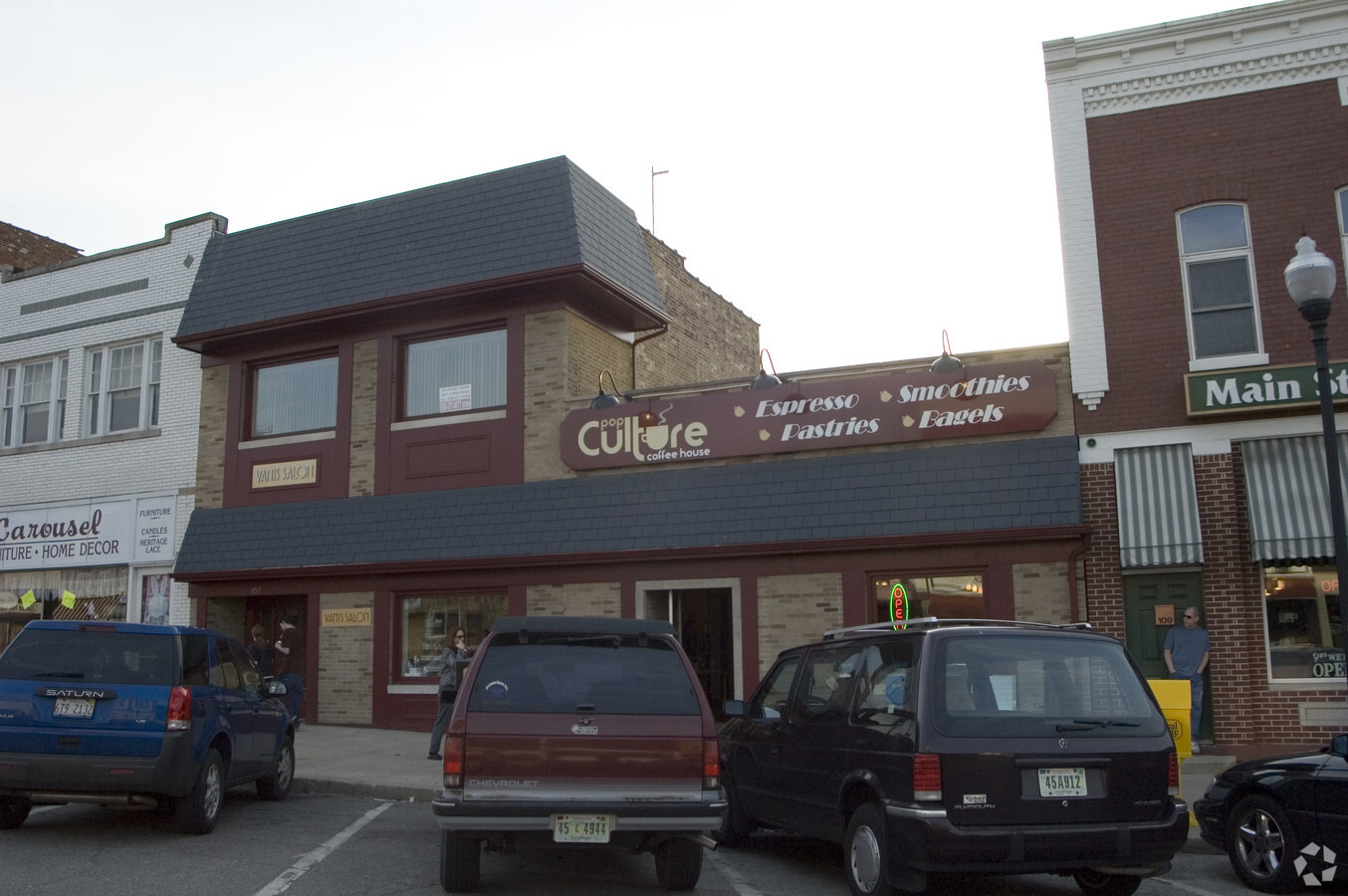
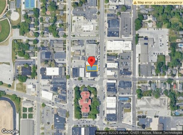
107 N Main St, Crown Point, IN 46307
NEARBY LISTINGS FOR SALE OR LEASE
Property Detail
107 N Main St
Chicago-Naperville-Elgin, IL-IN-WI
Original Town
45-16-08-132-019.000-042
ORIGINAL TOWN OF CROWN POINT N.24FT. OF E.105FT. LOT 15 S.28 1/2FT. OF E. 105FT. LOT 16
Officebuilding
Lake
X
Indiana
18089C0261E
15,16
2023
0.13 AC
2024
Indiana
043004
Chicago
10,375 SF
DEMOGRAPHICS near 107 N Main St
1 Mile
3 Mile
5 Mile
2024 Total Population
9,065
40,336
86,051
2029 Population
9,040
40,457
86,493
Pop Growth 2024-2029
(0.28%)
+ 0.30%
+ 0.51%
Average Age
42
42
41
2024 Total Households
3,697
15,445
33,169
HH Growth 2024-2029
(0.30%)
+ 0.27%
+ 0.49%
Median Household Inc
$70,973
$88,709
$81,370
Avg Household Size
2.40
2.50
2.50
2024 Avg HH Vehicles
2.00
2.00
2.00
Median Home Value
$226,663
$261,703
$253,925
Median Year Built
1968
1991
1990
Nearby Places
- Restaurants
- Banks
- Shops
- Fitness
- Groceries
Nearby Properties
Address
Land Use
TOTAL SIZE
Lot Size
Zoning
Address
Land Use
TOTAL SIZE
Lot Size
Zoning
642,771 SF
37.52 AC
Address
Land Use
TOTAL SIZE
Lot Size
Zoning
129,204 SF
16.57 AC
Address
Land Use
TOTAL SIZE
Lot Size
Zoning
377,878 SF
21.58 AC
Address
Land Use
TOTAL SIZE
Lot Size
Zoning
184,544 SF
16.76 AC
Address
Land Use
TOTAL SIZE
Lot Size
Zoning
324,724 SF
17.30 AC
Address
Land Use
TOTAL SIZE
Lot Size
Zoning
111,453 SF
15.21 AC
Address
Land Use
TOTAL SIZE
Lot Size
Zoning
263,968 SF
27.86 AC
Address
Land Use
TOTAL SIZE
Lot Size
Zoning
1,002,000 SF
60.96 AC
Address
Land Use
TOTAL SIZE
Lot Size
Zoning
304,425 SF
18.45 AC
Address
Land Use
TOTAL SIZE
Lot Size
Zoning
133,291 SF
R33
Address
Land Use
TOTAL SIZE
Lot Size
Zoning
276,540 SF
21.16 AC
Address
Land Use
TOTAL SIZE
Lot Size
Zoning
143,060 SF
33.82 AC
Address
Land Use
TOTAL SIZE
Lot Size
Zoning
89,578 SF
2.59 AC
Address
Land Use
TOTAL SIZE
Lot Size
Zoning
63,992 SF
8.07 AC
Address
Land Use
TOTAL SIZE
Lot Size
Zoning
40,890 SF
11.27 AC
Address
Land Use
TOTAL SIZE
Lot Size
Zoning
123,316 SF
14.88 AC
R33
Address
Land Use
TOTAL SIZE
Lot Size
Zoning
61,318 SF
15.79 AC
R33
Address
Land Use
TOTAL SIZE
Lot Size
Zoning
92,823 SF
8.56 AC
Address
Land Use
TOTAL SIZE
Lot Size
Zoning
94,527 SF
6.10 AC
R33
Address
Land Use
TOTAL SIZE
Lot Size
Zoning
59,824 SF
5.29 AC
R33
Address
Land Use
TOTAL SIZE
Lot Size
Zoning
71,786 SF
9.20 AC
R33
Address
Land Use
TOTAL SIZE
Lot Size
Zoning
55,149 SF
2.76 AC
Address
Land Use
TOTAL SIZE
Lot Size
Zoning
85,898 SF
18.29 AC
R33
Address
Land Use
TOTAL SIZE
Lot Size
Zoning
48,658 SF
6.64 AC
R33
Address
Land Use
TOTAL SIZE
Lot Size
Zoning
63,336 SF
4.54 AC
R33
Address
Land Use
TOTAL SIZE
Lot Size
Zoning
122,908 SF
9.58 AC
Address
Land Use
TOTAL SIZE
Lot Size
Zoning
34,704 SF
4.64 AC
Address
Land Use
TOTAL SIZE
Lot Size
Zoning
32,161 SF
3.99 AC
Address
Land Use
TOTAL SIZE
Lot Size
Zoning
113,942 SF
13 AC
Address
Land Use
TOTAL SIZE
Lot Size
Zoning
171,123 SF
10.90 AC
The World's #1 Commercial Real Estate Marketplace
Connect with us
© 2025 CoStar Group
The information above has been obtained from sources believed reliable. While we do not doubt its accuracy we have not verified it and make no guarantee, warranty or representation about it. It is your responsibility to independently confirm its accuracy and completeness. Any projections, opinions, assumptions, or estimates used are for example only and do not represent the current or future performance of the property. The value of this transaction to you depends on tax and other factors which should be evaluated by your tax, financial, and legal advisors. You and your advisors should conduct a careful, independent investigation of the property to determine to your satisfaction the suitability of the property for your needs.