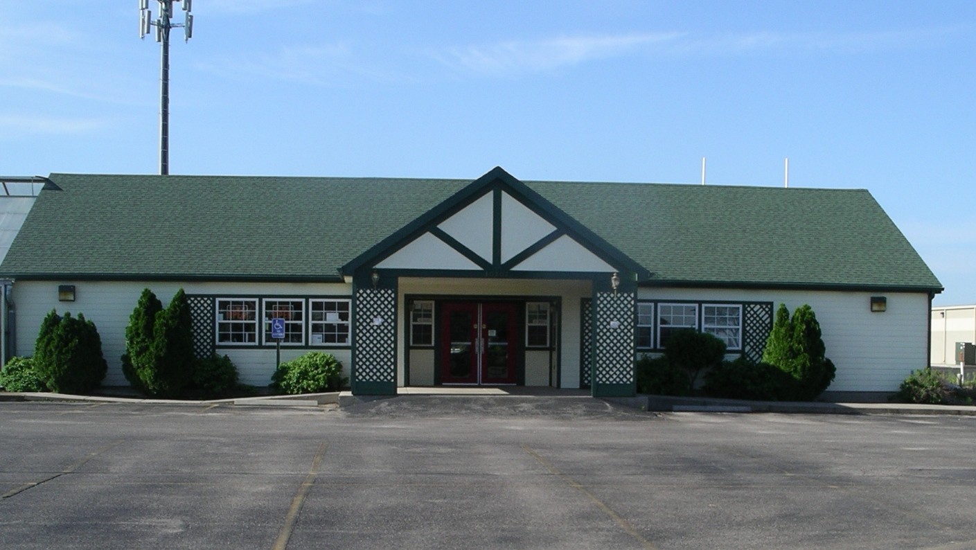
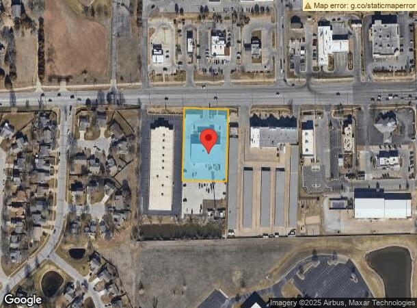
Property Record
10707 W 21St St N, Wichita, KS 67205
NEARBY LISTINGS FOR SALE OR LEASE
Property Detail
10707 W 21St St N
Wichita, KS
Pearson Farms Add
133-07-0-11-01-004.00
LOT 2 PEARSON FARMS ADD.
Autorepair
Sedgwick
X
Kansas
20173C0327G
2
2023
1.50 AC
2023
Goddard/West
009506
Wichita
14,628 SF
DEMOGRAPHICS near 10707 W 21St St N
1 Mile
3 Mile
5 Mile
2024 Total Population
10,885
59,943
106,179
2029 Population
10,856
60,367
107,566
Pop Growth 2024-2029
(0.27%)
+ 0.71%
+ 1.31%
Average Age
40
40
40
2024 Total Households
3,995
23,489
41,462
HH Growth 2024-2029
(0.30%)
+ 0.68%
+ 1.32%
Median Household Inc
$88,356
$81,181
$75,353
Avg Household Size
2.60
2.50
2.50
2024 Avg HH Vehicles
2.00
2.00
2.00
Median Home Value
$203,226
$220,895
$200,373
Median Year Built
1991
1990
1989
Nearby Places
- Restaurants
- Banks
- Shops
- Fitness
- Groceries
PUBLIC TRANSPORTATION
AIRPORT
Wichita Dwight D Eisenhower Ntl
DRIVE
WALK
Distance
Wichita Dwight D Eisenhower Ntl
15 min
7.7 mi
Freight Ports
Tulsa Port Of Catoosa
DRIVE
WALK
Distance
Tulsa Port Of Catoosa
216 min
200.7 mi
SALE & LEASE HISTORY
LISTING DATE
SALE/LEASE

Mar 26, 2019
For Sale
Mar 15, 2018
For Sale
Nearby Properties
Address
Land Use
TOTAL SIZE
Lot Size
Zoning
Address
Land Use
TOTAL SIZE
Lot Size
Zoning
662,237 SF
179.74 AC
SF-5
Address
Land Use
TOTAL SIZE
Lot Size
Zoning
149,756 SF
65.60 AC
SF-5
Address
Land Use
TOTAL SIZE
Lot Size
Zoning
143,939 SF
10.88 AC
PUD
Address
Land Use
TOTAL SIZE
Lot Size
Zoning
303,559 SF
127.81 AC
SF-5
Address
Land Use
TOTAL SIZE
Lot Size
Zoning
82,854 SF
49.09 AC
LC,SF-5
Address
Land Use
TOTAL SIZE
Lot Size
Zoning
102,794 SF
14.78 AC
SF-5
Address
Land Use
TOTAL SIZE
Lot Size
Zoning
143,704 SF
19.22 AC
SF-5
Address
Land Use
TOTAL SIZE
Lot Size
Zoning
136,717 SF
11.18 AC
SF-5
Address
Land Use
TOTAL SIZE
Lot Size
Zoning
70,821 SF
9.98 AC
SF-5
Address
Land Use
TOTAL SIZE
Lot Size
Zoning
38,927 SF
5.35 AC
LC
Address
Land Use
TOTAL SIZE
Lot Size
Zoning
79,775 SF
7.94 AC
SF-5
Address
Land Use
TOTAL SIZE
Lot Size
Zoning
173,604 SF
21.29 AC
LC
Address
Land Use
TOTAL SIZE
Lot Size
Zoning
65,504 SF
6.81 AC
SF-5
Address
Land Use
TOTAL SIZE
Lot Size
Zoning
62,321 SF
13.21 AC
SF-5
Address
Land Use
TOTAL SIZE
Lot Size
Zoning
51,845 SF
5.51 AC
SF-5
Address
Land Use
TOTAL SIZE
Lot Size
Zoning
47,158 SF
211.18 AC
SF-20,LC
Address
Land Use
TOTAL SIZE
Lot Size
Zoning
60,085 SF
7.37 AC
SF-5
Address
Land Use
TOTAL SIZE
Lot Size
Zoning
34,963 SF
6.13 AC
Address
Land Use
TOTAL SIZE
Lot Size
Zoning
65,110 SF
3.94 AC
B
Address
Land Use
TOTAL SIZE
Lot Size
Zoning
33,953 SF
10.05 AC
SF-5
Address
Land Use
TOTAL SIZE
Lot Size
Zoning
56,821 SF
2.68 AC
SF-5
Address
Land Use
TOTAL SIZE
Lot Size
Zoning
37,055 SF
19.24 AC
SF-20
Address
Land Use
TOTAL SIZE
Lot Size
Zoning
87.72 AC
SF-5
Address
Land Use
TOTAL SIZE
Lot Size
Zoning
24,134 SF
8.78 AC
B1
Address
Land Use
TOTAL SIZE
Lot Size
Zoning
45,085 SF
6.35 AC
SF-5
Address
Land Use
TOTAL SIZE
Lot Size
Zoning
39,299 SF
4.82 AC
SF-5
Address
Land Use
TOTAL SIZE
Lot Size
Zoning
46,007 SF
13.19 AC
MF-29
Address
Land Use
TOTAL SIZE
Lot Size
Zoning
94,866 SF
7.40 AC
LC
Address
Land Use
TOTAL SIZE
Lot Size
Zoning
19,148 SF
4.46 AC
LI
Address
Land Use
TOTAL SIZE
Lot Size
Zoning
31,411 SF
3.98 AC
SF-5
The World's #1 Commercial Real Estate Marketplace
Connect with us
© 2025 CoStar Group
The information above has been obtained from sources believed reliable. While we do not doubt its accuracy we have not verified it and make no guarantee, warranty or representation about it. It is your responsibility to independently confirm its accuracy and completeness. Any projections, opinions, assumptions, or estimates used are for example only and do not represent the current or future performance of the property. The value of this transaction to you depends on tax and other factors which should be evaluated by your tax, financial, and legal advisors. You and your advisors should conduct a careful, independent investigation of the property to determine to your satisfaction the suitability of the property for your needs.