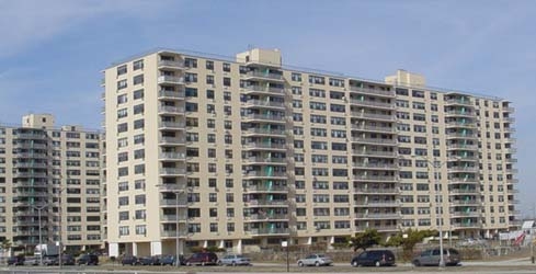
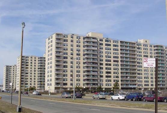
Property Record
10710 Shore Front Pky, Rockaway Park, NY 11694
NEARBY LISTINGS FOR SALE OR LEASE
Property Detail
10710 Shore Front Pky
16177-0001
Queens
Apartment
New York
X
55
3604970379F
4.48 AC
2024
Rockaway Park
2024
Long Island (New York)
093402
New York-Jersey City-White Plains, NY-NJ
293,677 SF
DEMOGRAPHICS near 10710 Shore Front Pky
1 Mile
3 Mile
5 Mile
2024 Total Population
19,237
58,497
143,815
2029 Population
18,377
55,124
135,431
Pop Growth 2024-2029
(4.47%)
(5.77%)
(5.83%)
Average Age
45
42
40
2024 Total Households
8,122
21,883
50,671
HH Growth 2024-2029
(4.40%)
(5.88%)
(5.92%)
Median Household Inc
$66,301
$61,387
$60,733
Avg Household Size
2.20
2.50
2.60
2024 Avg HH Vehicles
1.00
1.00
1.00
Median Home Value
$510,687
$622,785
$688,464
Median Year Built
1965
1965
1964
Nearby Places
- Restaurants
- Banks
- Shops
- Fitness
- Groceries
PUBLIC TRANSPORTATION
TRANSIT/SUBWAY
Beach 105 Street (A - New York MTA Subway (The Subway), Rockaway Park Shuttle - New York MTA Subway (The Subway))
DRIVE
WALK
Distance
Beach 105 Street (A - New York MTA Subway (The Subway), Rockaway Park Shuttle - New York MTA Subway (The Subway))
2 min
8 min
0.4 mi
Rockaway Park-Beach 116 Street (A - New York MTA Subway (The Subway), Rockaway Park Shuttle - New York MTA Subway (The Subway))
DRIVE
WALK
Distance
Rockaway Park-Beach 116 Street (A - New York MTA Subway (The Subway), Rockaway Park Shuttle - New York MTA Subway (The Subway))
3 min
12 min
0.6 mi
Beach 98 Street (A - New York MTA Subway (The Subway), Rockaway Park Shuttle - New York MTA Subway (The Subway))
DRIVE
WALK
Distance
Beach 98 Street (A - New York MTA Subway (The Subway), Rockaway Park Shuttle - New York MTA Subway (The Subway))
3 min
13 min
0.7 mi
Beach 90 Street (A - New York MTA Subway (The Subway), Rockaway Park Shuttle - New York MTA Subway (The Subway))
DRIVE
WALK
Distance
Beach 90 Street (A - New York MTA Subway (The Subway), Rockaway Park Shuttle - New York MTA Subway (The Subway))
3 min
20 min
1.1 mi
COMMUTER RAIL
Far Rockaway Station (Far Rockaway Branch - Long Island Rail Road)
DRIVE
WALK
Distance
Far Rockaway Station (Far Rockaway Branch - Long Island Rail Road)
11 min
5.1 mi
Inwood Station (Far Rockaway Branch - Long Island Rail Road)
DRIVE
WALK
Distance
Inwood Station (Far Rockaway Branch - Long Island Rail Road)
12 min
6.5 mi
AIRPORT
John F Kennedy International
DRIVE
WALK
Distance
John F Kennedy International
23 min
11.7 mi
Laguardia
DRIVE
WALK
Distance
Laguardia
34 min
18.5 mi
Newark Liberty International
DRIVE
WALK
Distance
Newark Liberty International
55 min
33.3 mi
Freight Ports
NY - Red Hook Container Terminal
DRIVE
WALK
Distance
NY - Red Hook Container Terminal
33 min
15.8 mi
Nearby Properties
Address
Land Use
TOTAL SIZE
Lot Size
Zoning
Address
Land Use
TOTAL SIZE
Lot Size
Zoning
477.04 AC
PARKUS
Address
Land Use
TOTAL SIZE
Lot Size
Zoning
65.94 AC
PARKUS
Address
Land Use
TOTAL SIZE
Lot Size
Zoning
72,663 SF
264.48 AC
PARK
Address
Land Use
TOTAL SIZE
Lot Size
Zoning
200.83 AC
PARK
Address
Land Use
TOTAL SIZE
Lot Size
Zoning
50,000 SF
149.22 AC
PARK
Address
Land Use
TOTAL SIZE
Lot Size
Zoning
42.84 AC
PARK
Address
Land Use
TOTAL SIZE
Lot Size
Zoning
1,085,148 SF
13.53 AC
R6
Address
Land Use
TOTAL SIZE
Lot Size
Zoning
407,218 SF
34.48 AC
R4
Address
Land Use
TOTAL SIZE
Lot Size
Zoning
820,910 SF
21.03 AC
R4
Address
Land Use
TOTAL SIZE
Lot Size
Zoning
18.71 AC
PARKUS
Address
Land Use
TOTAL SIZE
Lot Size
Zoning
20,000 SF
172.95 AC
PARK
Address
Land Use
TOTAL SIZE
Lot Size
Zoning
145,883 SF
1.29 AC
R6
Address
Land Use
TOTAL SIZE
Lot Size
Zoning
72,148 SF
0.44 AC
R6A
Address
Land Use
TOTAL SIZE
Lot Size
Zoning
587,170 SF
13.55 AC
R4
Address
Land Use
TOTAL SIZE
Lot Size
Zoning
120,994 SF
1.71 AC
R6
Address
Land Use
TOTAL SIZE
Lot Size
Zoning
666,256 SF
14.16 AC
R6
Address
Land Use
TOTAL SIZE
Lot Size
Zoning
3,120 SF
20.62 AC
PARK
Address
Land Use
TOTAL SIZE
Lot Size
Zoning
128,000 SF
2.52 AC
R5
Address
Land Use
TOTAL SIZE
Lot Size
Zoning
358,140 SF
8.13 AC
R5
Address
Land Use
TOTAL SIZE
Lot Size
Zoning
13.76 AC
PARK
Address
Land Use
TOTAL SIZE
Lot Size
Zoning
119,875 SF
3.16 AC
R4
Address
Land Use
TOTAL SIZE
Lot Size
Zoning
102,204 SF
2.32 AC
R6
Address
Land Use
TOTAL SIZE
Lot Size
Zoning
24,000,000 SF
55.42 AC
PARK
Address
Land Use
TOTAL SIZE
Lot Size
Zoning
290,070 SF
5.29 AC
R5
Address
Land Use
TOTAL SIZE
Lot Size
Zoning
93,023 SF
3.17 AC
R4
Address
Land Use
TOTAL SIZE
Lot Size
Zoning
292,677 SF
4.90 AC
R5
Address
Land Use
TOTAL SIZE
Lot Size
Zoning
141,500 SF
3.68 AC
R4
Address
Land Use
TOTAL SIZE
Lot Size
Zoning
64,415 SF
1.14 AC
R5
Address
Land Use
TOTAL SIZE
Lot Size
Zoning
38,485 SF
2.76 AC
R6
The World's #1 Commercial Real Estate Marketplace
Connect with us
© 2025 CoStar Group
The information above has been obtained from sources believed reliable. While we do not doubt its accuracy we have not verified it and make no guarantee, warranty or representation about it. It is your responsibility to independently confirm its accuracy and completeness. Any projections, opinions, assumptions, or estimates used are for example only and do not represent the current or future performance of the property. The value of this transaction to you depends on tax and other factors which should be evaluated by your tax, financial, and legal advisors. You and your advisors should conduct a careful, independent investigation of the property to determine to your satisfaction the suitability of the property for your needs.