Property Record
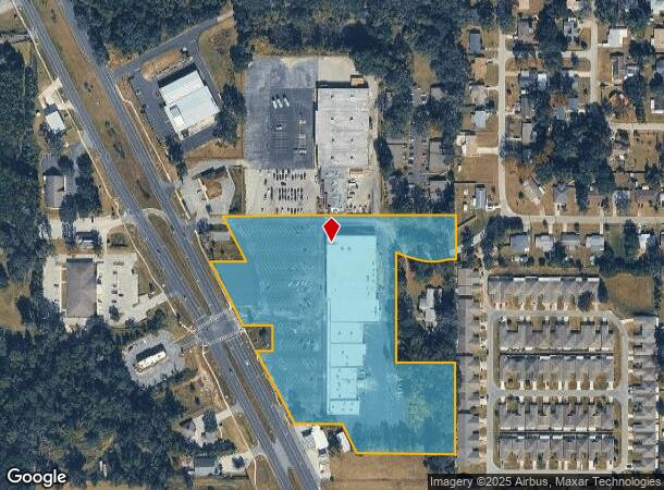
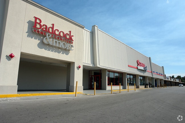
10737 Se Us Highway 441, Belleview, FL 34420

NEARBY LISTINGS FOR SALE OR LEASE
Property Detail
10737 Se Us Highway 441
37140-000-00
SEC 25 TWP 16 RGE 22 COM AT THE SE COR OF NW 1/4 OF SW 1/4 OF SEC 25 TH N 00-10-02 E 6.13 FT TO THE POB TH CONT N 00-10-02 E 150 FT TH N 89-49-50 W 736.02 FT TH S 26-34-00 E 160 FT TH N 89-49-50 W 100 FT TH S 26-34-00 E 233 FT TH S 89-49-50 E 85 FT T
Regionalshoppingcenterormallwithanchorstore
Marion
AE
Florida
12083C0729D
9 AC
2025
Outlying Marion County
2025
Ocala
001105
Ocala, FL
74,504 SF
DEMOGRAPHICS near 10737 Se Us Highway 441
1 Mile
3 Mile
5 Mile
2024 Total Population
4,623
20,587
59,789
2029 Population
5,265
23,384
68,051
Pop Growth 2024-2029
+ 13.89%
+ 13.59%
+ 13.82%
Average Age
42
41
42
2024 Total Households
1,870
8,133
23,622
HH Growth 2024-2029
+ 13.85%
+ 13.53%
+ 13.68%
Median Household Inc
$52,388
$57,451
$57,142
Avg Household Size
2.40
2.50
2.50
2024 Avg HH Vehicles
2.00
2.00
2.00
Median Home Value
$187,163
$186,778
$180,690
Median Year Built
1987
1991
1994
Nearby Places
Map Layers
Map Styles
 Street
 Aerial
- Restaurants
- Banks
- Shops
- Fitness
- Groceries
SALE & LEASE HISTORY
LISTING DATE
SALE/LEASE

Jan 10, 2017
For Lease
Nearby Properties
Address
Land Use
TOTAL SIZE
Lot Size
Zoning
Address
Land Use
TOTAL SIZE
Lot Size
Zoning
364,073 SF
119.27 AC
A1
Address
Land Use
TOTAL SIZE
Lot Size
Zoning
64,086 SF
28.11 AC
A1
Address
Land Use
TOTAL SIZE
Lot Size
Zoning
680,069 SF
62.96 AC
B5
Address
Land Use
TOTAL SIZE
Lot Size
Zoning
1,800 SF
954.07 AC
A1
Address
Land Use
TOTAL SIZE
Lot Size
Zoning
83,881 SF
16.60 AC
A1
Address
Land Use
TOTAL SIZE
Lot Size
Zoning
54,297 SF
6.32 AC
B2
Address
Land Use
TOTAL SIZE
Lot Size
Zoning
76,351 SF
14.60 AC
GU
Address
Land Use
TOTAL SIZE
Lot Size
Zoning
52,400 SF
6.50 AC
R3
Address
Land Use
TOTAL SIZE
Lot Size
Zoning
97,570 SF
13.29 AC
B2
Address
Land Use
TOTAL SIZE
Lot Size
Zoning
540 AC
A1
Address
Land Use
TOTAL SIZE
Lot Size
Zoning
28,457 SF
3.30 AC
B4
Address
Land Use
TOTAL SIZE
Lot Size
Zoning
30,862 SF
9.21 AC
B2
Address
Land Use
TOTAL SIZE
Lot Size
Zoning
501 SF
428.83 AC
B4
Address
Land Use
TOTAL SIZE
Lot Size
Zoning
45,804 SF
8 AC
B5
Address
Land Use
TOTAL SIZE
Lot Size
Zoning
52,572 SF
3.09 AC
B4
Address
Land Use
TOTAL SIZE
Lot Size
Zoning
43,281 SF
21.36 AC
B2
Address
Land Use
TOTAL SIZE
Lot Size
Zoning
66,190 SF
6.41 AC
B5
Address
Land Use
TOTAL SIZE
Lot Size
Zoning
13,858 SF
1.83 AC
B4
Address
Land Use
TOTAL SIZE
Lot Size
Zoning
99,544 SF
10 AC
M2
Address
Land Use
TOTAL SIZE
Lot Size
Zoning
13,608 SF
273.43 AC
A1
Address
Land Use
TOTAL SIZE
Lot Size
Zoning
8,194 SF
10.98 AC
A1
Address
Land Use
TOTAL SIZE
Lot Size
Zoning
18,213 SF
6.88 AC
GU
Address
Land Use
TOTAL SIZE
Lot Size
Zoning
43,882 SF
3.93 AC
B4
Address
Land Use
TOTAL SIZE
Lot Size
Zoning
45,000 SF
2.11 AC
B4
Address
Land Use
TOTAL SIZE
Lot Size
Zoning
60,978 SF
6.88 AC
PUD
Address
Land Use
TOTAL SIZE
Lot Size
Zoning
34,277 SF
14.94 AC
B5
Address
Land Use
TOTAL SIZE
Lot Size
Zoning
40,000 SF
4.06 AC
M1
Address
Land Use
TOTAL SIZE
Lot Size
Zoning
50,776 SF
12.05 AC
B2
Address
Land Use
TOTAL SIZE
Lot Size
Zoning
67,198 SF
9 AC
B5
Address
Land Use
TOTAL SIZE
Lot Size
Zoning
32,490 SF
2.52 AC
B4
The World's #1 Commercial Real Estate Marketplace
Connect with us
© 2026 CoStar Group
The information above has been obtained from sources believed reliable. While we do not doubt its accuracy we have not verified it and make no guarantee, warranty or representation about it. It is your responsibility to independently confirm its accuracy and completeness. Any projections, opinions, assumptions, or estimates used are for example only and do not represent the current or future performance of the property. The value of this transaction to you depends on tax and other factors which should be evaluated by your tax, financial, and legal advisors. You and your advisors should conduct a careful, independent investigation of the property to determine to your satisfaction the suitability of the property for your needs.