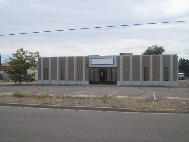
Property Record
108 W Walnut St, Brighton, CO 80601


NEARBY LISTINGS FOR SALE OR LEASE
Property Detail
108 W Walnut St
1569-06-3-13-013
Brighton Terrace Filing No 2
Warehouse
SUB:BRIGHTON TERRACE FILING NO 2 DESC: BEG 300 FT N OF SW COR TRACT B TH CONT N 330 FT TH ON ANG TO RT OF 94D 05M 143/05 FT TO PT OF CURVE TH ALG CURVE TO RT HAV RAD OF 450/42 FT C/A OF 14D 14M ARC DIST OF 111/96 FT TO P T TH ON ANG TO RT OF 90D 325/
X
Adams
08001C0327H
Colorado
2024
0.76 AC
2024
Northeast Denver
008603
Denver
6,540 SF
Denver-Aurora-Lakewood, CO
DEMOGRAPHICS near 108 W Walnut St
1 Mile
3 Mile
5 Mile
2024 Total Population
8,413
33,439
60,057
2029 Population
8,733
35,015
63,830
Pop Growth 2024-2029
+ 3.80%
+ 4.71%
+ 6.28%
Average Age
37
38
38
2024 Total Households
2,960
11,258
20,226
HH Growth 2024-2029
+ 3.78%
+ 4.92%
+ 6.42%
Median Household Inc
$61,348
$78,888
$96,685
Avg Household Size
2.80
2.90
2.90
2024 Avg HH Vehicles
2.00
2.00
2.00
Median Home Value
$396,611
$440,389
$484,066
Median Year Built
1971
1992
2003
Nearby Places
Map Layers
Map Styles
 Street
 Aerial
- Restaurants
- Banks
- Shops
- Fitness
- Groceries
PUBLIC TRANSPORTATION
AIRPORT
Denver International
DRIVE
WALK
Distance
Denver International
27 min
21.3 mi
SALE & LEASE HISTORY
LISTING DATE
SALE/LEASE

Aug 16, 2022
For Sale
Nearby Properties
Address
Land Use
TOTAL SIZE
Lot Size
Zoning
Address
Land Use
TOTAL SIZE
Lot Size
Zoning
413,138 SF
20.74 AC
Address
Land Use
TOTAL SIZE
Lot Size
Zoning
533,981 SF
112.40 AC
Address
Land Use
TOTAL SIZE
Lot Size
Zoning
161,096 SF
82.69 AC
Address
Land Use
TOTAL SIZE
Lot Size
Zoning
223,459 SF
27.46 AC
Address
Land Use
TOTAL SIZE
Lot Size
Zoning
274,367 SF
65.77 AC
Address
Land Use
TOTAL SIZE
Lot Size
Zoning
91,534 SF
23.03 AC
Address
Land Use
TOTAL SIZE
Lot Size
Zoning
85,398 SF
15 AC
Address
Land Use
TOTAL SIZE
Lot Size
Zoning
281,164 SF
15.57 AC
Address
Land Use
TOTAL SIZE
Lot Size
Zoning
182,210 SF
17.01 AC
Address
Land Use
TOTAL SIZE
Lot Size
Zoning
65,492 SF
7.50 AC
Address
Land Use
TOTAL SIZE
Lot Size
Zoning
175,091 SF
9.43 AC
Address
Land Use
TOTAL SIZE
Lot Size
Zoning
70,573 SF
7.83 AC
Address
Land Use
TOTAL SIZE
Lot Size
Zoning
52,000 SF
19.12 AC
Address
Land Use
TOTAL SIZE
Lot Size
Zoning
40,000 SF
4.10 AC
Address
Land Use
TOTAL SIZE
Lot Size
Zoning
566,409 SF
1.66 AC
Address
Land Use
TOTAL SIZE
Lot Size
Zoning
34,345 SF
13.11 AC
A1
Address
Land Use
TOTAL SIZE
Lot Size
Zoning
59,015 SF
9.44 AC
Address
Land Use
TOTAL SIZE
Lot Size
Zoning
260,526 SF
9.17 AC
Address
Land Use
TOTAL SIZE
Lot Size
Zoning
65,892 SF
4.87 AC
Address
Land Use
TOTAL SIZE
Lot Size
Zoning
95,310 SF
20.96 AC
A1
Address
Land Use
TOTAL SIZE
Lot Size
Zoning
67,405 SF
6.96 AC
Address
Land Use
TOTAL SIZE
Lot Size
Zoning
2,035 SF
93.30 AC
A1
Address
Land Use
TOTAL SIZE
Lot Size
Zoning
134,925 SF
3.67 AC
Address
Land Use
TOTAL SIZE
Lot Size
Zoning
61,640 SF
8.10 AC
Address
Land Use
TOTAL SIZE
Lot Size
Zoning
57,450 SF
30 AC
Address
Land Use
TOTAL SIZE
Lot Size
Zoning
37,470 SF
12.04 AC
Address
Land Use
TOTAL SIZE
Lot Size
Zoning
133,072 SF
12.32 AC
Address
Land Use
TOTAL SIZE
Lot Size
Zoning
80,560 SF
5.02 AC
Address
Land Use
TOTAL SIZE
Lot Size
Zoning
113,764 SF
4.24 AC
The World's #1 Commercial Real Estate Marketplace
Connect with us
© 2025 CoStar Group
The information above has been obtained from sources believed reliable. While we do not doubt its accuracy we have not verified it and make no guarantee, warranty or representation about it. It is your responsibility to independently confirm its accuracy and completeness. Any projections, opinions, assumptions, or estimates used are for example only and do not represent the current or future performance of the property. The value of this transaction to you depends on tax and other factors which should be evaluated by your tax, financial, and legal advisors. You and your advisors should conduct a careful, independent investigation of the property to determine to your satisfaction the suitability of the property for your needs.