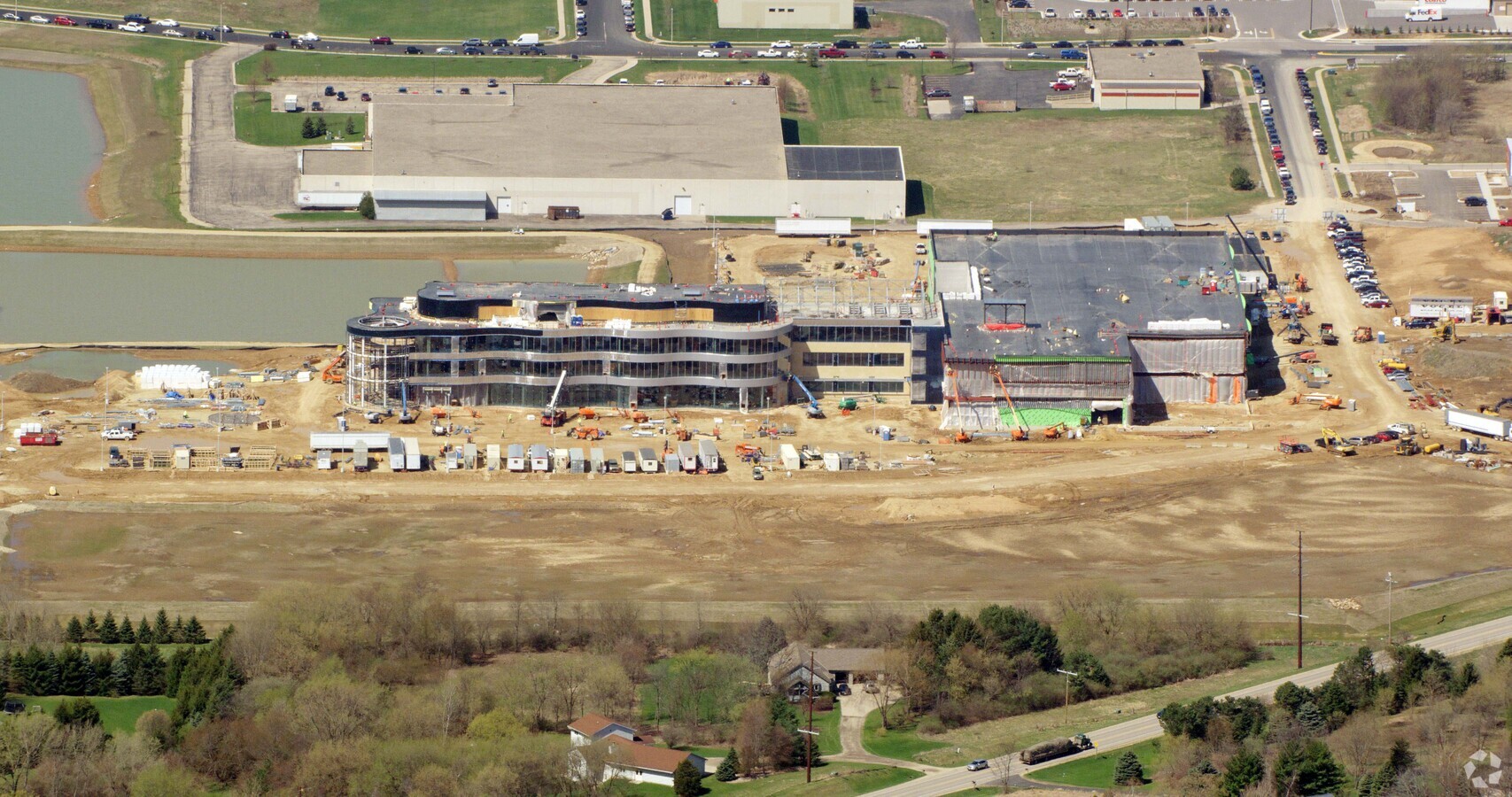
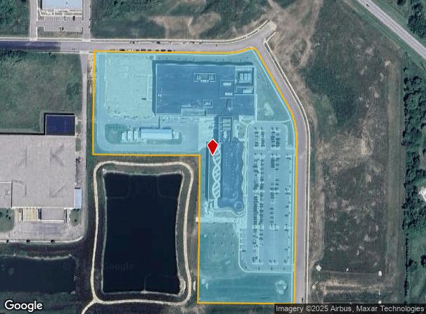
Property Record
1080 Arrowhead Way, , WI
NEARBY LISTINGS FOR SALE OR LEASE
Property Detail
1080 Arrowhead Way
Milwaukee/Madison
Certified Survey Map 15848 Recorded
Madison, WI
LOT 1 CSM 15848 CS115/340-343 11/02/2021 F/K/A SEC 25-6-8 NW1/4 NW1/4 EXC R473/2 83 & ALSO EXC CSM 12099 & F/K/A LOT 2 CSM 12099 CS74/295&299-3/28/2007 & F/K/A S EC 25-6-8 SW1/4 NW1/4 EXC CSM 12099 & ALSO EXC CSM 14505 (13.059 A)
0608-252-8710-2
Dane
Commercialnec
Wisconsin
2023
1
2023
13.06 AC
010702
Outlying Dane West
DEMOGRAPHICS near 1080 Arrowhead Way
1 Mile
3 Mile
5 Mile
2024 Total Population
588
20,519
69,972
2029 Population
612
21,421
72,596
Pop Growth 2024-2029
+ 4.08%
+ 4.40%
+ 3.75%
Average Age
35
38
38
2024 Total Households
217
8,351
28,604
HH Growth 2024-2029
+ 4.15%
+ 4.60%
+ 3.88%
Median Household Inc
$103,646
$102,907
$95,742
Avg Household Size
2.60
2.40
2.40
2024 Avg HH Vehicles
2.00
2.00
2.00
Median Home Value
$393,938
$354,245
$348,042
Median Year Built
2006
2000
1994
Nearby Places
- Restaurants
- Banks
- Shops
- Fitness
- Groceries
PUBLIC TRANSPORTATION
AIRPORT
Dane County Regional/Truax Field
DRIVE
WALK
Distance
Dane County Regional/Truax Field
31 min
16.1 mi
Freight Ports
Port Milwaukee
DRIVE
WALK
Distance
Port Milwaukee
112 min
92.8 mi
Nearby Properties
Address
Land Use
TOTAL SIZE
Lot Size
Zoning
Address
Land Use
TOTAL SIZE
Lot Size
Zoning
16.87 AC
SE
Address
Land Use
TOTAL SIZE
Lot Size
Zoning
77,296 SF
4.84 AC
TR-U1
Address
Land Use
TOTAL SIZE
Lot Size
Zoning
Address
Land Use
TOTAL SIZE
Lot Size
Zoning
17.80 AC
Address
Land Use
TOTAL SIZE
Lot Size
Zoning
Address
Land Use
TOTAL SIZE
Lot Size
Zoning
3.56 AC
Address
Land Use
TOTAL SIZE
Lot Size
Zoning
3.35 AC
Address
Land Use
TOTAL SIZE
Lot Size
Zoning
6.66 AC
Address
Land Use
TOTAL SIZE
Lot Size
Zoning
3.71 AC
Address
Land Use
TOTAL SIZE
Lot Size
Zoning
5.58 AC
Address
Land Use
TOTAL SIZE
Lot Size
Zoning
17.81 AC
Address
Land Use
TOTAL SIZE
Lot Size
Zoning
20,787 SF
4.56 AC
TR-U1
Address
Land Use
TOTAL SIZE
Lot Size
Zoning
4.07 AC
Address
Land Use
TOTAL SIZE
Lot Size
Zoning
3.62 AC
Address
Land Use
TOTAL SIZE
Lot Size
Zoning
6.32 AC
Address
Land Use
TOTAL SIZE
Lot Size
Zoning
142,001 SF
4.18 AC
SR-V2
Address
Land Use
TOTAL SIZE
Lot Size
Zoning
7.77 AC
Address
Land Use
TOTAL SIZE
Lot Size
Zoning
13.42 AC
Address
Land Use
TOTAL SIZE
Lot Size
Zoning
5.77 AC
Address
Land Use
TOTAL SIZE
Lot Size
Zoning
56,146 SF
1.33 AC
PD
Address
Land Use
TOTAL SIZE
Lot Size
Zoning
5.17 AC
Address
Land Use
TOTAL SIZE
Lot Size
Zoning
Address
Land Use
TOTAL SIZE
Lot Size
Zoning
79,759 SF
1.15 AC
PD
Address
Land Use
TOTAL SIZE
Lot Size
Zoning
72,894 SF
2.14 AC
SR-V2
Address
Land Use
TOTAL SIZE
Lot Size
Zoning
13,502 SF
1.63 AC
TR-U1
Address
Land Use
TOTAL SIZE
Lot Size
Zoning
1.08 AC
Address
Land Use
TOTAL SIZE
Lot Size
Zoning
2.16 AC
Address
Land Use
TOTAL SIZE
Lot Size
Zoning
Address
Land Use
TOTAL SIZE
Lot Size
Zoning
3.77 AC
The World's #1 Commercial Real Estate Marketplace
Connect with us
© 2025 CoStar Group
The information above has been obtained from sources believed reliable. While we do not doubt its accuracy we have not verified it and make no guarantee, warranty or representation about it. It is your responsibility to independently confirm its accuracy and completeness. Any projections, opinions, assumptions, or estimates used are for example only and do not represent the current or future performance of the property. The value of this transaction to you depends on tax and other factors which should be evaluated by your tax, financial, and legal advisors. You and your advisors should conduct a careful, independent investigation of the property to determine to your satisfaction the suitability of the property for your needs.