Property Record
10817 New Kings Rd, Jacksonville, FL 32219


NEARBY LISTINGS FOR SALE OR LEASE
Property Detail
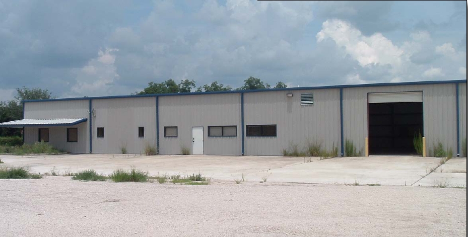
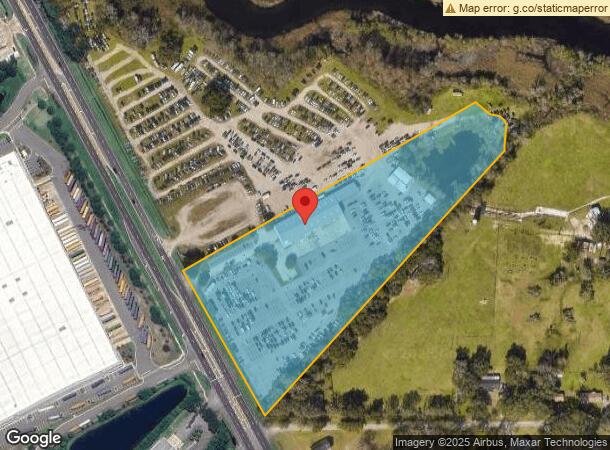
10817 New Kings Rd
003775-3000
Section Land
Warehouse
41-1S-25E 9.959 J RAIN & WM BAILEY GRANT PT RECD O/R 19540-981
AE
Duval
12031C0167J
Florida
2023
9.95 AC
2024
North Side
010502
Jacksonville (Florida)
20,388 SF
Jacksonville, FL
DEMOGRAPHICS near 10817 New Kings Rd
1 Mile
3 Mile
5 Mile
2024 Total Population
3,065
24,502
62,479
2029 Population
3,261
25,962
66,201
Pop Growth 2024-2029
+ 6.39%
+ 5.96%
+ 5.96%
Average Age
39
40
40
2024 Total Households
1,107
9,005
23,163
HH Growth 2024-2029
+ 6.59%
+ 6.09%
+ 6.05%
Median Household Inc
$77,981
$63,008
$52,627
Avg Household Size
2.70
2.60
2.60
2024 Avg HH Vehicles
2.00
2.00
2.00
Median Home Value
$178,009
$187,243
$175,491
Median Year Built
2002
1990
1979
Nearby Places
- Restaurants
- Banks
- Shops
- Fitness
- Groceries
PUBLIC TRANSPORTATION
COMMUTER RAIL
Jacksonville (Silver Meteor - Amtrak, Silver Star - Amtrak)
DRIVE
WALK
Distance
Jacksonville (Silver Meteor - Amtrak, Silver Star - Amtrak)
10 min
5.7 mi
AIRPORT
Jacksonville International
DRIVE
WALK
Distance
Jacksonville International
19 min
10.8 mi
Freight Ports
Jacksonville Port
DRIVE
WALK
Distance
Jacksonville Port
21 min
11.8 mi
Nearby Properties
Address
Land Use
TOTAL SIZE
Lot Size
Zoning
Address
Land Use
TOTAL SIZE
Lot Size
Zoning
647,378 SF
27.72 AC
IBP
Address
Land Use
TOTAL SIZE
Lot Size
Zoning
491,247 SF
30.77 AC
PUD
Address
Land Use
TOTAL SIZE
Lot Size
Zoning
375,130 SF
25.22 AC
IBP
Address
Land Use
TOTAL SIZE
Lot Size
Zoning
744.81 AC
PUD
Address
Land Use
TOTAL SIZE
Lot Size
Zoning
277,582 SF
16.49 AC
IL
Address
Land Use
TOTAL SIZE
Lot Size
Zoning
1,265.67 AC
PUD
Address
Land Use
TOTAL SIZE
Lot Size
Zoning
225,829 SF
140.47 AC
PBF-1
Address
Land Use
TOTAL SIZE
Lot Size
Zoning
171,572 SF
10.47 AC
PUD
Address
Land Use
TOTAL SIZE
Lot Size
Zoning
39,251 SF
55.24 AC
PUD
Address
Land Use
TOTAL SIZE
Lot Size
Zoning
178,080 SF
9.34 AC
IL
Address
Land Use
TOTAL SIZE
Lot Size
Zoning
80,622 SF
78.47 AC
PUD
Address
Land Use
TOTAL SIZE
Lot Size
Zoning
95,080 SF
9.35 AC
CRO
Address
Land Use
TOTAL SIZE
Lot Size
Zoning
79,407 SF
15.21 AC
PUD
Address
Land Use
TOTAL SIZE
Lot Size
Zoning
1,950 SF
72.15 AC
IBP
Address
Land Use
TOTAL SIZE
Lot Size
Zoning
49,120 SF
89.32 AC
CCG-2
Address
Land Use
TOTAL SIZE
Lot Size
Zoning
46.49 AC
PUD
Address
Land Use
TOTAL SIZE
Lot Size
Zoning
66,255 SF
40.55 AC
RR-ACRE
Address
Land Use
TOTAL SIZE
Lot Size
Zoning
13,214 SF
1.52 AC
PUD
Address
Land Use
TOTAL SIZE
Lot Size
Zoning
58,475 SF
5.33 AC
PUD
Address
Land Use
TOTAL SIZE
Lot Size
Zoning
5,839 SF
293.38 AC
PUD
Address
Land Use
TOTAL SIZE
Lot Size
Zoning
792 SF
9.18 AC
ROS
Address
Land Use
TOTAL SIZE
Lot Size
Zoning
16,030 SF
0.06 AC
CCG-1
Address
Land Use
TOTAL SIZE
Lot Size
Zoning
29.49 AC
PUD
Address
Land Use
TOTAL SIZE
Lot Size
Zoning
16,110 SF
0.06 AC
CCG-1
Address
Land Use
TOTAL SIZE
Lot Size
Zoning
58.58 AC
IH
Address
Land Use
TOTAL SIZE
Lot Size
Zoning
90.34 AC
PUD
Address
Land Use
TOTAL SIZE
Lot Size
Zoning
14,880 SF
0.06 AC
CCG-1
Address
Land Use
TOTAL SIZE
Lot Size
Zoning
12,963 SF
3.74 AC
CCG-2
Address
Land Use
TOTAL SIZE
Lot Size
Zoning
2,585 SF
7.42 AC
ROS
Address
Land Use
TOTAL SIZE
Lot Size
Zoning
28,799 SF
14.33 AC
PUD
The World's #1 Commercial Real Estate Marketplace
Connect with us
© 2025 CoStar Group
The information above has been obtained from sources believed reliable. While we do not doubt its accuracy we have not verified it and make no guarantee, warranty or representation about it. It is your responsibility to independently confirm its accuracy and completeness. Any projections, opinions, assumptions, or estimates used are for example only and do not represent the current or future performance of the property. The value of this transaction to you depends on tax and other factors which should be evaluated by your tax, financial, and legal advisors. You and your advisors should conduct a careful, independent investigation of the property to determine to your satisfaction the suitability of the property for your needs.