Property Record
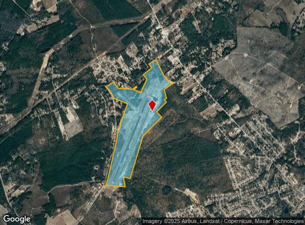
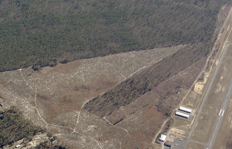
1083 Hartsville Airport Rd, Hartsville, SC 29550

NEARBY LISTINGS FOR SALE OR LEASE
-
-
View all Hartsville listings for sale on LoopNet.com
Property Detail
1083 Hartsville Airport Rd
Florence, SC
1083 HARTSVILLE AIRPORT
033-00-02-094
Darlington
Taxexempt
South Carolina
2023
212.50 AC
2024
South Carolina Rural Areas
010200
Other Market Areas
DEMOGRAPHICS near 1083 Hartsville Airport Rd
1 Mile
3 Mile
5 Mile
2024 Total Population
936
6,884
22,118
2029 Population
920
6,795
21,957
Pop Growth 2024-2029
(1.71%)
(1.29%)
(0.73%)
Average Age
42
42
41
2024 Total Households
386
2,795
8,981
HH Growth 2024-2029
(1.81%)
(1.25%)
(0.70%)
Median Household Inc
$52,321
$67,093
$53,707
Avg Household Size
2.40
2.40
2.30
2024 Avg HH Vehicles
2.00
2.00
2.00
Median Home Value
$166,911
$190,836
$152,405
Median Year Built
1992
1991
1983
Nearby Places
- Restaurants
- Banks
- Shops
- Fitness
- Groceries
SALE & LEASE HISTORY
LISTING DATE
SALE/LEASE

Jan 27, 2020
For Sale
Nearby Properties
Address
Land Use
TOTAL SIZE
Lot Size
Zoning
Address
Land Use
TOTAL SIZE
Lot Size
Zoning
12,000 SF
11 AC
Address
Land Use
TOTAL SIZE
Lot Size
Zoning
12,000 SF
5.40 AC
Address
Land Use
TOTAL SIZE
Lot Size
Zoning
3,354 SF
20 AC
Address
Land Use
TOTAL SIZE
Lot Size
Zoning
Address
Land Use
TOTAL SIZE
Lot Size
Zoning
Address
Land Use
TOTAL SIZE
Lot Size
Zoning
4,170 SF
0.60 AC
Address
Land Use
TOTAL SIZE
Lot Size
Zoning
5,000 SF
1.58 AC
Address
Land Use
TOTAL SIZE
Lot Size
Zoning
12,000 SF
1.80 AC
Address
Land Use
TOTAL SIZE
Lot Size
Zoning
2,249 SF
1.02 AC
Address
Land Use
TOTAL SIZE
Lot Size
Zoning
2.48 AC
Address
Land Use
TOTAL SIZE
Lot Size
Zoning
3,097 SF
2.62 AC
Address
Land Use
TOTAL SIZE
Lot Size
Zoning
2,444 SF
0.70 AC
Address
Land Use
TOTAL SIZE
Lot Size
Zoning
3,792 SF
1.84 AC
Address
Land Use
TOTAL SIZE
Lot Size
Zoning
2,054 SF
0.73 AC
Address
Land Use
TOTAL SIZE
Lot Size
Zoning
2,497 SF
0.49 AC
Address
Land Use
TOTAL SIZE
Lot Size
Zoning
34,298 SF
4 AC
Address
Land Use
TOTAL SIZE
Lot Size
Zoning
6.16 AC
Address
Land Use
TOTAL SIZE
Lot Size
Zoning
2,172 SF
2.77 AC
Address
Land Use
TOTAL SIZE
Lot Size
Zoning
1,661 SF
2.04 AC
Address
Land Use
TOTAL SIZE
Lot Size
Zoning
2,539 SF
0.50 AC
Address
Land Use
TOTAL SIZE
Lot Size
Zoning
2,210 SF
1.68 AC
Address
Land Use
TOTAL SIZE
Lot Size
Zoning
2,671 SF
1.32 AC
Address
Land Use
TOTAL SIZE
Lot Size
Zoning
1,480 SF
0.53 AC
Address
Land Use
TOTAL SIZE
Lot Size
Zoning
1,752 SF
0.57 AC
Address
Land Use
TOTAL SIZE
Lot Size
Zoning
2,545 SF
0.39 AC
Address
Land Use
TOTAL SIZE
Lot Size
Zoning
1,957 SF
2 AC
Address
Land Use
TOTAL SIZE
Lot Size
Zoning
1.58 AC
Address
Land Use
TOTAL SIZE
Lot Size
Zoning
1,902 SF
0.31 AC
Address
Land Use
TOTAL SIZE
Lot Size
Zoning
The World's #1 Commercial Real Estate Marketplace
Connect with us
© 2025 CoStar Group
The information above has been obtained from sources believed reliable. While we do not doubt its accuracy we have not verified it and make no guarantee, warranty or representation about it. It is your responsibility to independently confirm its accuracy and completeness. Any projections, opinions, assumptions, or estimates used are for example only and do not represent the current or future performance of the property. The value of this transaction to you depends on tax and other factors which should be evaluated by your tax, financial, and legal advisors. You and your advisors should conduct a careful, independent investigation of the property to determine to your satisfaction the suitability of the property for your needs.