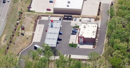
Property Record
10836 James Madison Hwy, Zion Crossroads, VA 22942
NEARBY LISTINGS FOR SALE OR LEASE
-
-
View all Zion Crossroads listings for sale on LoopNet.com
Property Detail
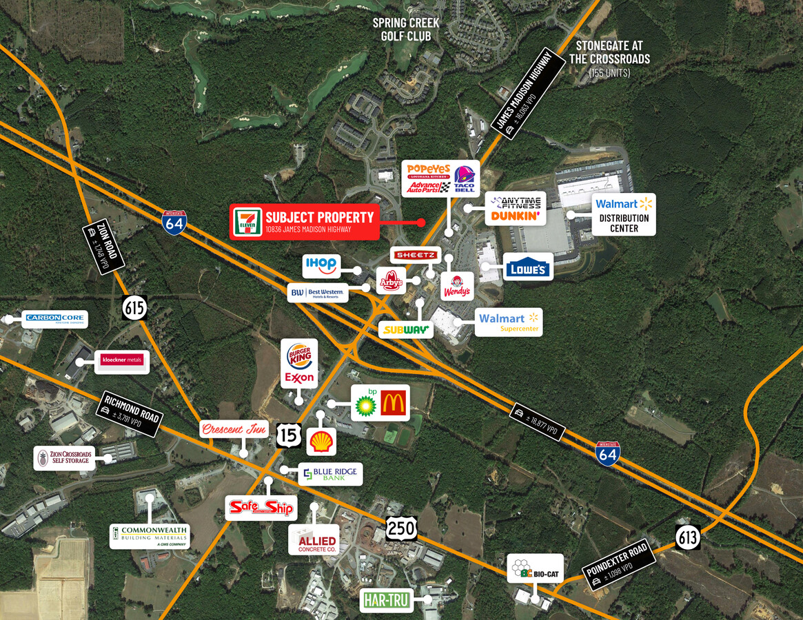
10836 James Madison Hwy
51-50
Division Survey Showing Parcel 50 As Sho
Commercialnec
CAMP CREEK & JACKSON PLAT 1162/936 DB 1834/653 2.002 AC
X
Louisa
51109C0275C
Virginia
2024
2 AC
2024
Louisa County
110302
Richmond VA
DEMOGRAPHICS near 10836 James Madison Hwy
1 Mile
3 Mile
5 Mile
2024 Total Population
1,183
5,270
9,096
2029 Population
1,357
5,972
10,195
Pop Growth 2024-2029
+ 14.71%
+ 13.32%
+ 12.08%
Average Age
43
43
43
2024 Total Households
493
1,914
3,213
HH Growth 2024-2029
+ 14.20%
+ 13.69%
+ 12.51%
Median Household Inc
$88,281
$94,521
$91,093
Avg Household Size
2.40
2.50
2.50
2024 Avg HH Vehicles
2.00
2.00
2.00
Median Home Value
$438,800
$376,895
$337,978
Median Year Built
2010
2006
2002
Nearby Places
- Restaurants
- Banks
- Shops
- Fitness
- Groceries
PUBLIC TRANSPORTATION
AIRPORT
Charlottesville-Albemarle
DRIVE
WALK
Distance
Charlottesville-Albemarle
35 min
20.2 mi
Freight Ports
Virginia Port Authority - Richmond
DRIVE
WALK
Distance
Virginia Port Authority - Richmond
91 min
73.4 mi
SALE & LEASE HISTORY
LISTING DATE
SALE/LEASE

Oct 11, 2021
For Sale
Nearby Properties
Address
Land Use
TOTAL SIZE
Lot Size
Zoning
Address
Land Use
TOTAL SIZE
Lot Size
Zoning
3,216 SF
9.93 AC
IND
Address
Land Use
TOTAL SIZE
Lot Size
Zoning
233.46 AC
IND
Address
Land Use
TOTAL SIZE
Lot Size
Zoning
170,632 SF
7.11 AC
M1 GENERAL
Address
Land Use
TOTAL SIZE
Lot Size
Zoning
39,859 SF
2.31 AC
B1 GENERAL
Address
Land Use
TOTAL SIZE
Lot Size
Zoning
186,934 SF
44.71 AC
I INDUSTRI
Address
Land Use
TOTAL SIZE
Lot Size
Zoning
9,960 SF
6.89 AC
R2 GENERAL
Address
Land Use
TOTAL SIZE
Lot Size
Zoning
30,820 SF
0.57 AC
B2 RESTRIC
Address
Land Use
TOTAL SIZE
Lot Size
Zoning
53,690 SF
24.61 AC
C2 GENERAL
Address
Land Use
TOTAL SIZE
Lot Size
Zoning
272.14 AC
A AGRICULT
Address
Land Use
TOTAL SIZE
Lot Size
Zoning
238.22 AC
A AGRICULT
Address
Land Use
TOTAL SIZE
Lot Size
Zoning
34,280 SF
4.79 AC
C2 GENERAL
Address
Land Use
TOTAL SIZE
Lot Size
Zoning
196 AC
I INDUSTRI
Address
Land Use
TOTAL SIZE
Lot Size
Zoning
10,380 SF
1.23 AC
B1 GENERAL
Address
Land Use
TOTAL SIZE
Lot Size
Zoning
18,472 SF
4 AC
R1 LIMITED
Address
Land Use
TOTAL SIZE
Lot Size
Zoning
181 AC
A AGRICULT
Address
Land Use
TOTAL SIZE
Lot Size
Zoning
15,360 SF
1.26 AC
B1 GENERAL
Address
Land Use
TOTAL SIZE
Lot Size
Zoning
11,048 SF
0.82 AC
B1 GENERAL
Address
Land Use
TOTAL SIZE
Lot Size
Zoning
141.98 AC
A AGRICULT
Address
Land Use
TOTAL SIZE
Lot Size
Zoning
6,337 SF
0.54 AC
R1 LIMITED
Address
Land Use
TOTAL SIZE
Lot Size
Zoning
6,138 SF
3.65 AC
R2 GENERAL
Address
Land Use
TOTAL SIZE
Lot Size
Zoning
1.60 AC
A2
Address
Land Use
TOTAL SIZE
Lot Size
Zoning
7,820 SF
12.84 AC
C2 GENERAL
Address
Land Use
TOTAL SIZE
Lot Size
Zoning
Address
Land Use
TOTAL SIZE
Lot Size
Zoning
5.37 AC
C2
The World's #1 Commercial Real Estate Marketplace
Connect with us
© 2025 CoStar Group
The information above has been obtained from sources believed reliable. While we do not doubt its accuracy we have not verified it and make no guarantee, warranty or representation about it. It is your responsibility to independently confirm its accuracy and completeness. Any projections, opinions, assumptions, or estimates used are for example only and do not represent the current or future performance of the property. The value of this transaction to you depends on tax and other factors which should be evaluated by your tax, financial, and legal advisors. You and your advisors should conduct a careful, independent investigation of the property to determine to your satisfaction the suitability of the property for your needs.