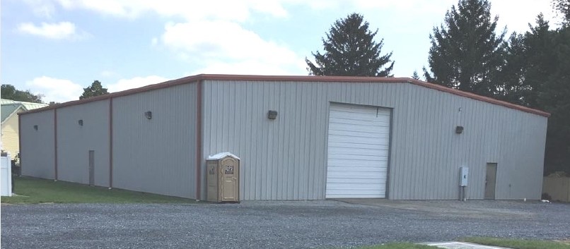
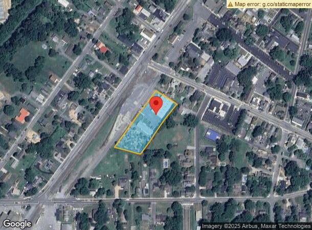
Property Record
11 N Railroad Ave, Wyoming, DE 19934
NEARBY LISTINGS FOR SALE OR LEASE
Property Detail
11 N Railroad Ave
7-20-09406-03-3100-000
SE SD E RAILROAD AVE 1.382 A 11 E RAILROAD AVENUE
Commercialnec
Kent
X
Delaware
10001C0231H
1.38 AC
2023
Kent County
2024
Philadelphia
042100
Dover, DE
9,600 SF
DEMOGRAPHICS near 11 N Railroad Ave
1 Mile
3 Mile
5 Mile
2024 Total Population
3,605
33,607
83,606
2029 Population
3,893
36,093
89,612
Pop Growth 2024-2029
+ 7.99%
+ 7.40%
+ 7.18%
Average Age
39
40
39
2024 Total Households
1,400
12,823
31,636
HH Growth 2024-2029
+ 8.07%
+ 7.63%
+ 7.46%
Median Household Inc
$65,067
$65,377
$63,838
Avg Household Size
2.60
2.60
2.50
2024 Avg HH Vehicles
2.00
2.00
2.00
Median Home Value
$269,520
$272,979
$276,976
Median Year Built
1986
1988
1989
Nearby Places
- Restaurants
- Banks
- Shops
- Fitness
- Groceries
SALE & LEASE HISTORY
LISTING DATE
SALE/LEASE

Aug 31, 2018
For Lease
Nearby Properties
Address
Land Use
TOTAL SIZE
Lot Size
Zoning
Address
Land Use
TOTAL SIZE
Lot Size
Zoning
308,750 SF
102.10 AC
R10
Address
Land Use
TOTAL SIZE
Lot Size
Zoning
494,672 SF
35.80 AC
NA
Address
Land Use
TOTAL SIZE
Lot Size
Zoning
95,706 SF
22.94 AC
R10
Address
Land Use
TOTAL SIZE
Lot Size
Zoning
135,552 SF
39.05 AC
AC
Address
Land Use
TOTAL SIZE
Lot Size
Zoning
93,186 SF
89.27 AC
IPM
Address
Land Use
TOTAL SIZE
Lot Size
Zoning
228,076 SF
15.50 AC
BG
Address
Land Use
TOTAL SIZE
Lot Size
Zoning
129,471 SF
TND
Address
Land Use
TOTAL SIZE
Lot Size
Zoning
108,450 SF
11 AC
RM
Address
Land Use
TOTAL SIZE
Lot Size
Zoning
189,000 SF
13.40 AC
RG2
Address
Land Use
TOTAL SIZE
Lot Size
Zoning
109,262 SF
15.03 AC
NA
Address
Land Use
TOTAL SIZE
Lot Size
Zoning
188,100 SF
9.70 AC
RG2
Address
Land Use
TOTAL SIZE
Lot Size
Zoning
136,440 SF
6.60 AC
RM1
Address
Land Use
TOTAL SIZE
Lot Size
Zoning
52,250 SF
8.50 AC
RG2
Address
Land Use
TOTAL SIZE
Lot Size
Zoning
5,529 SF
83.30 AC
NA
Address
Land Use
TOTAL SIZE
Lot Size
Zoning
190,988 SF
19.90 AC
NA
Address
Land Use
TOTAL SIZE
Lot Size
Zoning
82,457 SF
12.40 AC
SC2
Address
Land Use
TOTAL SIZE
Lot Size
Zoning
68,076 SF
2.63 AC
TND
Address
Land Use
TOTAL SIZE
Lot Size
Zoning
37,779 SF
5.90 AC
RM1
Address
Land Use
TOTAL SIZE
Lot Size
Zoning
62,572 SF
53 AC
RS1
Address
Land Use
TOTAL SIZE
Lot Size
Zoning
Address
Land Use
TOTAL SIZE
Lot Size
Zoning
91,738 SF
22.17 AC
R1
Address
Land Use
TOTAL SIZE
Lot Size
Zoning
125,394 SF
19.10 AC
RS1
Address
Land Use
TOTAL SIZE
Lot Size
Zoning
65,264 SF
13.58 AC
IO
Address
Land Use
TOTAL SIZE
Lot Size
Zoning
70,500 SF
7 AC
RM2
Address
Land Use
TOTAL SIZE
Lot Size
Zoning
93,452 SF
5 AC
IPM
Address
Land Use
TOTAL SIZE
Lot Size
Zoning
34,020 SF
20.46 AC
BN
Address
Land Use
TOTAL SIZE
Lot Size
Zoning
111,121 SF
8.40 AC
IPM
Address
Land Use
TOTAL SIZE
Lot Size
Zoning
94,050 SF
5.60 AC
RG2
Address
Land Use
TOTAL SIZE
Lot Size
Zoning
58,026 SF
17 AC
NA
Address
Land Use
TOTAL SIZE
Lot Size
Zoning
41,588 SF
19.64 AC
AP/10
The World's #1 Commercial Real Estate Marketplace
Connect with us
© 2025 CoStar Group
The information above has been obtained from sources believed reliable. While we do not doubt its accuracy we have not verified it and make no guarantee, warranty or representation about it. It is your responsibility to independently confirm its accuracy and completeness. Any projections, opinions, assumptions, or estimates used are for example only and do not represent the current or future performance of the property. The value of this transaction to you depends on tax and other factors which should be evaluated by your tax, financial, and legal advisors. You and your advisors should conduct a careful, independent investigation of the property to determine to your satisfaction the suitability of the property for your needs.