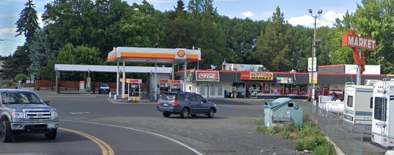
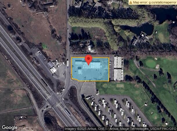
Property Record
11 Pence Rd, Yakima, WA 98908
NEARBY LISTINGS FOR SALE OR LEASE
-
-
View all Yakima listings for sale on LoopNet.com
Property Detail
11 Pence Rd
181304-33012
BEG S 0 D 30'E 36.5 FT OF NW COR SW1/4 SW1/4 TH S 0 D 30'E 214.33 FT,TH S 89 D 57'35 E 374.30 FT,TH N 0 D 02' 25 E 214.22 FT,TH N 89 D 57'35 W-- 376.32 FT TO POB EX W 30 FT CO RD REC 6/85-212744-DE FRIES-GIFFORD
Supermarket
Yakima
AE
Washington
53077C0714E
1.69 AC
2024
Outlying Yakima County
2023
Yakima
003400
Yakima, WA
9,652 SF
DEMOGRAPHICS near 11 Pence Rd
1 Mile
3 Mile
5 Mile
2024 Total Population
1,548
25,646
93,952
2029 Population
1,527
25,901
94,701
Pop Growth 2024-2029
(1.36%)
+ 0.99%
+ 0.80%
Average Age
42
42
39
2024 Total Households
560
10,312
35,462
HH Growth 2024-2029
(1.43%)
+ 1.09%
+ 0.76%
Median Household Inc
$85,849
$69,465
$63,056
Avg Household Size
2.60
2.40
2.50
2024 Avg HH Vehicles
2.00
2.00
2.00
Median Home Value
$338,636
$321,726
$282,850
Median Year Built
1981
1978
1974
Nearby Places
- Restaurants
- Banks
- Shops
- Fitness
- Groceries
PUBLIC TRANSPORTATION
AIRPORT
Yakima Air Trml/McAllister Field
DRIVE
WALK
Distance
Yakima Air Trml/McAllister Field
13 min
6.5 mi
Freight Ports
Port of Tacoma
DRIVE
WALK
Distance
Port of Tacoma
185 min
157.6 mi
Nearby Properties
Address
Land Use
TOTAL SIZE
Lot Size
Zoning
Address
Land Use
TOTAL SIZE
Lot Size
Zoning
501,270 SF
21.09 AC
M1
Address
Land Use
TOTAL SIZE
Lot Size
Zoning
235,222 SF
14.23 AC
M1
Address
Land Use
TOTAL SIZE
Lot Size
Zoning
65,606 SF
3.39 AC
R2
Address
Land Use
TOTAL SIZE
Lot Size
Zoning
69,675 SF
10.48 AC
R1
Address
Land Use
TOTAL SIZE
Lot Size
Zoning
124,505 SF
13.59 AC
R1
Address
Land Use
TOTAL SIZE
Lot Size
Zoning
98,397 SF
17.48 AC
R1
Address
Land Use
TOTAL SIZE
Lot Size
Zoning
162,933 SF
14.96 AC
SCC
Address
Land Use
TOTAL SIZE
Lot Size
Zoning
118,830 SF
5.34 AC
LCC
Address
Land Use
TOTAL SIZE
Lot Size
Zoning
196,486 SF
10.61 AC
M1
Address
Land Use
TOTAL SIZE
Lot Size
Zoning
255,977 SF
12.08 AC
M1
Address
Land Use
TOTAL SIZE
Lot Size
Zoning
29,752 SF
2.17 AC
B1
Address
Land Use
TOTAL SIZE
Lot Size
Zoning
65,968 SF
1.51 AC
R2
Address
Land Use
TOTAL SIZE
Lot Size
Zoning
116,192 SF
6.34 AC
R3
Address
Land Use
TOTAL SIZE
Lot Size
Zoning
57,223 SF
2.98 AC
B1
Address
Land Use
TOTAL SIZE
Lot Size
Zoning
43,167 SF
2.90 AC
BCOM
Address
Land Use
TOTAL SIZE
Lot Size
Zoning
30,041 SF
4.12 AC
B1
Address
Land Use
TOTAL SIZE
Lot Size
Zoning
68,852 SF
3.37 AC
R3
Address
Land Use
TOTAL SIZE
Lot Size
Zoning
80,981 SF
7 AC
LCC
Address
Land Use
TOTAL SIZE
Lot Size
Zoning
62,277 SF
2.62 AC
R3
Address
Land Use
TOTAL SIZE
Lot Size
Zoning
38,201 SF
4.54 AC
BCOM
Address
Land Use
TOTAL SIZE
Lot Size
Zoning
60,204 SF
2.49 AC
R1
Address
Land Use
TOTAL SIZE
Lot Size
Zoning
51,440 SF
1.60 AC
R3
Address
Land Use
TOTAL SIZE
Lot Size
Zoning
48,577 SF
3.76 AC
B1
Address
Land Use
TOTAL SIZE
Lot Size
Zoning
67,584 SF
5.28 AC
R3
Address
Land Use
TOTAL SIZE
Lot Size
Zoning
124,108 SF
9.65 AC
R3
Address
Land Use
TOTAL SIZE
Lot Size
Zoning
95,489 SF
4.23 AC
M1
Address
Land Use
TOTAL SIZE
Lot Size
Zoning
39,451 SF
3.56 AC
BCOM
Address
Land Use
TOTAL SIZE
Lot Size
Zoning
121,926 SF
7.28 AC
M1
Address
Land Use
TOTAL SIZE
Lot Size
Zoning
162,644 SF
10.07 AC
M1
Address
Land Use
TOTAL SIZE
Lot Size
Zoning
45,465 SF
1.50 AC
R3
The World's #1 Commercial Real Estate Marketplace
Connect with us
© 2025 CoStar Group
The information above has been obtained from sources believed reliable. While we do not doubt its accuracy we have not verified it and make no guarantee, warranty or representation about it. It is your responsibility to independently confirm its accuracy and completeness. Any projections, opinions, assumptions, or estimates used are for example only and do not represent the current or future performance of the property. The value of this transaction to you depends on tax and other factors which should be evaluated by your tax, financial, and legal advisors. You and your advisors should conduct a careful, independent investigation of the property to determine to your satisfaction the suitability of the property for your needs.