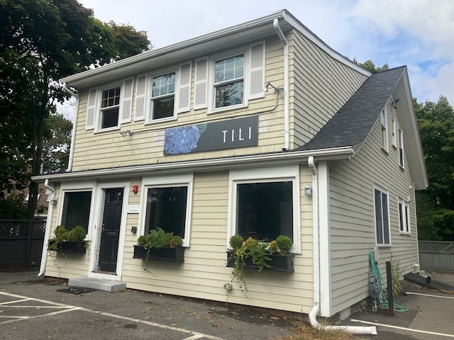
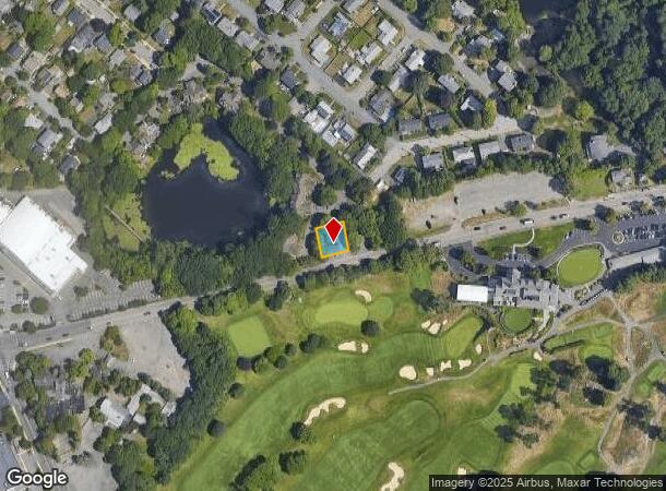
Property Record
11 Vinnin St, Salem, MA 01970

Current Lease Availabilities
NEARBY LISTINGS FOR SALE OR LEASE
-
-
-
-
-
-
-
No Photo
-
View all Salem listings for lease on LoopNet.com
Property Detail
11 Vinnin St
SALE-000030-000000-000001
Essex
Storebuilding
Massachusetts
X
1
25009C0532G
0.14 AC
2025
Peabody/Salem
2025
Boston
204200
Boston-Cambridge-Newton, MA-NH
2,028 SF
DEMOGRAPHICS near 11 Vinnin St
1 Mile
3 Mile
5 Mile
2024 Total Population
14,844
121,583
232,722
2029 Population
14,874
119,811
229,557
Pop Growth 2024-2029
+ 0.20%
(1.46%)
(1.36%)
Average Age
42
41
40
2024 Total Households
5,492
48,029
90,770
HH Growth 2024-2029
+ 0.11%
(1.60%)
(1.45%)
Median Household Inc
$116,245
$79,406
$77,171
Avg Household Size
2.40
2.40
2.50
2024 Avg HH Vehicles
2.00
2.00
2.00
Median Home Value
$651,888
$561,487
$498,243
Median Year Built
1968
1948
1949
Nearby Places
- Restaurants
- Banks
- Shops
- Fitness
- Groceries
PUBLIC TRANSPORTATION
COMMUTER RAIL
Swampscott (Newburyport/Rockport Line - Massachusetts Bay Transportation Authority Commuter Rail (Purple Line))
DRIVE
WALK
Distance
Swampscott (Newburyport/Rockport Line - Massachusetts Bay Transportation Authority Commuter Rail (Purple Line))
4 min
1.9 mi
Salem (Newburyport/Rockport Line - Massachusetts Bay Transportation Authority Commuter Rail (Purple Line))
DRIVE
WALK
Distance
Salem (Newburyport/Rockport Line - Massachusetts Bay Transportation Authority Commuter Rail (Purple Line))
6 min
3.4 mi
AIRPORT
General Edward Lawrence Logan International
DRIVE
WALK
Distance
General Edward Lawrence Logan International
22 min
12.5 mi
Freight Ports
Port of Boston
DRIVE
WALK
Distance
Port of Boston
28 min
15.2 mi
Nearby Properties
Address
Land Use
TOTAL SIZE
Lot Size
Zoning
Address
Land Use
TOTAL SIZE
Lot Size
Zoning
14.69 AC
I
Address
Land Use
TOTAL SIZE
Lot Size
Zoning
9,860 SF
17.80 AC
R1
Address
Land Use
TOTAL SIZE
Lot Size
Zoning
192,341 SF
2.10 AC
B5
Address
Land Use
TOTAL SIZE
Lot Size
Zoning
154,524 SF
11.80 AC
B3
Address
Land Use
TOTAL SIZE
Lot Size
Zoning
29.12 AC
I
Address
Land Use
TOTAL SIZE
Lot Size
Zoning
303,568 SF
1.11 AC
LI
Address
Land Use
TOTAL SIZE
Lot Size
Zoning
38,440 SF
8.95 AC
I
Address
Land Use
TOTAL SIZE
Lot Size
Zoning
123,903 SF
0.88 AC
CBD
Address
Land Use
TOTAL SIZE
Lot Size
Zoning
223,689 SF
11.60 AC
R1
Address
Land Use
TOTAL SIZE
Lot Size
Zoning
205,353 SF
18.74 AC
Address
Land Use
TOTAL SIZE
Lot Size
Zoning
190,000 SF
24.42 AC
N/A
Address
Land Use
TOTAL SIZE
Lot Size
Zoning
4.14 AC
NRCC
Address
Land Use
TOTAL SIZE
Lot Size
Zoning
68,296 SF
6.01 AC
R2
Address
Land Use
TOTAL SIZE
Lot Size
Zoning
9.58 AC
R3
Address
Land Use
TOTAL SIZE
Lot Size
Zoning
84,681 SF
3.53 AC
R5
Address
Land Use
TOTAL SIZE
Lot Size
Zoning
123,588 SF
1.50 AC
B5
Address
Land Use
TOTAL SIZE
Lot Size
Zoning
125,862 SF
5.30 AC
R1
Address
Land Use
TOTAL SIZE
Lot Size
Zoning
5 AC
B2
Address
Land Use
TOTAL SIZE
Lot Size
Zoning
77,392 SF
13.64 AC
B3
Address
Land Use
TOTAL SIZE
Lot Size
Zoning
80,069 SF
3.13 AC
A-2
Address
Land Use
TOTAL SIZE
Lot Size
Zoning
76,589 SF
4.57 AC
R4
Address
Land Use
TOTAL SIZE
Lot Size
Zoning
7.28 AC
R3
Address
Land Use
TOTAL SIZE
Lot Size
Zoning
229,416 SF
29.62 AC
N/A
Address
Land Use
TOTAL SIZE
Lot Size
Zoning
40,939 SF
12.48 AC
Address
Land Use
TOTAL SIZE
Lot Size
Zoning
19.52 AC
R3
Address
Land Use
TOTAL SIZE
Lot Size
Zoning
22.35 AC
R1
Address
Land Use
TOTAL SIZE
Lot Size
Zoning
174,401 SF
10.85 AC
HI
Address
Land Use
TOTAL SIZE
Lot Size
Zoning
13.26 AC
B2
Address
Land Use
TOTAL SIZE
Lot Size
Zoning
116,126 SF
15 AC
R1
Address
Land Use
TOTAL SIZE
Lot Size
Zoning
31.90 AC
I
The World's #1 Commercial Real Estate Marketplace
Connect with us
© 2025 CoStar Group
The information above has been obtained from sources believed reliable. While we do not doubt its accuracy we have not verified it and make no guarantee, warranty or representation about it. It is your responsibility to independently confirm its accuracy and completeness. Any projections, opinions, assumptions, or estimates used are for example only and do not represent the current or future performance of the property. The value of this transaction to you depends on tax and other factors which should be evaluated by your tax, financial, and legal advisors. You and your advisors should conduct a careful, independent investigation of the property to determine to your satisfaction the suitability of the property for your needs.