Property Record
110 Linden Ave, Red Hook, NY 12571
NEARBY LISTINGS FOR SALE OR LEASE
-
-
View all Red Hook listings for sale on LoopNet.com
Property Detail
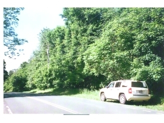
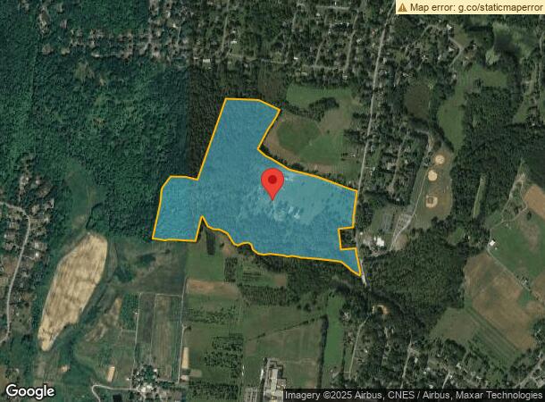
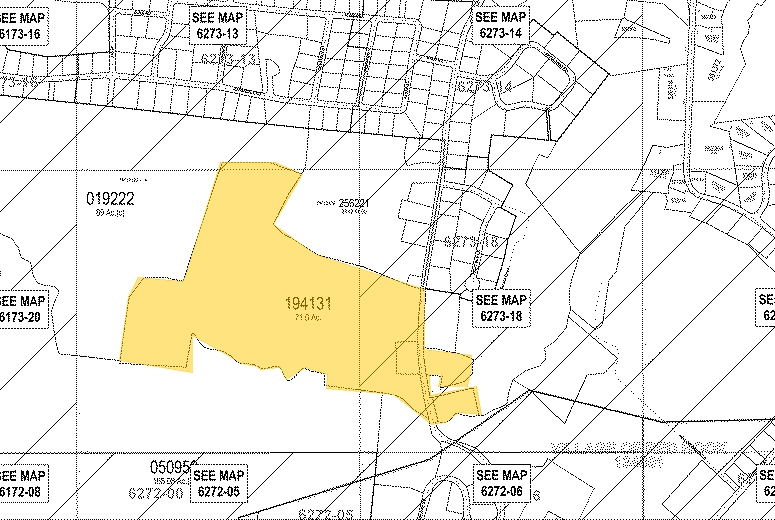
110 Linden Ave
134889-6273-00-194131-0000
71 AC. 1828 0338 1368 0441
Poultryranch
Dutchess
AE
New York
36027C0019E
194
2024
70.99 AC
2023
Fishkill
150004
Westchester/So Connecticut
1,560 SF
Dutchess County-Putnam County, NY
DEMOGRAPHICS near 110 Linden Ave
1 Mile
3 Mile
5 Mile
2024 Total Population
2,528
7,882
18,033
2029 Population
2,524
7,929
18,004
Pop Growth 2024-2029
(0.16%)
+ 0.60%
(0.16%)
Average Age
44
44
44
2024 Total Households
1,039
3,078
7,282
HH Growth 2024-2029
(0.19%)
+ 0.58%
(0.22%)
Median Household Inc
$106,405
$101,130
$93,712
Avg Household Size
2.40
2.40
2.40
2024 Avg HH Vehicles
2.00
2.00
2.00
Median Home Value
$404,276
$385,656
$379,622
Median Year Built
1968
1969
1973
Nearby Places
- Restaurants
- Banks
- Shops
- Fitness
- Groceries
PUBLIC TRANSPORTATION
COMMUTER RAIL
Rhinecliff Amtrak Station (Adirondack - Amtrak, Empire Service - Amtrak, Ethan Allen Express - Amtrak, Lake Shore Limited - Amtrak, Maple Leaf - Amtrak)
DRIVE
WALK
Distance
Rhinecliff Amtrak Station (Adirondack - Amtrak, Empire Service - Amtrak, Ethan Allen Express - Amtrak, Lake Shore Limited - Amtrak, Maple Leaf - Amtrak)
18 min
9.4 mi
Rhinecliff (Toronto - New York - VIA Rail)
DRIVE
WALK
Distance
Rhinecliff (Toronto - New York - VIA Rail)
18 min
9.5 mi
Freight Ports
Albany, NY Port
DRIVE
WALK
Distance
Albany, NY Port
71 min
49.0 mi
Nearby Properties
Address
Land Use
TOTAL SIZE
Lot Size
Zoning
Address
Land Use
TOTAL SIZE
Lot Size
Zoning
2,688 SF
301.70 AC
I
Address
Land Use
TOTAL SIZE
Lot Size
Zoning
108,250 SF
16.40 AC
I
Address
Land Use
TOTAL SIZE
Lot Size
Zoning
71,940 SF
91.70 AC
I
Address
Land Use
TOTAL SIZE
Lot Size
Zoning
52,880 SF
260.28 AC
I
Address
Land Use
TOTAL SIZE
Lot Size
Zoning
10 AC
R-20
Address
Land Use
TOTAL SIZE
Lot Size
Zoning
81,289 SF
115.30 AC
I
Address
Land Use
TOTAL SIZE
Lot Size
Zoning
78.11 AC
WC
Address
Land Use
TOTAL SIZE
Lot Size
Zoning
50,180 SF
14.18 AC
TND-CC
Address
Land Use
TOTAL SIZE
Lot Size
Zoning
108,009 SF
54.40 AC
I
Address
Land Use
TOTAL SIZE
Lot Size
Zoning
1,875 SF
5.73 AC
R1.5
Address
Land Use
TOTAL SIZE
Lot Size
Zoning
27,360 SF
2.42 AC
NMU
Address
Land Use
TOTAL SIZE
Lot Size
Zoning
2.55 AC
NMU
Address
Land Use
TOTAL SIZE
Lot Size
Zoning
4,788 SF
1.62 AC
R1.5
Address
Land Use
TOTAL SIZE
Lot Size
Zoning
12,074 SF
45.41 AC
HP20
Address
Land Use
TOTAL SIZE
Lot Size
Zoning
16.58 AC
R-20
Address
Land Use
TOTAL SIZE
Lot Size
Zoning
4,999 SF
228.26 AC
ABD
Address
Land Use
TOTAL SIZE
Lot Size
Zoning
5,225 SF
432.29 AC
RD5
Address
Land Use
TOTAL SIZE
Lot Size
Zoning
11,580 SF
4.09 AC
M
Address
Land Use
TOTAL SIZE
Lot Size
Zoning
3,200 SF
142.47 AC
ABD
Address
Land Use
TOTAL SIZE
Lot Size
Zoning
5,377 SF
11.48 AC
R-10
Address
Land Use
TOTAL SIZE
Lot Size
Zoning
14,549 SF
1.10 AC
GB
Address
Land Use
TOTAL SIZE
Lot Size
Zoning
36,941 SF
13.29 AC
TND-CC
Address
Land Use
TOTAL SIZE
Lot Size
Zoning
4,896 SF
77.81 AC
RD3
Address
Land Use
TOTAL SIZE
Lot Size
Zoning
5,588 SF
60.07 AC
A3A
Address
Land Use
TOTAL SIZE
Lot Size
Zoning
138.65 AC
HP20
Address
Land Use
TOTAL SIZE
Lot Size
Zoning
8,404 SF
161.07 AC
ABD
Address
Land Use
TOTAL SIZE
Lot Size
Zoning
27,830 SF
1.33 AC
LIB
Address
Land Use
TOTAL SIZE
Lot Size
Zoning
30,180 SF
6.41 AC
TND-CC
Address
Land Use
TOTAL SIZE
Lot Size
Zoning
9,108 SF
47.15 AC
ABD
Address
Land Use
TOTAL SIZE
Lot Size
Zoning
31,180 SF
131.78 AC
ORP
The World's #1 Commercial Real Estate Marketplace
Connect with us
© 2025 CoStar Group
The information above has been obtained from sources believed reliable. While we do not doubt its accuracy we have not verified it and make no guarantee, warranty or representation about it. It is your responsibility to independently confirm its accuracy and completeness. Any projections, opinions, assumptions, or estimates used are for example only and do not represent the current or future performance of the property. The value of this transaction to you depends on tax and other factors which should be evaluated by your tax, financial, and legal advisors. You and your advisors should conduct a careful, independent investigation of the property to determine to your satisfaction the suitability of the property for your needs.