Property Record
110 Nw Singh Ln, Cary, NC 27513


NEARBY LISTINGS FOR SALE OR LEASE
-
-
View all Cary listings for sale on LoopNet.com
Property Detail
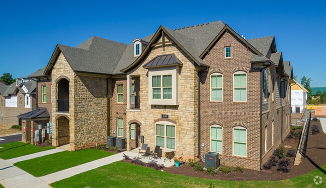
110 Nw Singh Ln
Raleigh, NC
Exempt Sub
0755.04-81-2769-000
EXEMPT SUB EASEMENT & RIGHT OF WAY DEDIC
Apartment
Wake
2025
North Carolina
2025
21.74 AC
053522
Outlying North Cary/Morrisville
312,475 SF
Raleigh/Durham
DEMOGRAPHICS near 110 Nw Singh Ln
1 Mile
3 Mile
5 Mile
2024 Total Population
11,339
71,529
176,623
2029 Population
12,362
77,682
192,112
Pop Growth 2024-2029
+ 9.02%
+ 8.60%
+ 8.77%
Average Age
37
38
38
2024 Total Households
4,609
29,329
69,498
HH Growth 2024-2029
+ 8.98%
+ 8.54%
+ 8.78%
Median Household Inc
$112,711
$104,840
$106,406
Avg Household Size
2.40
2.40
2.50
2024 Avg HH Vehicles
2.00
2.00
2.00
Median Home Value
$447,906
$421,280
$423,325
Median Year Built
1999
1996
1997
Nearby Places
Map Layers
Map Styles
 Street
 Aerial
- Restaurants
- Banks
- Shops
- Fitness
- Groceries
PUBLIC TRANSPORTATION
COMMUTER RAIL
Cary Station (Piedmont - North Carolina by Train (NC Train))
DRIVE
WALK
Distance
Cary Station (Piedmont - North Carolina by Train (NC Train))
6 min
3.3 mi
AIRPORT
Raleigh-Durham International
DRIVE
WALK
Distance
Raleigh-Durham International
12 min
5.7 mi
Freight Ports
Port of Wilmington
DRIVE
WALK
Distance
Port of Wilmington
167 min
144.0 mi
Nearby Properties
Address
Land Use
TOTAL SIZE
Lot Size
Zoning
Address
Land Use
TOTAL SIZE
Lot Size
Zoning
517,812 SF
18.51 AC
RMFP
Address
Land Use
TOTAL SIZE
Lot Size
Zoning
439,439 SF
30.59 AC
OICU
Address
Land Use
TOTAL SIZE
Lot Size
Zoning
949,404 SF
26.71 AC
OIP
Address
Land Use
TOTAL SIZE
Lot Size
Zoning
534,604 SF
16.38 AC
RMFM
Address
Land Use
TOTAL SIZE
Lot Size
Zoning
429,107 SF
13.67 AC
RMFP
Address
Land Use
TOTAL SIZE
Lot Size
Zoning
375,689 SF
32.73 AC
HDR
Address
Land Use
TOTAL SIZE
Lot Size
Zoning
312,088 SF
12.53 AC
BAC-G
Address
Land Use
TOTAL SIZE
Lot Size
Zoning
453,970 SF
41.48 AC
RMF-C
Address
Land Use
TOTAL SIZE
Lot Size
Zoning
554,316 SF
42.79 AC
ORD
Address
Land Use
TOTAL SIZE
Lot Size
Zoning
358,137 SF
22.39 AC
RMFP
Address
Land Use
TOTAL SIZE
Lot Size
Zoning
300,662 SF
12.68 AC
BAC-G
Address
Land Use
TOTAL SIZE
Lot Size
Zoning
414,214 SF
11.23 AC
OIP
Address
Land Use
TOTAL SIZE
Lot Size
Zoning
444,236 SF
8.51 AC
ORDP
Address
Land Use
TOTAL SIZE
Lot Size
Zoning
269,702 SF
14.66 AC
GCM
Address
Land Use
TOTAL SIZE
Lot Size
Zoning
368,195 SF
32.11 AC
HDR
Address
Land Use
TOTAL SIZE
Lot Size
Zoning
408,968 SF
32.58 AC
HDR
Address
Land Use
TOTAL SIZE
Lot Size
Zoning
394,181 SF
28.62 AC
HDR
Address
Land Use
TOTAL SIZE
Lot Size
Zoning
266,419 SF
77.78 AC
RA
Address
Land Use
TOTAL SIZE
Lot Size
Zoning
263,094 SF
36.79 AC
ORD
Address
Land Use
TOTAL SIZE
Lot Size
Zoning
513,738 SF
35.66 AC
OIP
Address
Land Use
TOTAL SIZE
Lot Size
Zoning
261,061 SF
18.75 AC
HDR
Address
Land Use
TOTAL SIZE
Lot Size
Zoning
579,364 SF
32.23 AC
IM
Address
Land Use
TOTAL SIZE
Lot Size
Zoning
272,508 SF
15.49 AC
NAC
Address
Land Use
TOTAL SIZE
Lot Size
Zoning
364,972 SF
35.18 AC
RMF-C
Address
Land Use
TOTAL SIZE
Lot Size
Zoning
242,305 SF
48.57 AC
R40
Address
Land Use
TOTAL SIZE
Lot Size
Zoning
282,961 SF
5.59 AC
GCP
Address
Land Use
TOTAL SIZE
Lot Size
Zoning
226,107 SF
18.72 AC
RMFP
Address
Land Use
TOTAL SIZE
Lot Size
Zoning
330,232 SF
18.45 AC
OIP
Address
Land Use
TOTAL SIZE
Lot Size
Zoning
273,637 SF
19.57 AC
C-NAC
The World's #1 Commercial Real Estate Marketplace
Connect with us
© 2026 CoStar Group
The information above has been obtained from sources believed reliable. While we do not doubt its accuracy we have not verified it and make no guarantee, warranty or representation about it. It is your responsibility to independently confirm its accuracy and completeness. Any projections, opinions, assumptions, or estimates used are for example only and do not represent the current or future performance of the property. The value of this transaction to you depends on tax and other factors which should be evaluated by your tax, financial, and legal advisors. You and your advisors should conduct a careful, independent investigation of the property to determine to your satisfaction the suitability of the property for your needs.