Property Record
1100 7 Mile Rd Nw, Comstock Park, MI 49321
NEARBY LISTINGS FOR SALE OR LEASE
Property Detail
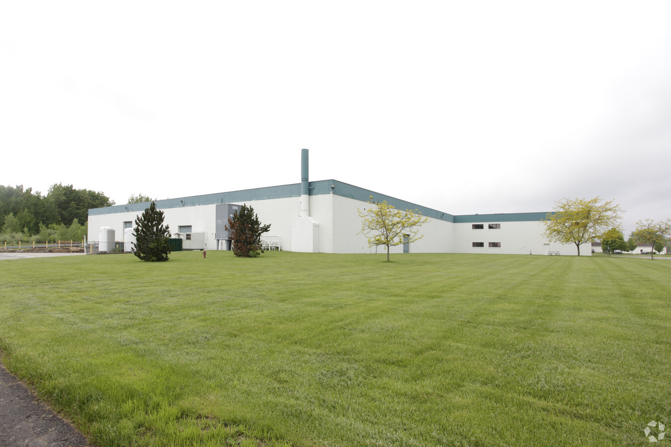
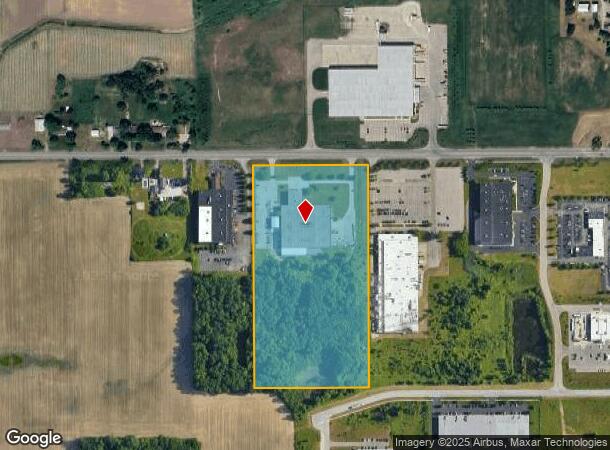
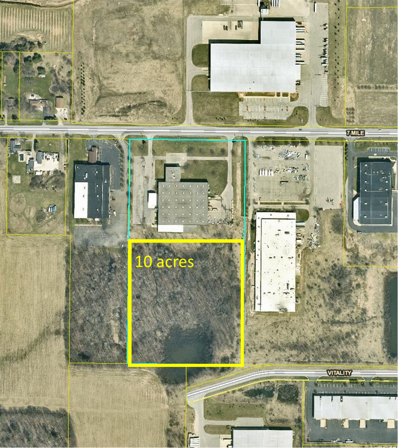
1100 7 Mile Rd Nw
Grand Rapids-Wyoming, MI
E 657.7 FT OF W 986.61 FT OF NW 1/4 NE 1/4 * SEC 23 T8N R12W 20.00 A.
41-09-23-201-002
Kent
Manufacturinglight
Michigan
2023
20 AC
2024
Comstock/Alpine
011401
West Michigan
95,524 SF
DEMOGRAPHICS near 1100 7 Mile Rd Nw
1 Mile
3 Mile
5 Mile
2024 Total Population
541
16,115
49,833
2029 Population
544
16,184
50,037
Pop Growth 2024-2029
+ 0.55%
+ 0.43%
+ 0.41%
Average Age
41
38
40
2024 Total Households
202
6,768
20,231
HH Growth 2024-2029
+ 0.99%
+ 0.49%
+ 0.43%
Median Household Inc
$64,285
$59,323
$68,930
Avg Household Size
2.50
2.30
2.40
2024 Avg HH Vehicles
2.00
2.00
2.00
Median Home Value
$246,774
$238,582
$237,912
Median Year Built
1974
1983
1978
Nearby Places
- Restaurants
- Banks
- Shops
- Fitness
- Groceries
PUBLIC TRANSPORTATION
COMMUTER RAIL
Grand Rapids Vernon J. Ehlers Station (Pere Marquette - Amtrak)
DRIVE
WALK
Distance
Grand Rapids Vernon J. Ehlers Station (Pere Marquette - Amtrak)
14 min
9.6 mi
AIRPORT
Gerald R Ford International
DRIVE
WALK
Distance
Gerald R Ford International
32 min
22.1 mi
Freight Ports
Port Milwaukee
DRIVE
WALK
Distance
Port Milwaukee
317 min
270.7 mi
SALE & LEASE HISTORY
LISTING DATE
SALE/LEASE

Sep 24, 2020
For Sale
Nearby Properties
Address
Land Use
TOTAL SIZE
Lot Size
Zoning
Address
Land Use
TOTAL SIZE
Lot Size
Zoning
169,898 SF
Address
Land Use
TOTAL SIZE
Lot Size
Zoning
33.06 AC
R-3
Address
Land Use
TOTAL SIZE
Lot Size
Zoning
Address
Land Use
TOTAL SIZE
Lot Size
Zoning
32.63 AC
R-3
Address
Land Use
TOTAL SIZE
Lot Size
Zoning
239,172 SF
25.79 AC
C-2
Address
Land Use
TOTAL SIZE
Lot Size
Zoning
Address
Land Use
TOTAL SIZE
Lot Size
Zoning
Address
Land Use
TOTAL SIZE
Lot Size
Zoning
9.11 AC
R-3
Address
Land Use
TOTAL SIZE
Lot Size
Zoning
8.77 AC
R-3
Address
Land Use
TOTAL SIZE
Lot Size
Zoning
169,926 SF
8.52 AC
C-2
Address
Land Use
TOTAL SIZE
Lot Size
Zoning
11.86 AC
R-3
Address
Land Use
TOTAL SIZE
Lot Size
Zoning
221,081 SF
22.91 AC
C-2
Address
Land Use
TOTAL SIZE
Lot Size
Zoning
10.48 AC
R-3
Address
Land Use
TOTAL SIZE
Lot Size
Zoning
Address
Land Use
TOTAL SIZE
Lot Size
Zoning
13.22 AC
R-3
Address
Land Use
TOTAL SIZE
Lot Size
Zoning
Address
Land Use
TOTAL SIZE
Lot Size
Zoning
100,800 SF
I-1
Address
Land Use
TOTAL SIZE
Lot Size
Zoning
2,676 SF
12.32 AC
R-3
Address
Land Use
TOTAL SIZE
Lot Size
Zoning
11.39 AC
R-3
Address
Land Use
TOTAL SIZE
Lot Size
Zoning
10.85 AC
R-3
Address
Land Use
TOTAL SIZE
Lot Size
Zoning
138,105 SF
18.27 AC
C-2
Address
Land Use
TOTAL SIZE
Lot Size
Zoning
117,225 SF
22.01 AC
I-1
Address
Land Use
TOTAL SIZE
Lot Size
Zoning
39,760 SF
Address
Land Use
TOTAL SIZE
Lot Size
Zoning
97,078 SF
10.67 AC
C-PUD
Address
Land Use
TOTAL SIZE
Lot Size
Zoning
171,155 SF
14.47 AC
I-2
Address
Land Use
TOTAL SIZE
Lot Size
Zoning
9.71 AC
R-3
Address
Land Use
TOTAL SIZE
Lot Size
Zoning
44,455 SF
6.77 AC
I-1
Address
Land Use
TOTAL SIZE
Lot Size
Zoning
Address
Land Use
TOTAL SIZE
Lot Size
Zoning
21,000 SF
2.78 AC
C-PUD
Address
Land Use
TOTAL SIZE
Lot Size
Zoning
6.56 AC
The World's #1 Commercial Real Estate Marketplace
Connect with us
© 2025 CoStar Group
The information above has been obtained from sources believed reliable. While we do not doubt its accuracy we have not verified it and make no guarantee, warranty or representation about it. It is your responsibility to independently confirm its accuracy and completeness. Any projections, opinions, assumptions, or estimates used are for example only and do not represent the current or future performance of the property. The value of this transaction to you depends on tax and other factors which should be evaluated by your tax, financial, and legal advisors. You and your advisors should conduct a careful, independent investigation of the property to determine to your satisfaction the suitability of the property for your needs.