Property Record
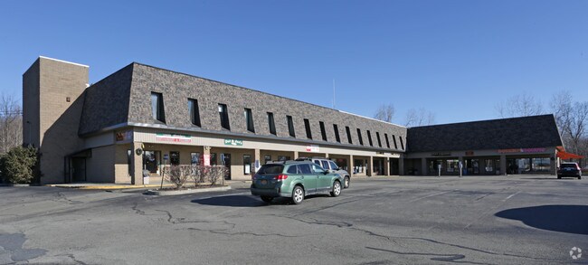
1100 Route 52, Carmel, NY 10512


NEARBY LISTINGS FOR SALE OR LEASE
-
-
View all Carmel listings for sale on LoopNet.com
Property Detail
1100 Route 52
372200-012-000-0001-055-000-0000
Putnam
Regionalshoppingcenterormallwithanchorstore
New York
X
55.00
36079C0131E
3.06 AC
2023
Carmel
2024
Westchester/So Connecticut
010500
Dutchess County-Putnam County, NY
34,496 SF
DEMOGRAPHICS near 1100 Route 52
1 Mile
3 Mile
5 Mile
2024 Total Population
718
10,939
26,959
2029 Population
720
10,987
27,060
Pop Growth 2024-2029
+ 0.28%
+ 0.44%
+ 0.37%
Average Age
43
43
43
2024 Total Households
259
4,033
10,032
HH Growth 2024-2029
+ 0.39%
+ 0.40%
+ 0.37%
Median Household Inc
$119,951
$107,516
$107,512
Avg Household Size
2.70
2.70
2.60
2024 Avg HH Vehicles
2.00
2.00
2.00
Median Home Value
$343,055
$341,769
$367,131
Median Year Built
1970
1963
1971
Nearby Places
Map Layers
Map Styles
 Street
 Aerial
- Restaurants
- Banks
- Shops
- Fitness
- Groceries
PUBLIC TRANSPORTATION
COMMUTER RAIL
Patterson Station (Harlem Line - Metro-North Commuter Railroad Company (Metro-North))
DRIVE
WALK
Distance
Patterson Station (Harlem Line - Metro-North Commuter Railroad Company (Metro-North))
14 min
7.6 mi
Southeast Station (Harlem Line - Metro-North Commuter Railroad Company (Metro-North))
DRIVE
WALK
Distance
Southeast Station (Harlem Line - Metro-North Commuter Railroad Company (Metro-North))
17 min
8.1 mi
AIRPORT
New York Stewart International
DRIVE
WALK
Distance
New York Stewart International
40 min
28.4 mi
Westchester County
DRIVE
WALK
Distance
Westchester County
45 min
34.7 mi
Freight Ports
Port of New Haven
DRIVE
WALK
Distance
Port of New Haven
79 min
54.3 mi
SALE & LEASE HISTORY
LISTING DATE
SALE/LEASE

Sep 25, 2016
For Lease
Oct 20, 2021
For Sale
May 09, 2022
For Sale
Mar 31, 2017
For Lease
Nearby Properties
Address
Land Use
TOTAL SIZE
Lot Size
Zoning
Address
Land Use
TOTAL SIZE
Lot Size
Zoning
36,877 SF
65.72 AC
R10
Address
Land Use
TOTAL SIZE
Lot Size
Zoning
101,756 SF
25.78 AC
R40
Address
Land Use
TOTAL SIZE
Lot Size
Zoning
40,613 SF
49.91 AC
I
Address
Land Use
TOTAL SIZE
Lot Size
Zoning
72,040 SF
9.87 AC
I
Address
Land Use
TOTAL SIZE
Lot Size
Zoning
33,627 SF
57.08 AC
R80
Address
Land Use
TOTAL SIZE
Lot Size
Zoning
581.90 AC
R4
Address
Land Use
TOTAL SIZE
Lot Size
Zoning
18,286 SF
152.66 AC
R4
Address
Land Use
TOTAL SIZE
Lot Size
Zoning
2,727 SF
1.37 AC
IOC
Address
Land Use
TOTAL SIZE
Lot Size
Zoning
3,360 SF
4.89 AC
IOC
Address
Land Use
TOTAL SIZE
Lot Size
Zoning
22.03 AC
IOC
Address
Land Use
TOTAL SIZE
Lot Size
Zoning
149.68 AC
C1
Address
Land Use
TOTAL SIZE
Lot Size
Zoning
21,160 SF
3.54 AC
R40
Address
Land Use
TOTAL SIZE
Lot Size
Zoning
11.20 AC
R3
Address
Land Use
TOTAL SIZE
Lot Size
Zoning
21,620 SF
88.76 AC
R80
Address
Land Use
TOTAL SIZE
Lot Size
Zoning
60,828 SF
6.95 AC
R80
Address
Land Use
TOTAL SIZE
Lot Size
Zoning
616 SF
63.50 AC
R10
Address
Land Use
TOTAL SIZE
Lot Size
Zoning
19,495 SF
11.88 AC
IOC
Address
Land Use
TOTAL SIZE
Lot Size
Zoning
0.23 AC
R4
Address
Land Use
TOTAL SIZE
Lot Size
Zoning
129.60 AC
R3
Address
Land Use
TOTAL SIZE
Lot Size
Zoning
210.40 AC
R40
Address
Land Use
TOTAL SIZE
Lot Size
Zoning
25,395 SF
3 AC
I
Address
Land Use
TOTAL SIZE
Lot Size
Zoning
15,573 SF
6.24 AC
I
Address
Land Use
TOTAL SIZE
Lot Size
Zoning
20,000 SF
4.92 AC
I
Address
Land Use
TOTAL SIZE
Lot Size
Zoning
18,332 SF
3.30 AC
IOC
Address
Land Use
TOTAL SIZE
Lot Size
Zoning
7,542 SF
270 AC
R40
Address
Land Use
TOTAL SIZE
Lot Size
Zoning
170.78 AC
R80
Address
Land Use
TOTAL SIZE
Lot Size
Zoning
3,768 SF
714.60 AC
R80
Address
Land Use
TOTAL SIZE
Lot Size
Zoning
11,738 SF
62.46 AC
R80
Address
Land Use
TOTAL SIZE
Lot Size
Zoning
19,200 SF
2.18 AC
I
The World's #1 Commercial Real Estate Marketplace
Connect with us
© 2026 CoStar Group
The information above has been obtained from sources believed reliable. While we do not doubt its accuracy we have not verified it and make no guarantee, warranty or representation about it. It is your responsibility to independently confirm its accuracy and completeness. Any projections, opinions, assumptions, or estimates used are for example only and do not represent the current or future performance of the property. The value of this transaction to you depends on tax and other factors which should be evaluated by your tax, financial, and legal advisors. You and your advisors should conduct a careful, independent investigation of the property to determine to your satisfaction the suitability of the property for your needs.