Property Record
1107 W Citizens Pkwy, North Port, FL 34288
NEARBY LISTINGS FOR SALE OR LEASE
-
-
-
S Toledo Blade & Price Lane Junction
North Port, FL 34288
Rent Upon Request
28.97 - 31.97 AC Lot
Land
-
-
-
-
-
View all North Port listings for sale on LoopNet.com
Property Detail
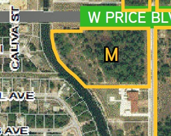
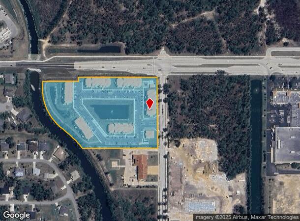
1107 W Citizens Pkwy
North Port-Sarasota-Bradenton, FL
Maxfield Office Park Phase 2
0984-02-0100
LOT 1, LESS R/W FOR PRICE BLVD AS DESC IN ORI 2008038421, MAXFIELD OFFICE PARK, PHASE 2, CONTAINING 8.4 C-AC M/L
Multifamilydwelling
Sarasota
AE
Florida
12115C0383F
1
2023
8.44 AC
2024
Sarasota Outlying
002742
Tampa/St Petersburg
136,260 SF
DEMOGRAPHICS near 1107 W Citizens Pkwy
1 Mile
3 Mile
5 Mile
2024 Total Population
4,522
40,450
74,357
2029 Population
5,198
46,527
86,099
Pop Growth 2024-2029
+ 14.95%
+ 15.02%
+ 15.79%
Average Age
41
42
44
2024 Total Households
1,648
15,042
29,184
HH Growth 2024-2029
+ 14.81%
+ 14.98%
+ 15.92%
Median Household Inc
$94,196
$76,978
$68,526
Avg Household Size
2.70
2.60
2.50
2024 Avg HH Vehicles
2.00
2.00
2.00
Median Home Value
$243,278
$254,498
$245,803
Median Year Built
2004
2004
2002
Nearby Places
- Restaurants
- Banks
- Shops
- Fitness
- Groceries
PUBLIC TRANSPORTATION
AIRPORT
Punta Gorda
DRIVE
WALK
Distance
Punta Gorda
28 min
21.0 mi
Freight Ports
Port Manatee
DRIVE
WALK
Distance
Port Manatee
70 min
57.9 mi
SALE & LEASE HISTORY
LISTING DATE
SALE/LEASE

Apr 05, 2017
For Sale
Nearby Properties
Address
Land Use
TOTAL SIZE
Lot Size
Zoning
Address
Land Use
TOTAL SIZE
Lot Size
Zoning
316,994 SF
40.88 AC
V
Address
Land Use
TOTAL SIZE
Lot Size
Zoning
287,899 SF
26.96 AC
AC4
Address
Land Use
TOTAL SIZE
Lot Size
Zoning
262,144 SF
18.13 AC
AC5
Address
Land Use
TOTAL SIZE
Lot Size
Zoning
218,356 SF
17.14 AC
AC2
Address
Land Use
TOTAL SIZE
Lot Size
Zoning
285,000 SF
148.79 AC
PCDN
Address
Land Use
TOTAL SIZE
Lot Size
Zoning
146,932 SF
39.48 AC
AC2
Address
Land Use
TOTAL SIZE
Lot Size
Zoning
145,713 SF
30.50 AC
GU
Address
Land Use
TOTAL SIZE
Lot Size
Zoning
54,876 SF
23.57 AC
AC4
Address
Land Use
TOTAL SIZE
Lot Size
Zoning
233,560 SF
46.42 AC
AC5
Address
Land Use
TOTAL SIZE
Lot Size
Zoning
94,423 SF
12.87 AC
V
Address
Land Use
TOTAL SIZE
Lot Size
Zoning
72,301 SF
11.72 AC
AC5
Address
Land Use
TOTAL SIZE
Lot Size
Zoning
114,985 SF
29.77 AC
GU
Address
Land Use
TOTAL SIZE
Lot Size
Zoning
88,808 SF
27.42 AC
GU
Address
Land Use
TOTAL SIZE
Lot Size
Zoning
52,706 SF
4.81 AC
V
Address
Land Use
TOTAL SIZE
Lot Size
Zoning
52,925 SF
7.49 AC
V
Address
Land Use
TOTAL SIZE
Lot Size
Zoning
65,103 SF
10.16 AC
AC2
Address
Land Use
TOTAL SIZE
Lot Size
Zoning
96,325 SF
5.73 AC
AC4
Address
Land Use
TOTAL SIZE
Lot Size
Zoning
54,710 SF
8.48 AC
AC4
Address
Land Use
TOTAL SIZE
Lot Size
Zoning
36,000 SF
2.87 AC
AC4
Address
Land Use
TOTAL SIZE
Lot Size
Zoning
43,387 SF
5.09 AC
AC2
Address
Land Use
TOTAL SIZE
Lot Size
Zoning
40,789 SF
20.91 AC
AC4
Address
Land Use
TOTAL SIZE
Lot Size
Zoning
92,904 SF
7.98 AC
AC4
Address
Land Use
TOTAL SIZE
Lot Size
Zoning
19,816 SF
2.70 AC
AC2
Address
Land Use
TOTAL SIZE
Lot Size
Zoning
35,600 SF
13.19 AC
AC4
Address
Land Use
TOTAL SIZE
Lot Size
Zoning
29.90 AC
AC4
Address
Land Use
TOTAL SIZE
Lot Size
Zoning
5,399 SF
2.10 AC
AC5
Address
Land Use
TOTAL SIZE
Lot Size
Zoning
10,000 SF
51.86 AC
AC5
Address
Land Use
TOTAL SIZE
Lot Size
Zoning
6,570 SF
2.17 AC
AC2
Address
Land Use
TOTAL SIZE
Lot Size
Zoning
30,000 SF
5.66 AC
AC4
The World's #1 Commercial Real Estate Marketplace
Connect with us
© 2025 CoStar Group
The information above has been obtained from sources believed reliable. While we do not doubt its accuracy we have not verified it and make no guarantee, warranty or representation about it. It is your responsibility to independently confirm its accuracy and completeness. Any projections, opinions, assumptions, or estimates used are for example only and do not represent the current or future performance of the property. The value of this transaction to you depends on tax and other factors which should be evaluated by your tax, financial, and legal advisors. You and your advisors should conduct a careful, independent investigation of the property to determine to your satisfaction the suitability of the property for your needs.