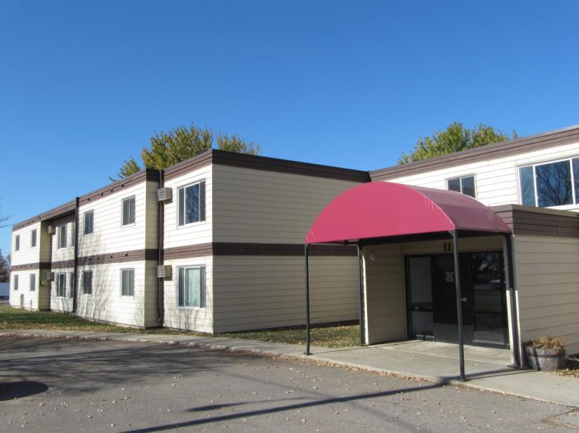
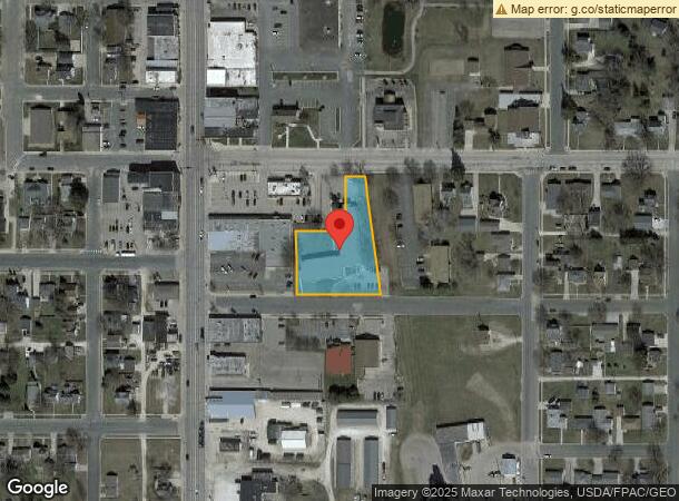
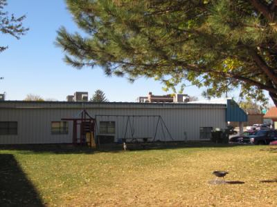
Property Record
111 2Nd St Se, Stewartville, MN 55976
NEARBY LISTINGS FOR SALE OR LEASE
-
-
View all Stewartville listings for sale on LoopNet.com
Property Detail
111 2Nd St Se
Rochester, MN
City Lands 105-14-34
54.34.42.030667
SECT-34 TWP-105 RANGE-014 CITY LANDS 105-14-34 TH PT SEC 34 DES AS FOLLOWS BEG AT SECOR LOT 6 BLK 2 THIRD SOUTH ADD TH SLY PA
Apartment
Olmsted
X
Minnesota
27045C0025E
6
2023
0.94 AC
2023
Rochester
0021002011
Other Market Areas
864 SF
DEMOGRAPHICS near 111 2Nd St Se
1 Mile
3 Mile
5 Mile
2024 Total Population
5,001
7,093
7,792
2029 Population
5,074
7,222
7,904
Pop Growth 2024-2029
+ 1.46%
+ 1.82%
+ 1.44%
Average Age
39
38
38
2024 Total Households
1,959
2,723
2,989
HH Growth 2024-2029
+ 1.33%
+ 1.73%
+ 1.34%
Median Household Inc
$81,601
$84,593
$85,632
Avg Household Size
2.50
2.60
2.60
2024 Avg HH Vehicles
2.00
2.00
2.00
Median Home Value
$266,694
$264,224
$271,183
Median Year Built
1977
1985
1985
Nearby Places
- Restaurants
- Banks
- Shops
- Fitness
- Groceries
PUBLIC TRANSPORTATION
AIRPORT
Rochester International
DRIVE
WALK
Distance
Rochester International
9 min
5.5 mi
Freight Ports
Port Milwaukee
DRIVE
WALK
Distance
Port Milwaukee
306 min
279.3 mi
Nearby Properties
Address
Land Use
TOTAL SIZE
Lot Size
Zoning
Address
Land Use
TOTAL SIZE
Lot Size
Zoning
968 SF
52.22 AC
Address
Land Use
TOTAL SIZE
Lot Size
Zoning
600 SF
18.52 AC
Address
Land Use
TOTAL SIZE
Lot Size
Zoning
58,144 SF
2.97 AC
Address
Land Use
TOTAL SIZE
Lot Size
Zoning
117,752 SF
19.92 AC
Address
Land Use
TOTAL SIZE
Lot Size
Zoning
12,032 SF
6.03 AC
Address
Land Use
TOTAL SIZE
Lot Size
Zoning
60,228 SF
7.51 AC
Address
Land Use
TOTAL SIZE
Lot Size
Zoning
Address
Land Use
TOTAL SIZE
Lot Size
Zoning
33.82 AC
Address
Land Use
TOTAL SIZE
Lot Size
Zoning
65,924 SF
15.14 AC
Address
Land Use
TOTAL SIZE
Lot Size
Zoning
49,931 SF
1.42 AC
Address
Land Use
TOTAL SIZE
Lot Size
Zoning
7,422 SF
13.57 AC
Address
Land Use
TOTAL SIZE
Lot Size
Zoning
35,011 SF
8.88 AC
Address
Land Use
TOTAL SIZE
Lot Size
Zoning
13.02 AC
Address
Land Use
TOTAL SIZE
Lot Size
Zoning
46,900 SF
3.14 AC
Address
Land Use
TOTAL SIZE
Lot Size
Zoning
29,609 SF
0.40 AC
Address
Land Use
TOTAL SIZE
Lot Size
Zoning
15,468 SF
2.34 AC
Address
Land Use
TOTAL SIZE
Lot Size
Zoning
231,582 SF
3.49 AC
Address
Land Use
TOTAL SIZE
Lot Size
Zoning
57,304 SF
8.43 AC
Address
Land Use
TOTAL SIZE
Lot Size
Zoning
21,600 SF
4.92 AC
Address
Land Use
TOTAL SIZE
Lot Size
Zoning
24,988 SF
4.80 AC
Address
Land Use
TOTAL SIZE
Lot Size
Zoning
28,659 SF
1.47 AC
Address
Land Use
TOTAL SIZE
Lot Size
Zoning
22,324 SF
3.22 AC
Address
Land Use
TOTAL SIZE
Lot Size
Zoning
30,786 SF
3.89 AC
Address
Land Use
TOTAL SIZE
Lot Size
Zoning
2,349 SF
14.10 AC
Address
Land Use
TOTAL SIZE
Lot Size
Zoning
14,168 SF
11.86 AC
Address
Land Use
TOTAL SIZE
Lot Size
Zoning
14,246 SF
2.21 AC
Address
Land Use
TOTAL SIZE
Lot Size
Zoning
1,614 SF
160 AC
Address
Land Use
TOTAL SIZE
Lot Size
Zoning
28,756 SF
1.34 AC
Address
Land Use
TOTAL SIZE
Lot Size
Zoning
13,336 SF
3.03 AC
The World's #1 Commercial Real Estate Marketplace
Connect with us
© 2025 CoStar Group
The information above has been obtained from sources believed reliable. While we do not doubt its accuracy we have not verified it and make no guarantee, warranty or representation about it. It is your responsibility to independently confirm its accuracy and completeness. Any projections, opinions, assumptions, or estimates used are for example only and do not represent the current or future performance of the property. The value of this transaction to you depends on tax and other factors which should be evaluated by your tax, financial, and legal advisors. You and your advisors should conduct a careful, independent investigation of the property to determine to your satisfaction the suitability of the property for your needs.