Property Record
1110 Hendersonville Hwy, Pisgah Forest, NC 28768
NEARBY LISTINGS FOR SALE OR LEASE
-
-
View all Pisgah Forest listings for sale on LoopNet.com
Property Detail
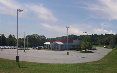
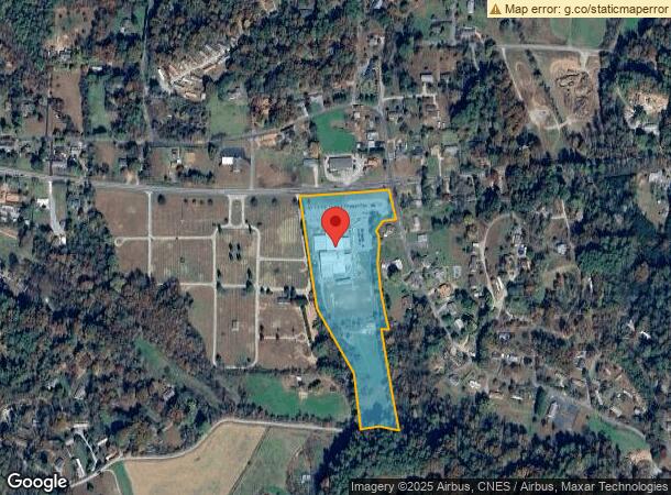
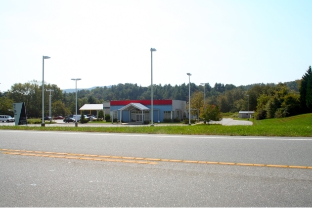
1110 Hendersonville Hwy
9507-02-3957-000
Recombination Plat For Challenge Foundat
Publicschool
US HWY 64
X
Transylvania
3700950700J
North Carolina
0
10.98 AC
2024
Other Market Areas
960100
Brevard, NC
39,812 SF
DEMOGRAPHICS near 1110 Hendersonville Hwy
1 Mile
3 Mile
5 Mile
2024 Total Population
1,450
6,496
17,943
2029 Population
1,471
6,608
18,241
Pop Growth 2024-2029
+ 1.45%
+ 1.72%
+ 1.66%
Average Age
43
45
45
2024 Total Households
594
2,781
7,643
HH Growth 2024-2029
+ 1.35%
+ 1.65%
+ 1.57%
Median Household Inc
$54,698
$59,227
$56,565
Avg Household Size
2.40
2.20
2.20
2024 Avg HH Vehicles
2.00
2.00
2.00
Median Home Value
$215,508
$255,087
$283,497
Median Year Built
1978
1979
1979
Nearby Places
- Restaurants
- Banks
- Shops
- Fitness
- Groceries
PUBLIC TRANSPORTATION
AIRPORT
Asheville Regional
DRIVE
WALK
Distance
Asheville Regional
25 min
16.5 mi
Freight Ports
North Charleston Terminal
DRIVE
WALK
Distance
North Charleston Terminal
292 min
253.0 mi
Nearby Properties
Address
Land Use
TOTAL SIZE
Lot Size
Zoning
Address
Land Use
TOTAL SIZE
Lot Size
Zoning
25.70 AC
OI
Address
Land Use
TOTAL SIZE
Lot Size
Zoning
62,646 SF
10.02 AC
R1
Address
Land Use
TOTAL SIZE
Lot Size
Zoning
80,469 SF
14.60 AC
R2
Address
Land Use
TOTAL SIZE
Lot Size
Zoning
61,155 SF
11.06 AC
R1
Address
Land Use
TOTAL SIZE
Lot Size
Zoning
37,298 SF
6.22 AC
C4
Address
Land Use
TOTAL SIZE
Lot Size
Zoning
82,770 SF
8.74 AC
C4
Address
Land Use
TOTAL SIZE
Lot Size
Zoning
51,024 SF
1.33 AC
C2
Address
Land Use
TOTAL SIZE
Lot Size
Zoning
14,036 SF
6.88 AC
C4
Address
Land Use
TOTAL SIZE
Lot Size
Zoning
34,574 SF
7.46 AC
OI
Address
Land Use
TOTAL SIZE
Lot Size
Zoning
11,000 SF
6.10 AC
C4
Address
Land Use
TOTAL SIZE
Lot Size
Zoning
1,760 SF
26.38 AC
OI
Address
Land Use
TOTAL SIZE
Lot Size
Zoning
60,750 SF
6.94 AC
Address
Land Use
TOTAL SIZE
Lot Size
Zoning
38,686 SF
4.16 AC
Address
Land Use
TOTAL SIZE
Lot Size
Zoning
49,569 SF
6.22 AC
Address
Land Use
TOTAL SIZE
Lot Size
Zoning
8,850 SF
218.53 AC
Address
Land Use
TOTAL SIZE
Lot Size
Zoning
37,579 SF
1.97 AC
Address
Land Use
TOTAL SIZE
Lot Size
Zoning
7,976 SF
3.45 AC
Address
Land Use
TOTAL SIZE
Lot Size
Zoning
20,183 SF
1.75 AC
C4
Address
Land Use
TOTAL SIZE
Lot Size
Zoning
15,743 SF
36.50 AC
R1
Address
Land Use
TOTAL SIZE
Lot Size
Zoning
55,150 SF
6.50 AC
C4
Address
Land Use
TOTAL SIZE
Lot Size
Zoning
21,395 SF
10.09 AC
Address
Land Use
TOTAL SIZE
Lot Size
Zoning
11,978 SF
1.74 AC
C4
Address
Land Use
TOTAL SIZE
Lot Size
Zoning
13,667 SF
0.01 AC
Address
Land Use
TOTAL SIZE
Lot Size
Zoning
18,442 SF
4.89 AC
R1
Address
Land Use
TOTAL SIZE
Lot Size
Zoning
4,164 SF
2 AC
C4
Address
Land Use
TOTAL SIZE
Lot Size
Zoning
14,830 SF
3.10 AC
C4
Address
Land Use
TOTAL SIZE
Lot Size
Zoning
19,256 SF
3.30 AC
C4
The World's #1 Commercial Real Estate Marketplace
Connect with us
© 2025 CoStar Group
The information above has been obtained from sources believed reliable. While we do not doubt its accuracy we have not verified it and make no guarantee, warranty or representation about it. It is your responsibility to independently confirm its accuracy and completeness. Any projections, opinions, assumptions, or estimates used are for example only and do not represent the current or future performance of the property. The value of this transaction to you depends on tax and other factors which should be evaluated by your tax, financial, and legal advisors. You and your advisors should conduct a careful, independent investigation of the property to determine to your satisfaction the suitability of the property for your needs.