Property Record
5587 Sam O Neal Rd, Baker, FL 32531
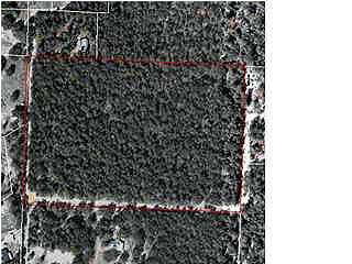

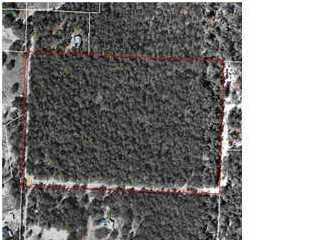
This Property Is For Sale
NEARBY LISTINGS FOR SALE OR LEASE
-
-
View all Baker listings for sale on LoopNet.com
Property Detail
5587 Sam O Neal Rd
10-3N-24-0000-0003-0020
BEG 660 FT N OF SW COR OF NW1/4 OF NW1/4 N 660 FT E 990 FT S 660 FT W 990 FT
Agriculturalland
Okaloosa
X
Florida
12091C0145J
15.27 AC
2023
Fort Walton Beach
2023
Other Market Areas
020101
Crestview-Fort Walton Beach-Destin, FL
4,334 SF
DEMOGRAPHICS near 5587 Sam O Neal Rd
1 Mile
3 Mile
5 Mile
2024 Total Population
272
6,390
23,909
2029 Population
286
6,790
25,245
Pop Growth 2024-2029
+ 5.15%
+ 6.26%
+ 5.59%
Average Age
40
38
37
2024 Total Households
101
2,323
8,586
HH Growth 2024-2029
+ 5.94%
+ 6.24%
+ 5.51%
Median Household Inc
$85,416
$72,932
$63,206
Avg Household Size
2.60
2.70
2.60
2024 Avg HH Vehicles
2.00
2.00
2.00
Median Home Value
$279,166
$267,960
$249,340
Median Year Built
2001
2002
2000
Nearby Places
- Restaurants
- Banks
- Shops
- Fitness
- Groceries
PUBLIC TRANSPORTATION
AIRPORT
Eglin AFB/Destin-Ft Walton Beach
DRIVE
WALK
Distance
Eglin AFB/Destin-Ft Walton Beach
59 min
30.5 mi
Freight Ports
Port of Panama City
DRIVE
WALK
Distance
Port of Panama City
127 min
92.8 mi
Nearby Properties
Address
Land Use
TOTAL SIZE
Lot Size
Zoning
Address
Land Use
TOTAL SIZE
Lot Size
Zoning
190,812 SF
4.14 AC
Address
Land Use
TOTAL SIZE
Lot Size
Zoning
33,162 SF
4.48 AC
Address
Land Use
TOTAL SIZE
Lot Size
Zoning
50,564 SF
9.90 AC
Address
Land Use
TOTAL SIZE
Lot Size
Zoning
36,224 SF
8.26 AC
Address
Land Use
TOTAL SIZE
Lot Size
Zoning
39,937 SF
51.25 AC
Address
Land Use
TOTAL SIZE
Lot Size
Zoning
48,957 SF
20.60 AC
Address
Land Use
TOTAL SIZE
Lot Size
Zoning
18,355 SF
9.25 AC
Address
Land Use
TOTAL SIZE
Lot Size
Zoning
7,950 SF
12.31 AC
Address
Land Use
TOTAL SIZE
Lot Size
Zoning
25,318 SF
0.80 AC
Address
Land Use
TOTAL SIZE
Lot Size
Zoning
13,398 SF
108.17 AC
Address
Land Use
TOTAL SIZE
Lot Size
Zoning
11,204 SF
1.20 AC
Address
Land Use
TOTAL SIZE
Lot Size
Zoning
13,936 SF
2.28 AC
Address
Land Use
TOTAL SIZE
Lot Size
Zoning
12,935 SF
769.86 AC
Address
Land Use
TOTAL SIZE
Lot Size
Zoning
7,804 SF
10.63 AC
Address
Land Use
TOTAL SIZE
Lot Size
Zoning
9,230 SF
2 AC
Address
Land Use
TOTAL SIZE
Lot Size
Zoning
5,889 SF
28.54 AC
Address
Land Use
TOTAL SIZE
Lot Size
Zoning
26,909 SF
0.93 AC
Address
Land Use
TOTAL SIZE
Lot Size
Zoning
6,285 SF
19.81 AC
Address
Land Use
TOTAL SIZE
Lot Size
Zoning
7,022 SF
40.50 AC
Address
Land Use
TOTAL SIZE
Lot Size
Zoning
41,300 SF
0.97 AC
Address
Land Use
TOTAL SIZE
Lot Size
Zoning
16,252 SF
3.72 AC
Address
Land Use
TOTAL SIZE
Lot Size
Zoning
5,808 SF
39.16 AC
Address
Land Use
TOTAL SIZE
Lot Size
Zoning
8,010 SF
110 AC
Address
Land Use
TOTAL SIZE
Lot Size
Zoning
11,320 SF
1.78 AC
Address
Land Use
TOTAL SIZE
Lot Size
Zoning
3,649 SF
1.49 AC
Address
Land Use
TOTAL SIZE
Lot Size
Zoning
3,506 SF
2.84 AC
Address
Land Use
TOTAL SIZE
Lot Size
Zoning
14,943 SF
4.61 AC
Address
Land Use
TOTAL SIZE
Lot Size
Zoning
7,631 SF
1.78 AC
Address
Land Use
TOTAL SIZE
Lot Size
Zoning
3,556 SF
10 AC
Address
Land Use
TOTAL SIZE
Lot Size
Zoning
7,342 SF
143 AC
The World's #1 Commercial Real Estate Marketplace
Connect with us
© 2025 CoStar Group
The information above has been obtained from sources believed reliable. While we do not doubt its accuracy we have not verified it and make no guarantee, warranty or representation about it. It is your responsibility to independently confirm its accuracy and completeness. Any projections, opinions, assumptions, or estimates used are for example only and do not represent the current or future performance of the property. The value of this transaction to you depends on tax and other factors which should be evaluated by your tax, financial, and legal advisors. You and your advisors should conduct a careful, independent investigation of the property to determine to your satisfaction the suitability of the property for your needs.