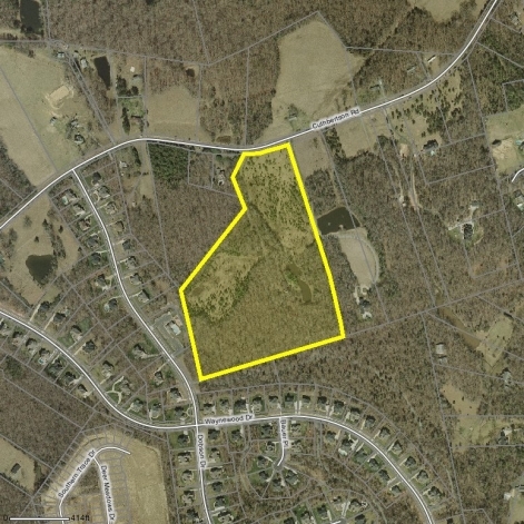
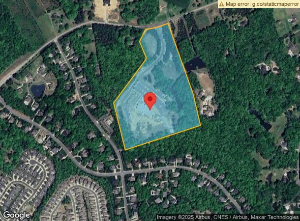
Property Record
1121 Cuthbertson Rd, Waxhaw, NC 28173
NEARBY LISTINGS FOR SALE OR LEASE
Property Detail
1121 Cuthbertson Rd
06-105-014-B
OBERMILLER 1117 CUTHB
Religious
Union
X
North Carolina
3710448500J
25.25 AC
2024
Union County
2024
Charlotte
021012
Charlotte-Concord-Gastonia, NC-SC
20,153 SF
DEMOGRAPHICS near 1121 Cuthbertson Rd
1 Mile
3 Mile
5 Mile
2024 Total Population
4,024
28,827
78,938
2029 Population
4,477
32,124
89,145
Pop Growth 2024-2029
+ 11.26%
+ 11.44%
+ 12.93%
Average Age
36
38
38
2024 Total Households
1,123
8,644
24,402
HH Growth 2024-2029
+ 11.40%
+ 11.66%
+ 13.22%
Median Household Inc
$141,513
$149,240
$141,652
Avg Household Size
3.60
3.30
3.20
2024 Avg HH Vehicles
2.00
2.00
2.00
Median Home Value
$489,034
$485,622
$480,202
Median Year Built
2010
2006
2006
Nearby Places
- Restaurants
- Banks
- Shops
- Fitness
- Groceries
PUBLIC TRANSPORTATION
AIRPORT
Charlotte/Douglas International
DRIVE
WALK
Distance
Charlotte/Douglas International
43 min
25.9 mi
Concord-Padgett Regional
DRIVE
WALK
Distance
Concord-Padgett Regional
53 min
38.4 mi
Freight Ports
North Charleston Terminal
DRIVE
WALK
Distance
North Charleston Terminal
228 min
186.4 mi
Nearby Properties
Address
Land Use
TOTAL SIZE
Lot Size
Zoning
Address
Land Use
TOTAL SIZE
Lot Size
Zoning
208,338 SF
114.77 AC
RE WEDDING
Address
Land Use
TOTAL SIZE
Lot Size
Zoning
170,725 SF
199.20 AC
R-40 UNION
Address
Land Use
TOTAL SIZE
Lot Size
Zoning
79,858 SF
28.88 AC
CU C-3 WAX
Address
Land Use
TOTAL SIZE
Lot Size
Zoning
97,083 SF
32.54 AC
R-40 WESLE
Address
Land Use
TOTAL SIZE
Lot Size
Zoning
60,741 SF
9.77 AC
B-2 WESLEY
Address
Land Use
TOTAL SIZE
Lot Size
Zoning
48,464 SF
12.45 AC
R-40 WESLE
Address
Land Use
TOTAL SIZE
Lot Size
Zoning
124,562 SF
10.68 AC
B-2 WESLEY
Address
Land Use
TOTAL SIZE
Lot Size
Zoning
58,089 SF
10.22 AC
CU C-3 WAX
Address
Land Use
TOTAL SIZE
Lot Size
Zoning
141,212 SF
14.59 AC
CU C-3 WAX
Address
Land Use
TOTAL SIZE
Lot Size
Zoning
43,706 SF
10.37 AC
CU C-3 WAX
Address
Land Use
TOTAL SIZE
Lot Size
Zoning
28.11 AC
R-6 UNION
Address
Land Use
TOTAL SIZE
Lot Size
Zoning
61.15 AC
CU R-1 WAX
Address
Land Use
TOTAL SIZE
Lot Size
Zoning
161.60 AC
CU C-3 WAX
Address
Land Use
TOTAL SIZE
Lot Size
Zoning
270.46 AC
R-40 UNION
Address
Land Use
TOTAL SIZE
Lot Size
Zoning
27,899 SF
22.06 AC
R-40 UNION
Address
Land Use
TOTAL SIZE
Lot Size
Zoning
106.50 AC
RCD WEDDIN
Address
Land Use
TOTAL SIZE
Lot Size
Zoning
32,450 SF
5.87 AC
R-40 UNION
Address
Land Use
TOTAL SIZE
Lot Size
Zoning
769.64 AC
RA-40 UNIO
Address
Land Use
TOTAL SIZE
Lot Size
Zoning
Address
Land Use
TOTAL SIZE
Lot Size
Zoning
145.32 AC
RCD WEDDIN
Address
Land Use
TOTAL SIZE
Lot Size
Zoning
27,290 SF
2.64 AC
C-3 WAXHAW
Address
Land Use
TOTAL SIZE
Lot Size
Zoning
95.91 AC
CU C-3 WAX
Address
Land Use
TOTAL SIZE
Lot Size
Zoning
23,974 SF
3.96 AC
R-40 WESLE
Address
Land Use
TOTAL SIZE
Lot Size
Zoning
25,840 SF
2.64 AC
C-3 WAXHAW
Address
Land Use
TOTAL SIZE
Lot Size
Zoning
41,356 SF
5.35 AC
CU C-3 WAX
Address
Land Use
TOTAL SIZE
Lot Size
Zoning
15.06 AC
B-2 WESLEY
Address
Land Use
TOTAL SIZE
Lot Size
Zoning
0.94 AC
RCD WEDDIN
Address
Land Use
TOTAL SIZE
Lot Size
Zoning
7,092 SF
5.95 AC
B-2 WESLEY
Address
Land Use
TOTAL SIZE
Lot Size
Zoning
6,186 SF
6.31 AC
OI WESLEY
The World's #1 Commercial Real Estate Marketplace
Connect with us
© 2025 CoStar Group
The information above has been obtained from sources believed reliable. While we do not doubt its accuracy we have not verified it and make no guarantee, warranty or representation about it. It is your responsibility to independently confirm its accuracy and completeness. Any projections, opinions, assumptions, or estimates used are for example only and do not represent the current or future performance of the property. The value of this transaction to you depends on tax and other factors which should be evaluated by your tax, financial, and legal advisors. You and your advisors should conduct a careful, independent investigation of the property to determine to your satisfaction the suitability of the property for your needs.