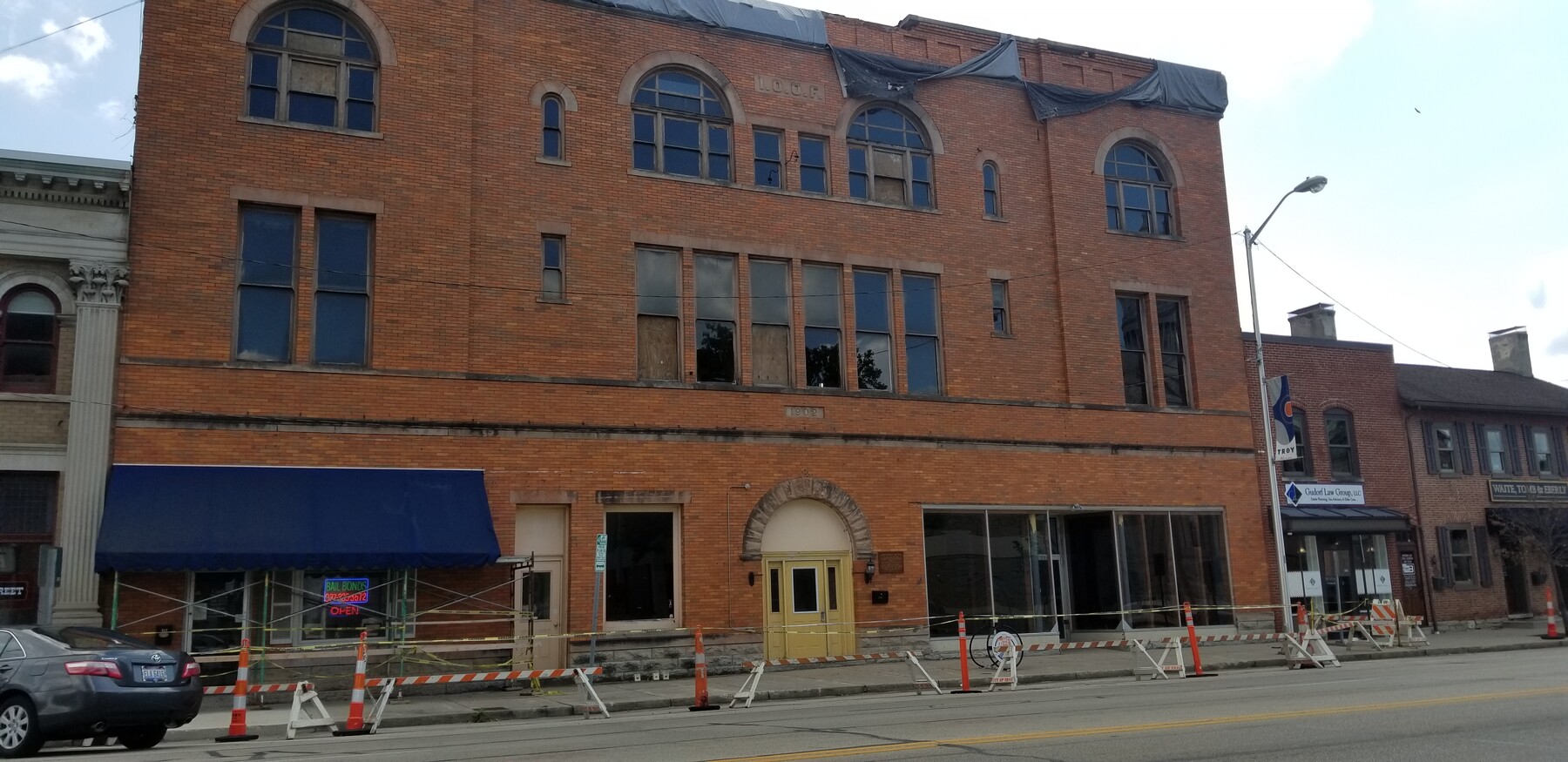
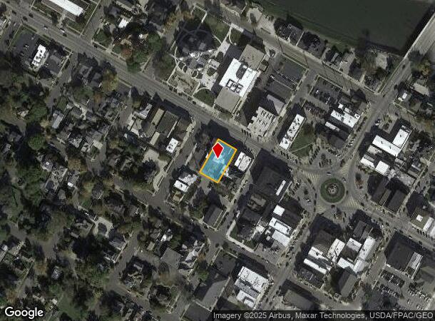
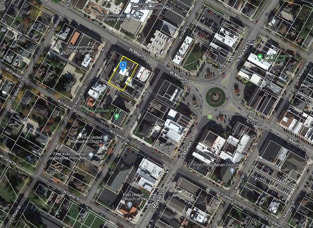
Property Record
112 W Main St, Troy, OH 45373
NEARBY LISTINGS FOR SALE OR LEASE
Property Detail
112 W Main St
Dayton, OH
Troy
D08001270
IN LOT 42 64.5 E SIDE & IN LOT 289 18.66 W SIDE
Commercialnec
Miami
X
Ohio
39109C0162F
42
2024
0.30 AC
2023
North Dayton
365301
Cincinnati/Dayton
14,736 SF
DEMOGRAPHICS near 112 W Main St
1 Mile
3 Mile
5 Mile
2024 Total Population
10,217
31,497
41,250
2029 Population
10,614
32,769
42,881
Pop Growth 2024-2029
+ 3.89%
+ 4.04%
+ 3.95%
Average Age
39
41
41
2024 Total Households
4,349
13,157
16,962
HH Growth 2024-2029
+ 3.93%
+ 4.01%
+ 3.94%
Median Household Inc
$56,251
$68,637
$71,086
Avg Household Size
2.20
2.30
2.40
2024 Avg HH Vehicles
2.00
2.00
2.00
Median Home Value
$146,493
$196,670
$212,109
Median Year Built
1949
1973
1975
Nearby Places
- Restaurants
- Banks
- Shops
- Fitness
- Groceries
PUBLIC TRANSPORTATION
AIRPORT
James M Cox Dayton International
DRIVE
WALK
Distance
James M Cox Dayton International
23 min
14.4 mi
Freight Ports
Port of Toledo
DRIVE
WALK
Distance
Port of Toledo
155 min
132.8 mi
SALE & LEASE HISTORY
LISTING DATE
SALE/LEASE

Aug 06, 2020
For Sale
Nearby Properties
Address
Land Use
TOTAL SIZE
Lot Size
Zoning
Address
Land Use
TOTAL SIZE
Lot Size
Zoning
11.71 AC
Address
Land Use
TOTAL SIZE
Lot Size
Zoning
536,448 SF
66.57 AC
Address
Land Use
TOTAL SIZE
Lot Size
Zoning
8.18 AC
Address
Land Use
TOTAL SIZE
Lot Size
Zoning
548,745 SF
56.35 AC
Address
Land Use
TOTAL SIZE
Lot Size
Zoning
48,363 SF
14.35 AC
Address
Land Use
TOTAL SIZE
Lot Size
Zoning
Address
Land Use
TOTAL SIZE
Lot Size
Zoning
8.43 AC
Address
Land Use
TOTAL SIZE
Lot Size
Zoning
1,310 SF
12.31 AC
Address
Land Use
TOTAL SIZE
Lot Size
Zoning
Address
Land Use
TOTAL SIZE
Lot Size
Zoning
7,200 SF
26.04 AC
Address
Land Use
TOTAL SIZE
Lot Size
Zoning
75,861 SF
8 AC
Address
Land Use
TOTAL SIZE
Lot Size
Zoning
132,772 SF
15.34 AC
Address
Land Use
TOTAL SIZE
Lot Size
Zoning
50,400 SF
54.09 AC
Address
Land Use
TOTAL SIZE
Lot Size
Zoning
8.94 AC
Address
Land Use
TOTAL SIZE
Lot Size
Zoning
160,000 SF
11.37 AC
Address
Land Use
TOTAL SIZE
Lot Size
Zoning
85.35 AC
Address
Land Use
TOTAL SIZE
Lot Size
Zoning
Address
Land Use
TOTAL SIZE
Lot Size
Zoning
3,944 SF
12.18 AC
Address
Land Use
TOTAL SIZE
Lot Size
Zoning
148,400 SF
37.74 AC
Address
Land Use
TOTAL SIZE
Lot Size
Zoning
32,633 SF
12.05 AC
Address
Land Use
TOTAL SIZE
Lot Size
Zoning
16.03 AC
Address
Land Use
TOTAL SIZE
Lot Size
Zoning
191,424 SF
26.97 AC
Address
Land Use
TOTAL SIZE
Lot Size
Zoning
68,679 SF
1.72 AC
Address
Land Use
TOTAL SIZE
Lot Size
Zoning
201,788 SF
10.11 AC
Address
Land Use
TOTAL SIZE
Lot Size
Zoning
54,671 SF
15.56 AC
Address
Land Use
TOTAL SIZE
Lot Size
Zoning
94,555 SF
13.32 AC
Address
Land Use
TOTAL SIZE
Lot Size
Zoning
4,700 SF
28.05 AC
Address
Land Use
TOTAL SIZE
Lot Size
Zoning
31,682 SF
2.40 AC
Address
Land Use
TOTAL SIZE
Lot Size
Zoning
211,925 SF
13 AC
Address
Land Use
TOTAL SIZE
Lot Size
Zoning
114,017 SF
6.53 AC
The World's #1 Commercial Real Estate Marketplace
Connect with us
© 2025 CoStar Group
The information above has been obtained from sources believed reliable. While we do not doubt its accuracy we have not verified it and make no guarantee, warranty or representation about it. It is your responsibility to independently confirm its accuracy and completeness. Any projections, opinions, assumptions, or estimates used are for example only and do not represent the current or future performance of the property. The value of this transaction to you depends on tax and other factors which should be evaluated by your tax, financial, and legal advisors. You and your advisors should conduct a careful, independent investigation of the property to determine to your satisfaction the suitability of the property for your needs.